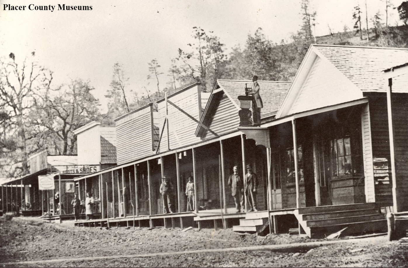
This is a fabulous photo from the Placer County Museums showing a portion of the business district of Colfax taken in the 1870s, during the town's heyday.
Sierra Nevada History
Slippery Ford to Strawberry on the Lincoln Highway, part 5
We have explored the Slippery Ford area on our eastward journey on the Lincoln Highway from Stateline to Placerville in part 4 of our El Dorado County Lincoln Highway adventure here. The Slippery Ford area is rich in history, and if you like hiking, it’s a great trip from Lover’s Leap campground to the Slippery Ford parking lot. If you are going to walk in both directions, we recommend starting at Lovers Leap campground and heading uphill first, then returning with the downhill, making it a bit easier to finish. The other option would be two cars with one parked at your destination. The walk is medium difficulty, though in the summer it can become scorching. The gravel roadbed has eroded in some areas making it difficult to walk over the small loose gravel.
Swan-Henry Toll Road and Lincoln Highway looking east.
The photo above shows a boulder that has fallen into the roadbed. We are a few hundred yards from the Slippery Ford Trail parking lot at Twin Bridges. This part of the old roadbed is easy to walk as it is not very steep. A forested area behind the photographer, a hundred yards or so, provides some welcome relief from the summer sun.
Pretty soon, we come to a wonderful rock which has been marked by old-time travelers. What era did they write this? We don’t know, but the Pony Express, Swan-Henry Toll Road, and the 1913 Lincoln Highway passed by this very rock. Someone wanted to record their passage through this historic route.
Register Rock on the Pony Express Trail, Swan-Henry Toll Road, and Lincoln Highway.
Heading down the old road a bit, we can see off to our right and below a rock building lacking a roof. At some point in the 1930s, the CCC (Civilian Conservation Corps) built this as a ski hut. Apparently, it was never finished or used. You can head down and check it out from the trail.
Ski Hut built by the CCC in the 1930s. Never used. We are looking north.
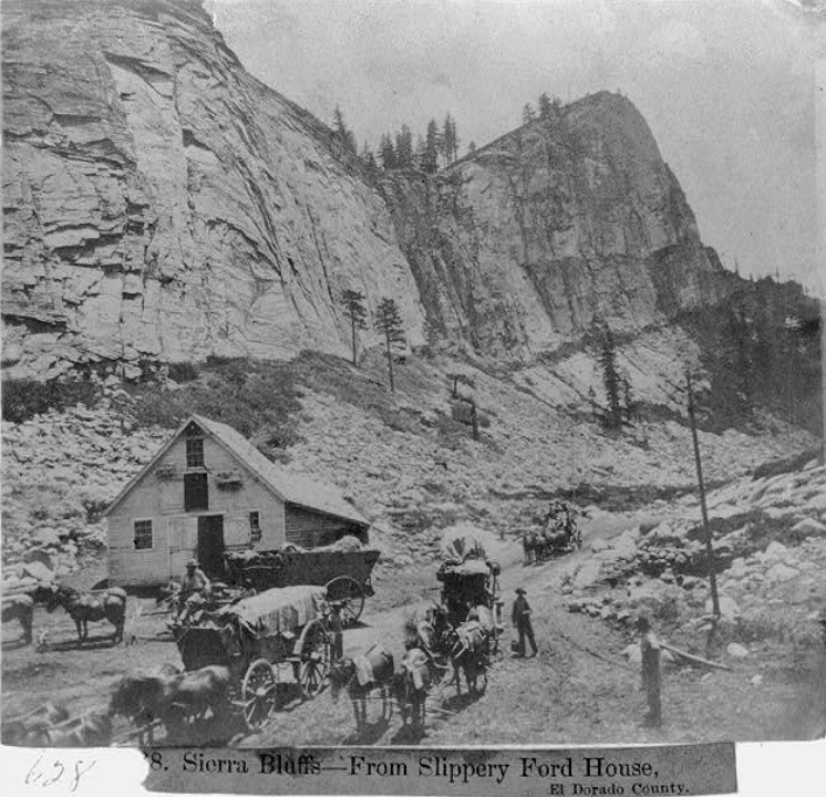
A bit further on, we come to the Slippery Ford House site, a boarding house and supply stop for travelers in the 1860’s. This spot is amazing as there is literally nothing left of this old place other than debris, which should be left in place as archeological evidence. It’s great fun to take the photo below and compare it to the site today.
1866 photo shows Slippery Ford House with teams outside. The team is headed up-hill, east, towards Slippery Ford. . Library of congress photo.
Below you will find a short video we made in 2018 at the Slippery Ford House site.
These historic photographs come to us from the Library of Congress, Lawrence & Houseworth Collection, made in 1866. Slippery Ford was famous enough they took many photographers of the area, including the Slippery Ford House. The photo below is interesting as it appears to shows the third building on site. We assumed from previous photos there were just two buildings.
From Slippery Ford House looking east on the old Swan-Henry Toll Road.
Looking at these old photos of Slippery Ford House, the first thing I notice is the roadbed's great condition. Today this road is often a jumble of rocks resembling a stream bed more than a road. This is due to erosion over the years, with water etching deeper into the ruts each year. In addition there is no road maintenance anymore, so nature is left to it’s own creation along this trail.
Monica standing in the middle of the badly eroded roadbed. You can see a old culverts sticking out of the ground. That is likely Lincoln Highway era pipe.
Monica's photo above shows how the roadbed has been eroded over the years, exposing the base, which consists of softball size and larger sized rocks. These sections of the road can be difficult to walk as every time you step the rocks move. You can see a Lincoln Highway era culvert sticking out of the ground.
Looking west towards Strawberry Valley from the Slippery Ford House, 1866. Look closely and you can see the wagons coming up the hill towards the house. Click photo for larger view. Photo from Library of Congress.
Monica and a blasted rock.
As we travel these 19th Century roads in the Sierra Nevada, we often come across these rocks with a star-shaped pattern. These rocks were just too big to move, so the road builders blasted them, making the roadbed level. Dirt would then be graded on top of the rocks to make a smooth surface for travel. That’s why many of these roads were toll roads, to pay for the ongoing maintenance.
A rock showing the star shaped pattern from blasting.
We are approaching our destination near Strawberry, and there is one more historic obejct to enjoy, Monks Rock. Hank Monk was quite famous in his day for being a devil may care stage driver, who held records for his speed of travel. It’s said that one night, when stage traffic would travel the less crowded roads, he hit his head on this rock while speeding to his destination.
Monk’ Rock, on which the famous stage drive Hank Monk hit his head while driving his stagecoach team up the Slippery Ford Trail. Photo from the Library of Congress. Click the photo for a closer version.
We have looked at Monk’s Rock trying to envision how he managed to get close enough to actually hit it. Still can’t figure it out, but it’s a great story about a big old rock, of which this area abounds.
Monks Rock.
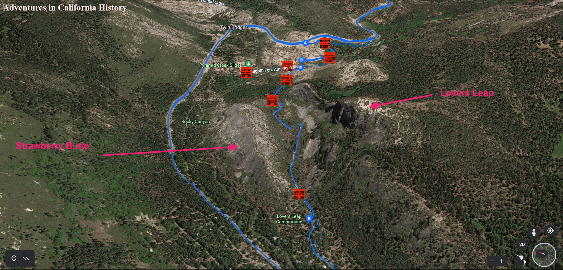
Just past Monk’s Rock, headed west towards Strawberry, the end of the hike is the Lovers Leap Campground. This campground is usually filled with rock climbers who find it thrilling to climb up the sheer side of Lovers Leap. Lover’s Leap Campground is only a short 1/4 mile from Strawberry. There is day-use parking at the campground.
Lover’s Leap Campground at Strawberry.
Now that we’re done hiking down the Slippery Ford Trail we’ll take a look around the Strawberry area in our next episode of our Lincoln Highway Adventure in El Dorado County.
The view from the Lincoln Highway/Dutch Flat Donner Lake Wagon Road.
Dog Valley to Truckee on the northern route of the Lincoln Highway, Part 4
We are now on our way up Henness Pass Road, leaving Verdi and headed towards the “First Summit.” The First Summit is where the emigrants then descended to Dog Valley to camp and feed their animals. The Lincoln Highway does not head down to the valley but follows a ridge above the valley.
Here at First Summit was Bauer’s Hotel, 1865. I couldn’t find any more information on this hotel, nor could we see any hotel's physical signs. We always find it fascinating to think there was so much traffic on this road that hotels were needed every so often. Looking at the panorama photo above, we can see the Lincoln Highway headed towards the Second Summit, a road heading down to Dog Valley, the direction the emigrants traveled, and the road to Verdi.
Dog Valley as seen from the Lincoln Highway, looking north-east.
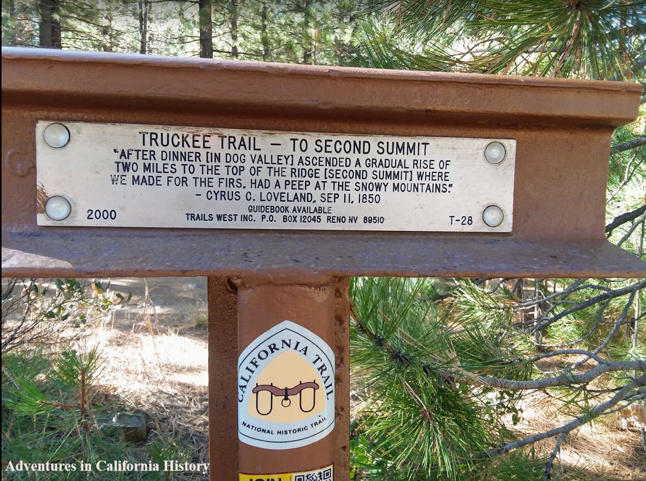
Just past the First Summit, we round a curve and the view of Dog Valley is spectacular. We intend to head down to the valley next year and check out a Trail West “T” Marker on the old trail through the valley the Emigrant Trail soon heads back up from the valley to what’s known as “Second Summit”. The Trails West “T” marker pictured below describes the scene.
The road from Verdi to Prosser Reservoir is all dirt and fairly easy to travel. The first section up from Verdi to First Summit is a beautiful example of the “washboard effect”. Once at the summit the road is easy to drive, dusty in the summer, and not recommended in the winter. In the map below we can see a portion of the Lincoln Highway headed into Stampede Reservoir, which of course was not there during the early parts of the 20th Century. We will take up that portion of the adventure on our next installment of the Lincoln Highways northern route from Verdi, NV through California.
The children of Long Valley School, Placer County, 1890
This photo from the Placer County Museums is full of personalities who once inhabited Long Valley, with a population of around 60. We see kids from the school enjoying their lunch around the school well. The teacher, looking very professorial, is enjoying a drink of that cool Long Valley water.
The fun is taking a closer look at the photo and the kids. You’ve got the older boys looking mischievous at the right while numerous younger kids look like they will burst out laughing at any moment. Be sure to check out the old-school lunch/water buckets.
One resident of Long Valley, born in 1893, was Clark Ashton Smith, writer and artist most famous for his fantasy writing along the vein of H. P. Lovecraft. You can read more about Smith here.
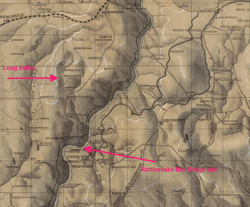
Long Valley was located on the Auburn Sacramento Road, a mile or so south of Auburn. Leaving Long Valley heading south on Rattlesnake Bar Road, you would have crossed the old Rattlesnake Bar Bridge, which we have written about before. Long Valley School still stands at the corner of Auburn Folsom Road and Rattlesnake Bar Road and is used as a community hall.
I’ve posted a map, The Georgetown Divide in 1873, and marked where the town was. To see the complete map go here.
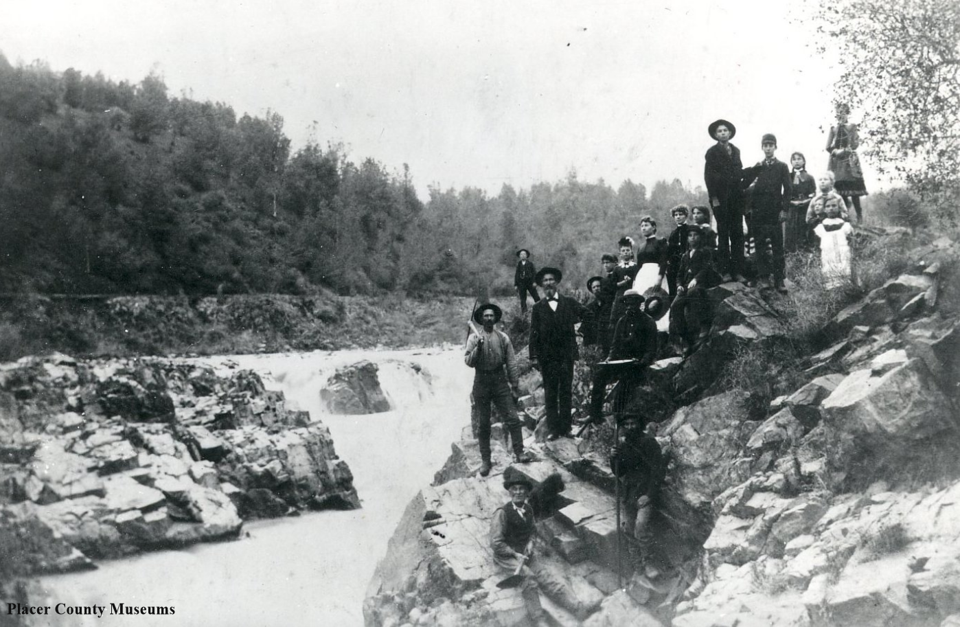
A group of people stand next to Salmon Falls.in 1887. Photo: Placer County Museums
The Falls of Salmon Falls.
There were once falls at Salmon Falls, now inundated by Folsom Reservoir. The rocks were blasted away in the 1920s, helping with logging operations, which floated timber down the river. Below is a screengrab of our 1873 map of the Georgetown Divide showing the old townsite.
Salmon Falls got its start in 1849 with miners working the creeks, including Sweetwater Creek, which the town grew up next to. Once Folsom Dam was constructed, this entire area flooded. The town’s cemetery was exhumed and the bodies re-buried at the “Re-location Cemetary” at El Dorado Hills.
In low rainfall years, the town re-emerges from its watery fate, and you can visit some of the old town sites. Here is a link to more info on this area.
1873 map showing Salmon Falls. See the entire map here.
Lincoln Highway officials checking out Dog Valley, off to the left, 1912. View is facing east. Photo from Lincoln Highway Traveler Newsletter.
Verdi to Henness Pass Road on the old Lincoln Highway northern route, part 3
Dog Valley and Henness Pass Road from Verdi to Truckee is one of the most historic in California. Besides being the Lincoln Highway's original route, this was also the Dutch Flat Donner Lake Wagon Road (DFDLWR), and before that, an emigrant trail.
The first wagon train across The Sierra was the Stevens, Townsend, Murphy party, guided by Caleb Greenwood, a trapper, in 1844. They took the only way known to them, from the area known today as Verdi. They followed the Truckee River down its narrow canyon. This was a brutal passage as the emigrants often found themselves in the water working their way upstream. It may be that they were the only wagon train to use this passage as a newer, easier route had been discovered.
Sign at the Von Schmidt Obeilisk park in Verdi, at the California border line.
That newer route was the road we are about to travel on. In 1845 Caleb Greenwood, not wishing to repeat the Truckee River route, discovered the way we are venturing on. This route avoided the waters of The Truckee and used the ridge tops and not the canyons for travel. This was the same route the Donner Party followed on their way west.
Starting in 1864, this route was also the Dutch Flat Wagon Road, which became quite busy as travelers headed west and even busier during the silver boom in Nevada with thousands traveling east. Automobiles started using this road in 1901, and in 1913 the Lincoln Highway Association chose this way for its northern route. From 1864 to 1926, this was the main route into California from points east.
Automobile traveling west on the new Truckee River Route of the second generation Lincoln Highway, soon to be Highway 40. Photo from Lincoln Highway Traveler Newsletter.
The Dog Valley route as it was called was being prepared for it’s inclusion as the new state highway when in 1926 it was decided to build the more expensive, $889,894, and difficult Truckee River route. The Dog Valley Route would have been completed for $94,000. Apparently politics played a role in the new routes construction. After 1926 all traffic was diverted down the newer Truckee River Route, Highway 40. The Dog Valley Route was abandoned and became a county road.
Trey standing by Trail West “T” marker #24. The quote by Emigrant Isaac Wistar commented that “large pines, firs and cedars abound…some of which are fully six feet through.”
As we head up Dog Valley Road, it changes to Henness Pass Road, and we spot our first Trails West “T” marker, describing the immense trees, some 6 feet wide! The emigrant trail likely followed the present-day road's general route, though likely they used the sides of the hills for passage. In the photo above the Lincoln Highway is behind the photographer by about 10 yards.
From this point up to the first summit, the road is quite rough, with the washboard effect very evident. Shake, rattle, and roll!
Echo Summit to Slippery Ford on the Lincoln Highway southern route, Part 3
Leaving Echo Summit on the old Lincoln Highway we continue our adventure west. Johnson Pass Road was the old highway, passing by the road to Echo Lake on the right. It was here that the American House roadhouse once stood during the 1800s. Later during the 1920s and 30s Echo Portals stood here. This was a resort with food and lodging as well as Echo Summits first rope tow for skiing. This resort went out of business with the arrival of the Great Depression in the early 1930s.
The early transcontinental driver making their way across the country might have used “strip maps” to guide them on their journey. In the above photo, we see one such “strip” of maps, which were originally produced by the Southern California Auto Association and is currently housed in the Library of Congress.
In the above photo, we can see the California map that was part of the “strip maps” series showing the entire country. The above map is the California section of the maps. This map showed the 1913 Lincoln Highway route heading south from Sacramento towards Stockton and the Altamont Pass. In 1928 the Carquinez Bridge near Martinez was opened, and the newer, faster route was drawing in red by someone on the above map. You still would need to take a ferry from Berkely to San Francisco.
Phillips Station, just before it burned down around in 2019.
After passing the site of Phillips Station, and old stage stop and roadhouse, we come to Sierra Springs Road off to the right. As we can see in our Lincoln Highway interactive map, that road was the Lincoln Highway! Keep your eyes open for California “C” monuments, indicating this was a state highway. We have yet to find any, so maybe you’ll be the first! Go here to find out about “C” Monuments. Let us know if you find one, or two.
Edelweiss Ski Hill along Highway 50.
Just beyond the Sierra Springs alignment, we come to Sayle’s Flat, home of Camp Sacramento. The City of Sacramento has leased this land since the 1920s for recreation. Across from Camp Sacramento once stood Edelweiss, a small ski resort that once was the home of Spyder Sabich, a world-class skier. The above photo shows the ski resort in the 1950s. Eventually, low snow years and changing habits of skiers forced the closure of this place.
Looking towards Sayles Flat from the old Edelweiss Ski Resort Hill. Camp Sacramento is just out of view at left. You can see me lower left looking at the Trails West “T” Marker.
The original 1913 alignment of the Lincoln Highway often followed the old emigrant trails in these parts. As witnessed by the Trails West Association “T” marker just downhill from the Edelweiss site, this is no exception. This is the course of Johnson’s Cut-Off trail, which guided early travelers of the 1950s and 60’s down the mountain and across the American River at a place called “Slippery Ford.” We will discuss that extraordinary place in our next blog post following the southern route (Pioneer) of the Lincoln Highway.
Greenwood School and playground, 1953. Click the photo for a larger view.
Henchey, Paul L. Greenwood School, Greenwood, El Dorado County, Calif., SV-798. UC Davis Library, Archives and Special Collections, 11 June 1953. digital.ucdavis.edu, https://digital.ucdavis.edu/collection/henchey/D-515/d3nx5j.
Greenwood, El Dorado County school and playground, 1953
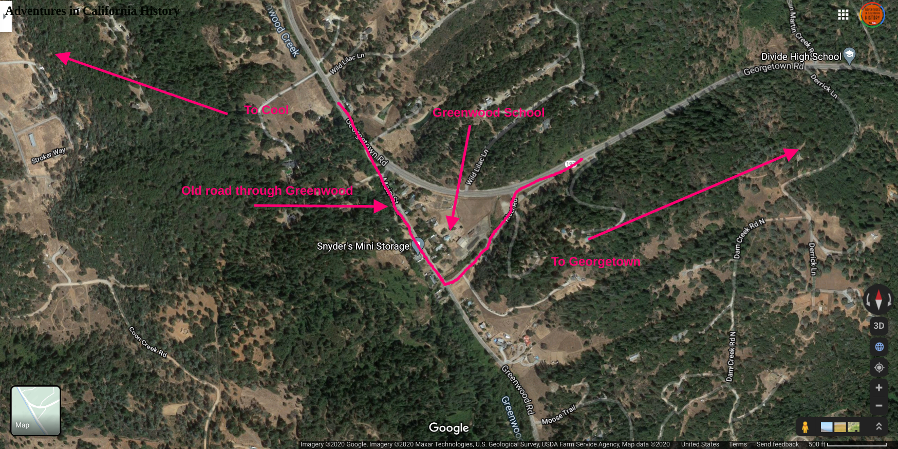
Above is a Paul L. Henchey photograph taken in June 1953 that shows the old Greenwood schoolhouse, which is still standing today. You can find the location on the map at the bottom of the post.
When you hear from the elders about how dangerous and fun old playground equipment was, this is a prime example. The merry-go-round looks to be an advanced version of other merry-grounds that did not tip. With the conventional merry-go-round, kids would propel themselves using their feet to gain speed as the contraption spun around, throwing off those who couldn’t hold on!
This merry-go-round not only spins but seems to tilt, adding to the g-forces and making it even harder to hold on. You can zoom in on the photo to get a better view.
My question for those who remember this is, how was it propelled? Does it look like there may be a handle in the center used to tilt it or propel it? Was this powered by the kid’s feet like the non-tilting versions? You can see two children playing tetherball behind the merry-go-round. A lone dog stands at the entrance.
Verdi, Nevada to the California line on the northern route of the Lincoln Highway, Part 2
In our last post about Verdi, we explored the east side of town with its dirt Lincoln Highway and old metal bridge. That post can be found here. Now let’s head back into town, following the old road as we head towards the California border.
The photo above shows Verdi and a bridge in the distance. This photo was taken by the Central Pacific Railroad around 1868, and shows a wagon heading up the road on the far right. I wonder if this bridge is the earlier version of the Crystal Peak Toll Bridge.
As we approach the town, the Lincoln Highway makes a sharp right to cross the railroad tracks. There is a Nevada Historical monument by the tracks that mentions the “Great Train Robbery” that occurred here on November 4-5, 1870, by five desperadoes. The train was the Central Pacific Overland Express. $41,600 in gold coin was taken, and after a two-state search, they were all caught, tried, and convicted. More info here.
Verdi History Center.
Sign mounted on Verdi History Center.
Once across the tracks, leave the first generation Lincoln Highway and turn left on 2nd Street, the second-generation highway. Just a couple of houses down on the left is the Verdi History Center. We have yet to come by when it’s open, but on the front of the building is a Lincoln Highway sign and a George A Wyman way-point sign.
George Wyman was a true pioneer, being the first person to cross the country on a motorized vehicle in 1903, fully ten years before the LincolnHighway. He rode and walked his motorcycle from San Francisco to New York, mostly following the railroad tracks. You can read more about this fascinating man and his epic journey here.
If you continue west on the 2nd generation Lincoln Highway, and just before the bridge, pull off and into Crystal Peak Park. There we can see the famous last crossing of the Truckee River. Above, we can see the Trails West “T” marker describing this place. There were 26th previous times that the emigrants would have to get wet crossing the river. It was quite tiring, and to reach the last crossing was something to get excited about.
We love these quiet places that, at one time, witnessed humanity on the move. Looking at the actual crossing below, we can well imagine the wagons, oxen, and people heading into the river from this side and exiting on the other.
The famous 27th emigrant crossing at the Truckee River, Verdi,Nevada, looking west.
Leaving the park, we head back towards Verdi on the 2nd generation Lincoln until we reach the first generation road and turn left onto Bridge Street. In a bit, we reach the site of the Crystal Peak bridge built-in 1928. Before this bridge, this was known as “O’Neil’s crossing.”
You can read the plaque at the bridge in the photo on at right. Click for a larger view.
Crystal Peak Bridge crossing the Truckee River.
Crystal Peak cemetery, Verdi, Nevada.
Crossing the bridge, we head past the Crystal Peak Cemetery seen above. This area was a town by the name of Crystal Peak, and here are buried some of the former residents of that long-gone place. Now we are off into California, where we stop at the Von Schmidt obelisk.
Von Schmidt Obelisk, Verdi, Nevada.
This place is fantastic! The obelisk in the protective cage was one of four monuments set in place between 1872-73 to determine the state boundary line. There are descriptive signs in this small park that will explain the importance of this spot. One such plaque is shown below.
Descriptive plaque at the Von Schmidt obelisk park.
We have come to the end of today’s adventure. Monica and I are standing in Nevada, with the road still to be driven behind us. As the sign mentions, this part of the road will become quite rough and should only be traversed during the dry season. After this spot, we will climb up Henness Pass Road towards Dog Valley, the very same valley the Donner Party camped, and countless other emigrants.
The Lincoln Highway really is your road to adventure!
Monica and I at the border between California and Nevada on the old Lincoln Highway.
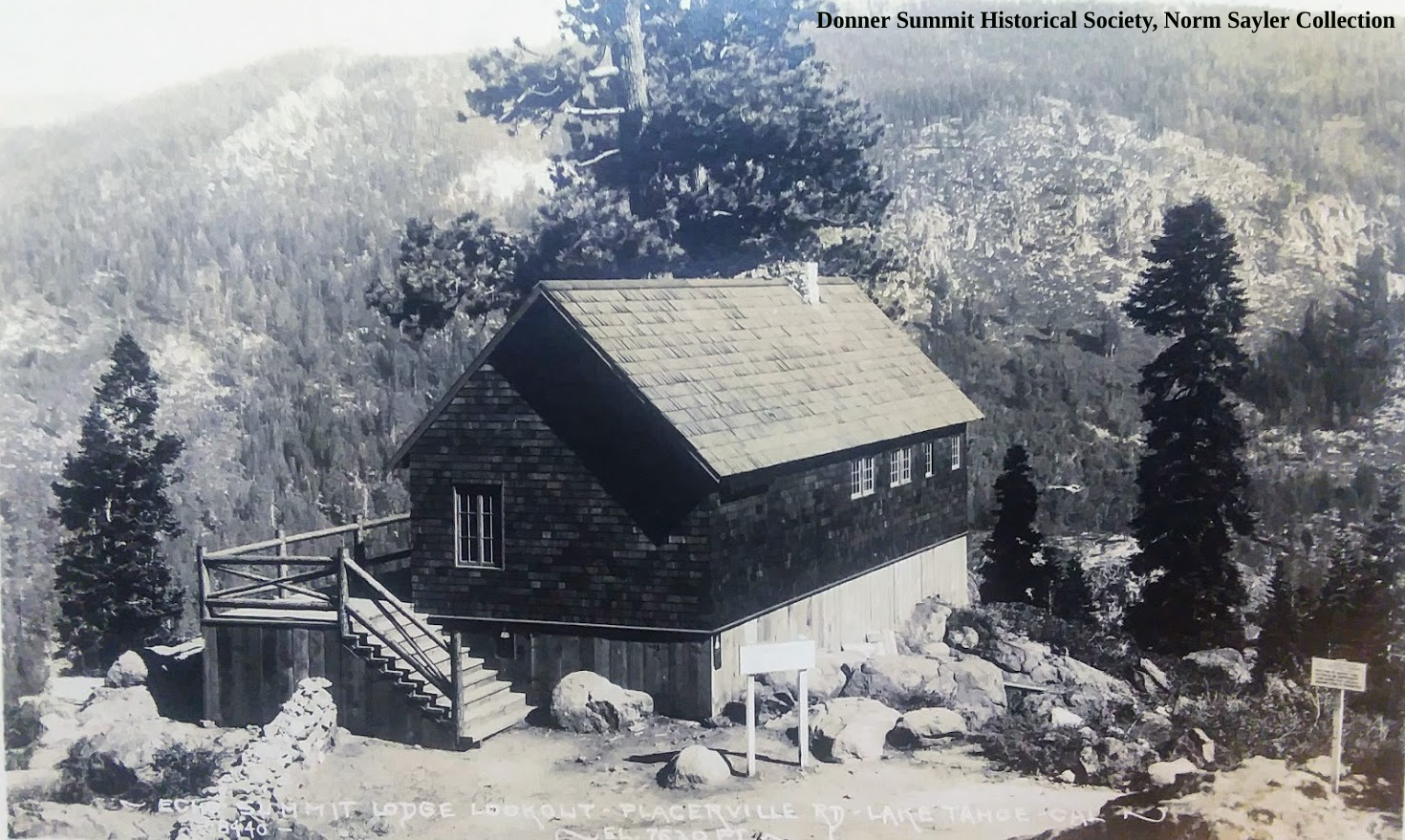
Eco Summit Lodge and Canteen at Johnson’s Pass.
The Lodge at Echo Summit, Lincoln Highway, Part 6
The early autoist would have finally reached Johnsons Pass after climbing up the steep Meyer’s Grade from the Tahoe Valley floor. These old autos would need supplies like water and oil once they reached the summit, as they were constantly leaking or burning up fluids. Fortunately, entrepreneur TC Wholbrick had built an early service station and food stop that he called a “Canteen.” We have talked about TC and his Canteens here. While there had been a small forest service cabin, TC added to it, creating the building we see in the above photo.
Inside of the Echo Summit Lodge and Canteen.
Above is a rare photograph of the inside of the Echo Summit Canteen. Everything seen in the photo was handmade by TC. Some of the furniture is inside the present Alpine Club Lodge, which occupies the site today.
The view from the Echo Summit Canteen, looking east.
While enjoying a break from the road, you could head to the deck in the back and check out the magnificent view, as seen above.
Once your supplies were purchased, you started back down the west slope of the Sierra Nevada. If you were a transcontinental autoist, having left New York weeks ago, this was your final mountain challenge on your way to San Francisco. The sign pictured below was just 100 yards beyond the Canteen, a popular spot to photograph your passengers and auto.
Summit of the Sierra Nevada Mountains, Johnson’s Pass, Echo Summit, El Dorado County.
In the photo below, we look back at the lodge as we head down the west slope of our journey on the Lincoln Highway. You can see a Lincoln Highway sign in the tree on the right.
Looking east at the Echo Summit Lodge and Canteen.
Below is the official Lincoln Highway map showing the location and features. To see the entire interactive map, go here.
