American River

Slippery Ford on the Lincoln Highways southern route, Part 4

When it comes to California history, Slippery Ford is a name and place that conjures up a terrifying chapter in transportation history. The name suggests that this river “ford” or crossing was dangerous. Indeed, until a bridge was built nearby, travelers would have to cross this portion of the American River by wading through, depending on the season, a shear film or torrent of cascading water. One slip and you and your wagon would slide down the river to a doubtful, likely painful outcome.

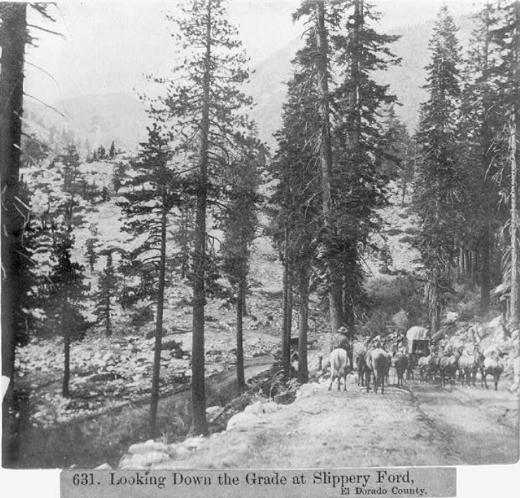
A wagon team and riders make their way down the grade from Sayle’s Flat towards Slippery Ford, 1866. Photo from the Library of Congress.

A wagon team and riders make their way down the grade from Sayle’s Flat towards Slippery Ford, 1866. Photo from the Library of Congress.

Before the Lincoln Highway passed this way, John Calhoun Johnson built what was known as Johnson’s Cut-Off Trail in 1852, which brought emigrants over the Sierra Crest. This route soon replaced the earlier Carson River emigrant route up and over Carson Pass to the south, a more difficult climb and a higher elevation. Johnson’s Cut -Off Trail soon became the road to use.

Another 1866 photo showing the wagon train headed up the grade. The photo was taken at the horseshoe bend as located on the map at the end of the post. Photo: Library of Congress.

Another 1866 photo showing the wagon train headed up the grade. The photo was taken at the horseshoe bend as located on the map at the end of the post. Photo: Library of Congress.

Something to keep in mind when exploring Slippery Ford, is there are two Slippery Fords just a few hundred yards from each other. The original crossing was the Johnson Cut-Off Trail which crosses Pyramid Creek, not the American River as the later Slippery Ford does. I will admit, that until I learned this it was a bit confusing reading the records of this area. One crossed Pyramid Creek, the other the American River.

Perhaps a Swan-Henry toll road bridge crossing the river near Slippery Ford. Photo:Library of Congress.

Perhaps a Swan-Henry toll road bridge crossing the river near Slippery Ford. Photo:Library of Congress.

As traffic increased tolls were collected to help find a new trail with the Slippery Ford Grade down to Strawberry being rebuilt by George W. Swan. It’s Swan’s brand new 1866 grade we are seeing in the above photos. The bridge at Snow Slide Mountain could be the first bridge built here in 1858. Both Slippery Fords are shown on the map at the end of the post.

One of the twin bridges that once crossed the American River at Slippery Ford.. Photo from: Lincoln Highway Association collection.

One of the twin bridges that once crossed the American River at Slippery Ford.. Photo from: Lincoln Highway Association collection.

As we have learned, the original 1913 alignment of the Lincoln Highway followed old wagon roads, and this was the case here. The Lincoln Highway followed the Swan-Henry toll road, with the addition of two bridges, or “twin bridges” that crossed the American River. The bridges were not side by side, but rather one went to a island while the other bridge exited the island. In the photo above we see an early auto on one of those bridges.

The following two video show us the first Slippery Ford of Johnson’s Pass over Pyramid Creek. This was the original emigrant trail that was later bypassed by the Swan-Henry Toll Road.

The following video gives you a good view of the area around Slippery Ford. One correction to the video. I mention we are on the ”Scenic Route” of the Lincoln Highway, but this is actually known as the “Pioneer” or southern route of the Lincoln. The Slippery Ford in this video is the later one used after Johnson’s Cut-Off Trail ford.

Once travelers crossed the American River, the road continues down the grade past Register Rocks, Lovers Leap, and into Strawberry. We’ll cover that part of the adventure in our next post of the El Dorado County section of the Lincoln Highway, Part 4.

Map of location and features discussed, Click map for larger view.

Map of location and features discussed, Click map for larger view.

Georgetown Divide History Tour, Part 3

We continue our tour of the historical side of The Georgetown Divide. During our last stop, we viewed the old Meyer's Dance Hall and Saloon, located in Uniontown, now known as Lotus. You can find that post here. Leaving Beach Street and turning left onto Highway 49, let's head to the site of Michigan Flat, located in today's Bacchi land, home of a local ranching family.

The Georgetown Divide History tour

The above map is interactive. You can zoom in and out to get a closer view. Click the orange boxes for more info on a particular site. To enlarge the map click the square at top right.

Michigan Flat is famous for being the site of one of the Stanford Brothers stores. Leland and Thomas kept a couple of stores in the gold country, with Thomas manning the one in Michigan Flat. One of the stones that made up the building still exists, supposedly in front of one of the homes in this area. For many years it was a feat to try and lift this stone. I wonder if it still exists?

Amos Bowman’s 1873 map of the Georgetown Divide. Interactive version here.

Amos Bowman’s 1873 map of the Georgetown Divide. Interactive version here.

In the above 1873 map, we can see Michigan Flat as well as what appears to be an old river crossing near Greenwood Creek. These river fords were common, as the dams upriver hadn't been built, so in summer and fall, the water levels would drop so one could ford these rivers. Another interesting spot on the map is a town called Powningville, of which I can find no information, altho it's quite prominent on the map.

Michigan Flat consisted of several smaller mining camps with names like Red Hill, Coyote Diggins, and Rich Gulch. Before the Stanford Brothers built their store, Charles Smith had the first store in Michigan Flat, in a tent located at the location where Greenwood Creek empties into the south fork of the American River. We have marked his store site on the map. A man named Tutsbury built a butcher shop, hotel, and boarding house where drink cost fifty cents! Wentzel Stock had the first bakery. On the flat itself, Charles Dusenberg was the first merchant in 1850 with his canvas shop. The Stanford brothers then built their shop, while John Hass kept the watch at his store. Jack Miller kept three more boarding houses and a bakery, while Dr's. Stone and Wheelock were the town's physicians.

1868 Township and county Map. Interactive version here.

1868 Township and county Map. Interactive version here.

In the above earlier map, from 1863, we see no mention of Powningville, but we do know the site of the old Magnolia Hotel in both charts. This old building was still standing in 1915. We have marked the possible location on our tour map. Also, I have included a shot of the potential site from Google Earth. Is this the old Magnolia Hotel site? Also of interest in the 1868 map is the site of the home of J.W. Marshall, Discoverer of Gold. This possible Magnolia House site is on private property, and please respect.

Ever wonder why the Bureau of Land Management trail-head nearby is called, Magnolia Ranch? Now you and I know. The old Magnolia House.

Is this the Magnolia House site?

Is this the Magnolia House site?

Powningville is quite a mystery. We have marked where we think the town stood on our map. You can compare it with the 1873 Amos Brown Map above. There is little to no reference to this town, other than the map. The other aspect of Powningville that I find interesting is the road titled, “Coloma Trail” that takes off from that town, roughly parallelling Highway 49 towards Cool. Powningville was close to the Fairmont Copper Mines, which according to the 1866 report by D.V. Whiting, Esq, also contained large blocks of the mineral garnet.

The old Coloma Trail, long gone.

The old Coloma Trail, long gone.

To continue our historical tour of The Georgetown Divide we continue north on Highway 49 towards the old town of Pilot Hill. We will cover that section in our next tour post. The map of the tour can be found in our maps section, here.

Rattlesnake Bar Bridge site

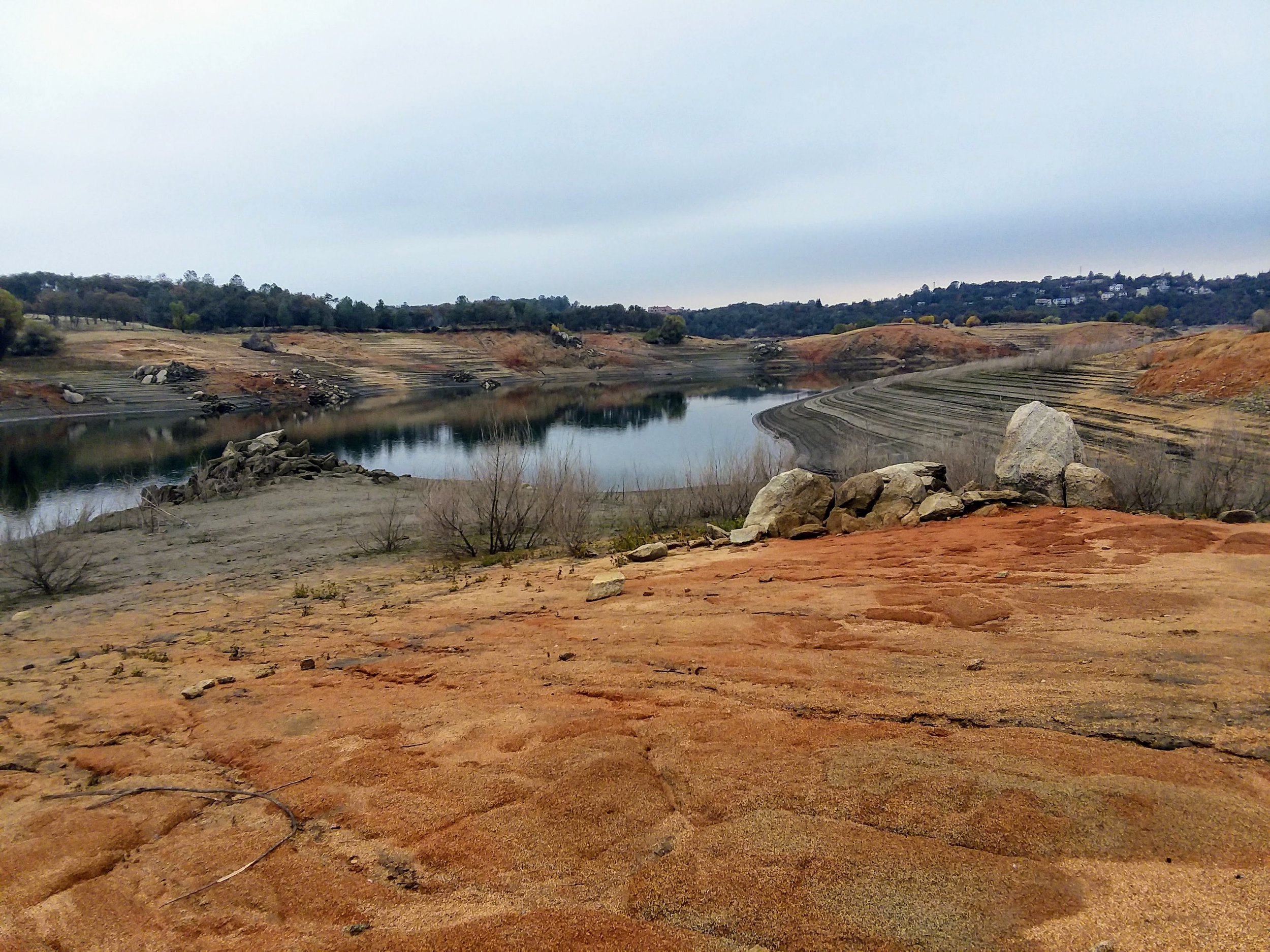
Wanting to keep our trip closer to home this time, we took a quick ride to Folsom Lake. We wanted to see the old Rattlesnake Bar Bridge site, which once forded the north fork of The American River, long before Folsom Dam. When the lake is filling or filled, this area is flooded by at least 50 feet of water. The lake had left lines in the sides of the hills, and old signs of hydraulic mining along with tailings added to the weird but beautiful landscape.

Folsom Lake at low levels, Rattlesnake Bar.

Folsom Lake at low levels, Rattlesnake Bar.

We rounded a corner to see the pilings for the bridge fully exposed! We knew what they looked like from earlier photos taken during our last drought, but it's fun to see them in person. It reminds us that there were quite a few active communities located in the ravines and channels that would become Folsom Lake. Rattlesnake Bar was one such place, a town that grew because of gold, burned down, then built again just a little way up the hill. We had heard that Rattlesnake Bar was on the El Dorado County side, but this map from 1873 shows Rattlesnake Bar on the Placer County side. You can also see the bridge crossing the narrow north fork Channel and Wild Goose's old town site on The El Dorado County side. Another map from 1910, The American River Canal Map, also shows Rattlesnake Bar on the Placer County side.

1873 map of The Georgetown Divide

1873 map of The Georgetown Divide

While gold was the main impetus for creating Rattlesnake Bar in the 1850s, the bridge facilitated the transportation of agricultural products and quicklime from the Alabaster Cave Quarry on the El Dorado County side. It was William Gwyn, discoverer of the famous Alabaster Caves, or at that time called Coral Caves, who built the first bridge in 1863. This cave was the result of a search for lime to use in the lime kiln nearby. Quicklime was created and then transported across this bridge. The Alabaster Cave soon became a tourist attraction, and the bridge helped interested people get there more quickly. You could take the train from Sacramento to Auburn, then a stage to the bridge, where you would cross to the El Dorado side and the extraordinary Alabaster Cave. We will talk about this then famous cave in a later post.

Sacramento Daily Union, Volume 25, Number 3835, 7 July 1863

Sacramento Daily Union, Volume 25, Number 3835, 7 July 1863

The original wooden bridge, built-in 1862, was replaced with a wire suspension bridge that endured until it collapsed in 1954 under an overloaded truck's weight. Folsom Dam was under construction, and this area would soon be underwater, so the counties did not replace the bridge.

Rattlesnake Bar Bridge, 1860 or 1870’s. Notice the young child just to the left of the man standing.

Rattlesnake Bar Bridge, 1860 or 1870’s. Notice the young child just to the left of the man standing.

The same spot today with the bridge pilings clearly visible.

The same spot today with the bridge pilings clearly visible.

Here is a short video concerning our trip to the bridge site.