Strawberry

Slippery Ford on the Lincoln Highways southern route, Part 4

When it comes to California history, Slippery Ford is a name and place that conjures up a terrifying chapter in transportation history. The name suggests that this river “ford” or crossing was dangerous. Indeed, until a bridge was built nearby, travelers would have to cross this portion of the American River by wading through, depending on the season, a shear film or torrent of cascading water. One slip and you and your wagon would slide down the river to a doubtful, likely painful outcome.

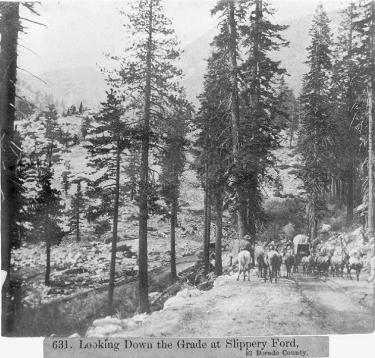
A wagon team and riders make their way down the grade from Sayle’s Flat towards Slippery Ford, 1866. Photo from the Library of Congress.

A wagon team and riders make their way down the grade from Sayle’s Flat towards Slippery Ford, 1866. Photo from the Library of Congress.

Before the Lincoln Highway passed this way, John Calhoun Johnson built what was known as Johnson’s Cut-Off Trail in 1852, which brought emigrants over the Sierra Crest. This route soon replaced the earlier Carson River emigrant route up and over Carson Pass to the south, a more difficult climb and a higher elevation. Johnson’s Cut -Off Trail soon became the road to use.

Another 1866 photo showing the wagon train headed up the grade. The photo was taken at the horseshoe bend as located on the map at the end of the post. Photo: Library of Congress.

Another 1866 photo showing the wagon train headed up the grade. The photo was taken at the horseshoe bend as located on the map at the end of the post. Photo: Library of Congress.

Something to keep in mind when exploring Slippery Ford, is there are two Slippery Fords just a few hundred yards from each other. The original crossing was the Johnson Cut-Off Trail which crosses Pyramid Creek, not the American River as the later Slippery Ford does. I will admit, that until I learned this it was a bit confusing reading the records of this area. One crossed Pyramid Creek, the other the American River.

Perhaps a Swan-Henry toll road bridge crossing the river near Slippery Ford. Photo:Library of Congress.

Perhaps a Swan-Henry toll road bridge crossing the river near Slippery Ford. Photo:Library of Congress.

As traffic increased tolls were collected to help find a new trail with the Slippery Ford Grade down to Strawberry being rebuilt by George W. Swan. It’s Swan’s brand new 1866 grade we are seeing in the above photos. The bridge at Snow Slide Mountain could be the first bridge built here in 1858. Both Slippery Fords are shown on the map at the end of the post.

One of the twin bridges that once crossed the American River at Slippery Ford.. Photo from: Lincoln Highway Association collection.

One of the twin bridges that once crossed the American River at Slippery Ford.. Photo from: Lincoln Highway Association collection.

As we have learned, the original 1913 alignment of the Lincoln Highway followed old wagon roads, and this was the case here. The Lincoln Highway followed the Swan-Henry toll road, with the addition of two bridges, or “twin bridges” that crossed the American River. The bridges were not side by side, but rather one went to a island while the other bridge exited the island. In the photo above we see an early auto on one of those bridges.

The following two video show us the first Slippery Ford of Johnson’s Pass over Pyramid Creek. This was the original emigrant trail that was later bypassed by the Swan-Henry Toll Road.

The following video gives you a good view of the area around Slippery Ford. One correction to the video. I mention we are on the ”Scenic Route” of the Lincoln Highway, but this is actually known as the “Pioneer” or southern route of the Lincoln. The Slippery Ford in this video is the later one used after Johnson’s Cut-Off Trail ford.

Once travelers crossed the American River, the road continues down the grade past Register Rocks, Lovers Leap, and into Strawberry. We’ll cover that part of the adventure in our next post of the El Dorado County section of the Lincoln Highway, Part 4.

Map of location and features discussed, Click map for larger view.

Map of location and features discussed, Click map for larger view.

Strawberry House, there were two locations.

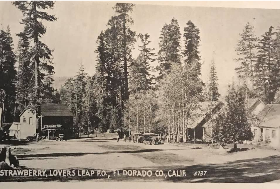
Driving up to Lake Tahoe on Highway 50, the Strawberry Lodge has been greeting visitors since Fred Baumhoff built it in 1939. What about the Strawberry House that greeted earlier travelers along the Swan-Henry Toll Road? Where Mr. Berry built the first Strawberry House has been a mystery to me. Perhaps someone in this group has the answer?

The third Strawberry House built in 1939 next to the present day Highway 50. UC Davis photo, Eastman collection:

The third Strawberry House built in 1939 next to the present day Highway 50. UC Davis photo, Eastman collection:

The present Highway 50 was built in the mid-1930s, bypassing the old Swan-Henry toll road, which also saw service as the first state highway, The Placerville-Lake Tahoe Wagon Road, then as the Lincoln Highway from 1914 to 1928, and finally an early version of Highway 50. It was along the old road that Irad Berry built the first two incarnations of the Strawberry House, the second after the first burned down. It was along this route that travelers would have to cross the fabled "Slippery-Ford" across the American River at TwinBridges. Once you forded the river, the next stop was the "Slippery Ford House," past Hank Monk Rock, and finally Strawberry House.

The Strawberry Valley House along the Swan-Henry Toll Road.

The Strawberry Valley House along the Swan-Henry Toll Road.

Where was the first Strawberry House located? Looking at a couple of older pictures, we see the sight appears much closer to "Lovers Leap" than it sits today, which makes sense since the old road passed directly under the famous cliff.

Here is a map showing the new and old roads up to Twin Bridges. The new Highway 50 of the mid-1930s is the blue line, which is the same route we follow today. The red line is the old road, which followed a course next to Lovers Leap.

screenshot-www.google.com-2019.11 (21).png

The following map is a close up in satellite view. As you can see, the old road, red line, emerged onto the area that is present-day Highway 50. The question I have is, did the old way follow the green path down Strawberry Lane, crossing the river further downstream, or did it follow the pink line, crossing the river before the Strawberry House?

Close up of the different roads.

Close up of the different roads.

The photograph below shows a series of small cabins that were part of the Strawberry Resort during the Lincoln Highway era. Where were these cabins located along the road?

1920 Mc Carthy Photograph showing the cabins at Strawberry. Photo from: Calif. State Archives.

1920 Mc Carthy Photograph showing the cabins at Strawberry. Photo from: Calif. State Archives.

The photograph below is from 1903, showing a stagecoach leaving Strawberry. Notice how close Lovers Leap is in the background. Where was this located along the old road? Where was the original Strawberry House? The only clues I have are the new 1939 building was built closer to the new highway, at least a few hundred yards west of the original.

1903 photograph shows an open stagecoach with "Lake Tahoe Placerville" printed on the side, men and boy standing in front, barn or stable in background. Photo from: California State Archives

1903 photograph shows an open stagecoach with "Lake Tahoe Placerville" printed on the side, men and boy standing in front, barn or stable in background. Photo from: California State Archives