• Blog
  • Historic Photos
  • About
  • Search
  • Resources
  • Contact Us
  • Menu

Adventures in California History

  • Blog
  • Historic Photos
  • About
  • Search
  • Resources
  • Contact Us

Sign up!

You can receive our posts sent directly to your e-mail inbox.

We respect your privacy.

Thank you!
1910 horse/mule train near Auburn Ca. Photo: Placer County Museums

1910 horse/mule train near Auburn Ca. Photo: Placer County Museums

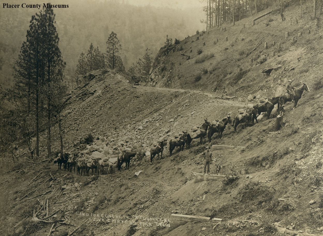
Horse team carrying sand for the construction of the Mountain Quarries Railroad

January 30, 2021 in El Dorado County History, Georgetown Divide History, Placer County History

The Mountain Quarries Bridge and railroad were built in 1912 to bring limestone from the quarry to nearby Auburn. The construction that took place when animals worked alongside early 20th Century machines documented with this photo.

This photo looks like a mixed "pack train" of horses and mules. They are hauling sand for making concrete with teamster Charles Ray (on the lead horse). I counted 14 horses/mules, three men, and a dog, which can be seen in the close-up below.

A horse-mule pack train near Auburn and the Mountain Quarries Bridge, 1910. Photo from: Placer County Museums.

A horse-mule pack train near Auburn and the Mountain Quarries Bridge, 1910. Photo from: Placer County Museums.

This spot looks familiar as we have hiked the Mountain Quarries Trail before. The concrete foundations seen in the photo are for a railroad trestle crossing, but not the Mountain Quarries Bridge. There are 17 places along the old railbed where they built trestles over canyons and sides of hills. We will try and take a photo of this spot next time we hike the trail.
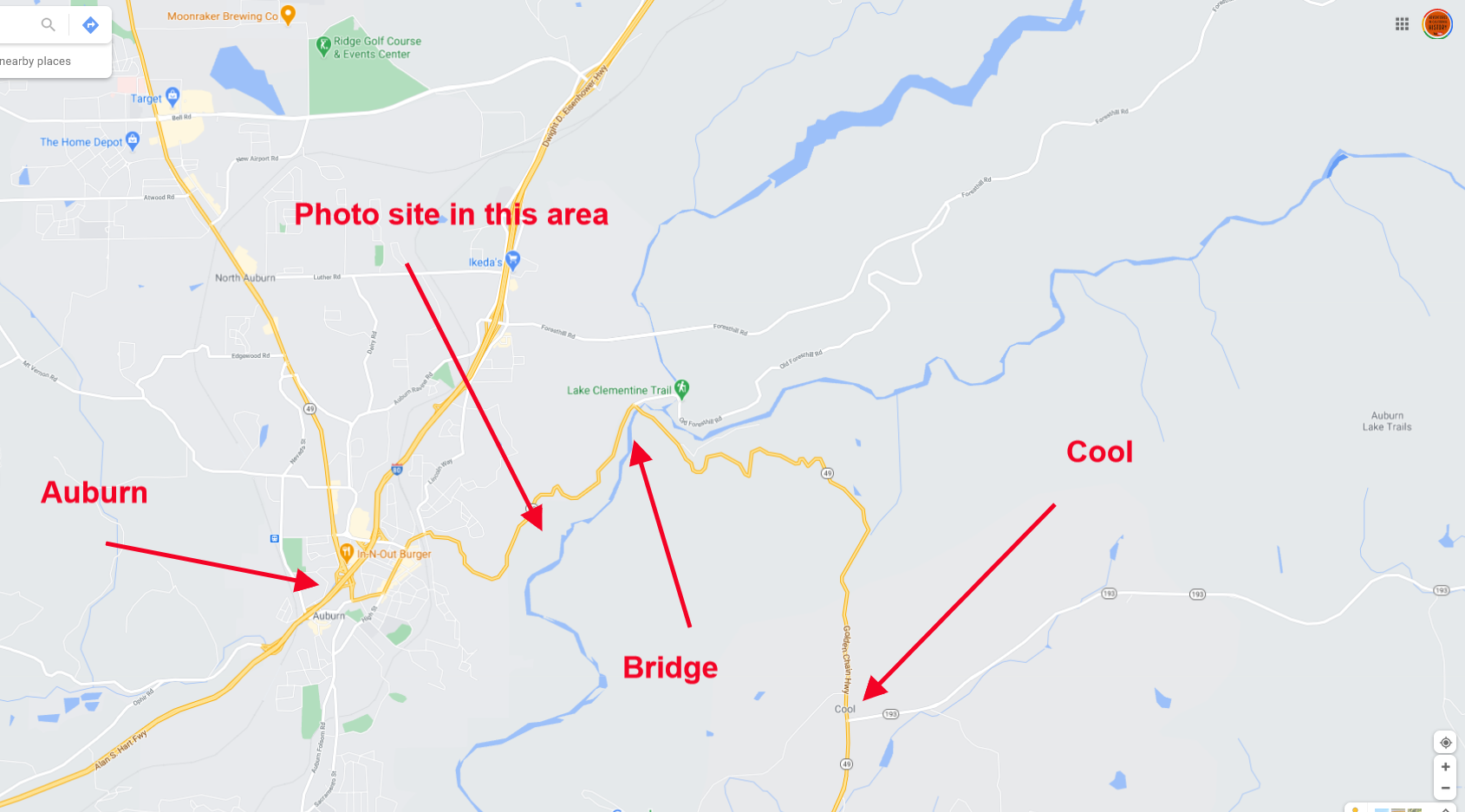
Map of the area. Click to see a closer view.

Map of the area. Click to see a closer view.

Tags: Auburn, Cool, El Dorado County, Placer County, railroad, quarry, Highway 49, limestone, narrow gauge railroad, Georgetown Divide
Comment
Monica walking a section of the old Rattlesnake Bar Road.

Monica walking a section of the old Rattlesnake Bar Road.

Rattlesnake Bar Road and Bridge site

January 28, 2021 in Georgetown Divide History, El Dorado County History, Placer County History

Folsom Lake has receded enough that artifacts the lake submerged over 70 years ago are visible once again. We have explored the site of the Rattlesnake Bar Bridge before. On this visit, we also walked the old road section that had made an appearance since the water has receded. We had wondered about the route of the road and how it made its way to the bridge. A wonderful section of the road is quite visible, as seen in the photo above. This is facing away from the bridge site, headed away from the bridge.

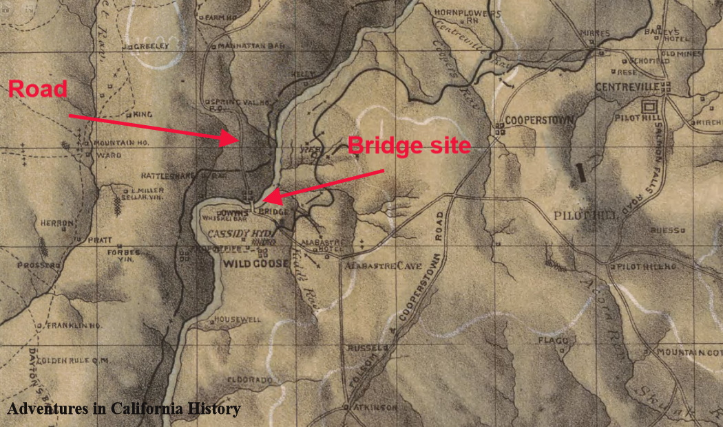
1873 map of the Georgetown Divide showing the bridge site and road. Click map for a larger view.

1873 map of the Georgetown Divide showing the bridge site and road. Click map for a larger view.

Rattlesnake Bar Road was a well used crossing of the American River all the way up to the lake filling in 1955/56. This was an easy way to cross the river and access Pilot Hill headed east or Auburn headed north west. Once the lake was filled this old crossing was inundated and the road on the El Dorado County side was changed to Goose Flat Road, still a county road, though not maintained and on now private land.

Bridge foundations on either side of the north fork of the American River. Looking from Placer County.

Bridge foundations on either side of the north fork of the American River. Looking from Placer County.

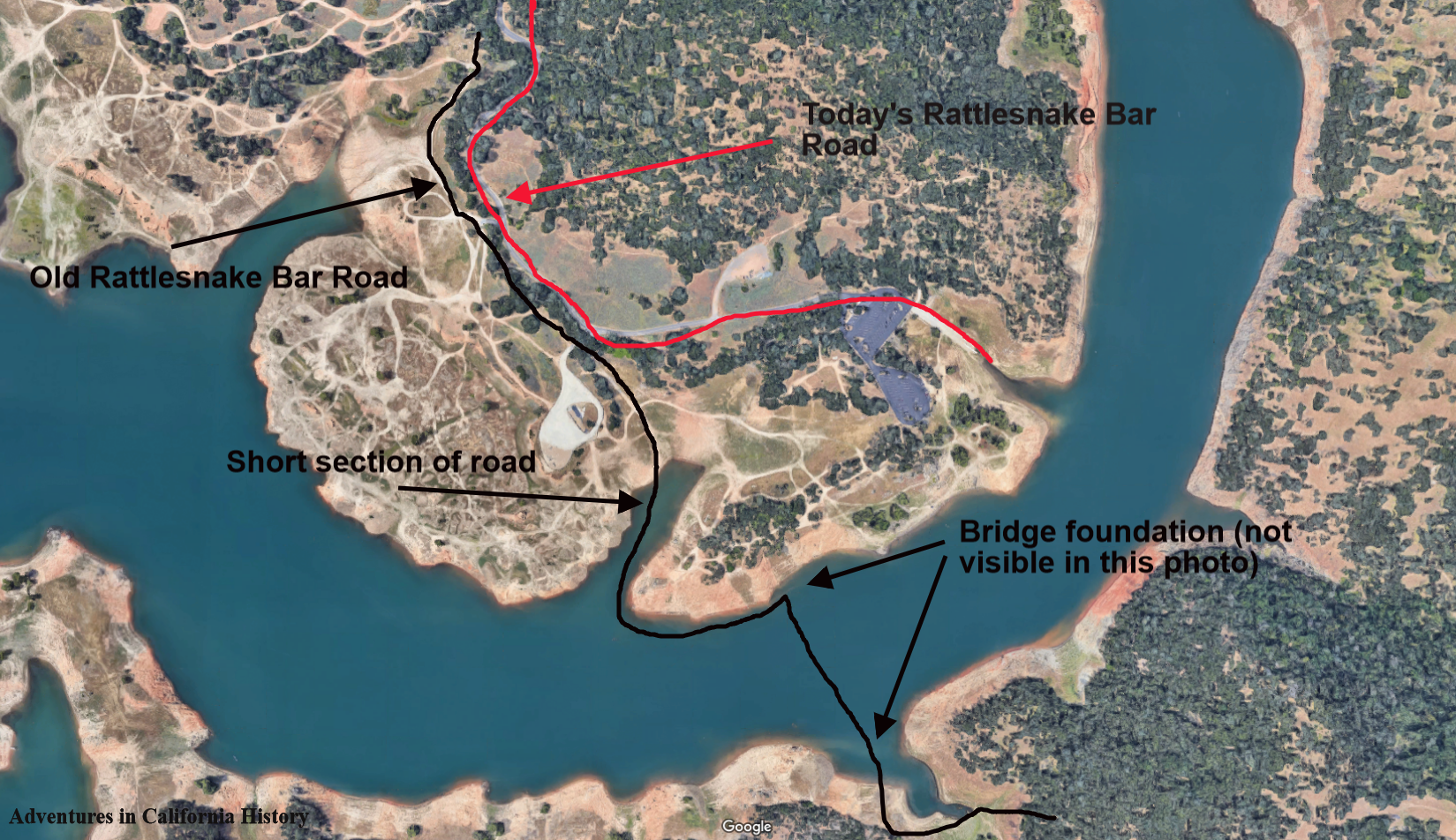
The above photo is from the Placer County side and shows the two foundations on either side of the river. The lake was low enough on the day we visited that the Placer County side's road is visible and shows the approach to the bridge site. The old road does not follow the present-day Rattlesnake Bar Road into the state park where the bridge stood but follows its own course, hidden from view most of the time. Below is a section we found covered with asphalt.

Rattlensake Bar Road arrows.png

We have located the short sections of the road in the photo on the map below. You can also see the bridge foundation locations from this satellite photo, though the lake submerges both.

Click map for a closer view.

Click map for a closer view.
We enjoyed checking out the surreal landscape of a low Folsom Lake. All of the area around Folsom Lake was mined by gold seekers during the 19th and early 20th Centuries. That with the rising and lowering of the reservoir has created an otherworldly landscape with multiple levels of dirt of different colors. Quite striking and combined with the history of the area makes for a great day trip.

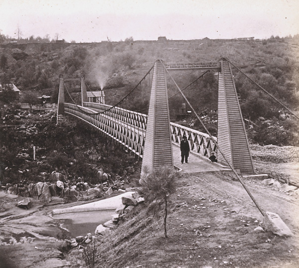
Below is a photograph of the old bridge. There is a man and a boy in the photograph along with smoke coming out of the bridge tenders shack. The printing above the man reads, “All persons driving or riding faster than a walk over this bridge will be fined to the extent of the law.”

The Rattlesnake Bar Bridge, 1860s to 1870s. Can you see the child in the photo?

The Rattlesnake Bar Bridge, 1860s to 1870s. Can you see the child in the photo?

Tags: Placer County, El Dorado County, bridges, Rattlesnake Bar, roads, Folsom Lake
1 Comment
Quonset Hut Motel on Highway 40, just outside Colfax. Click the  photo for closer view. Photo: Placer County Museums.

Quonset Hut Motel on Highway 40, just outside Colfax. Click the photo for closer view. Photo: Placer County Museums.
The Quonset Hut Motel near Colfax

January 16, 2021 in Lincoln Highway, Placer County History

The Quonset Hut Motel just outside of Colfax was built right after WWII when war surplus Quonset Huts were made available to the public. They became quite popular for all sorts of buildings as they could be gotten fairly cheap and were quite portable, as the photo below shows.

Quonset Hut being installed in Japan just after the end of WWII.

Quonset Hut being installed in Japan just after the end of WWII.

Quonset is a name for a small town in Rhode Island, where the military manufactured the huts for the WWII war effort. . Quonset is an Algonquian word meaning "small, long place."

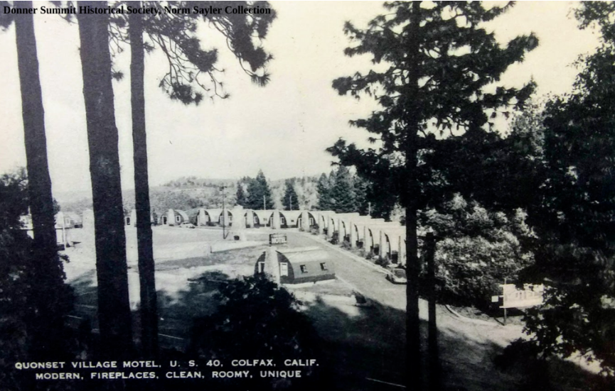
Over the years, Quonset Huts were used for many different types of business and even as homes. In this case, a motel was developed, taking advantage of the huts. The photo at the top of the post looks to be just before the later one taken below. The large Quonset in the first photo seems to be missing in the bottom photo, though the rock chimneys seem to be standing.

A different view of the Quonset Hut Motel. Photo: Donner Summit Historical Society, Norm Sayler Collection.

A different view of the Quonset Hut Motel. Photo: Donner Summit Historical Society, Norm Sayler Collection.

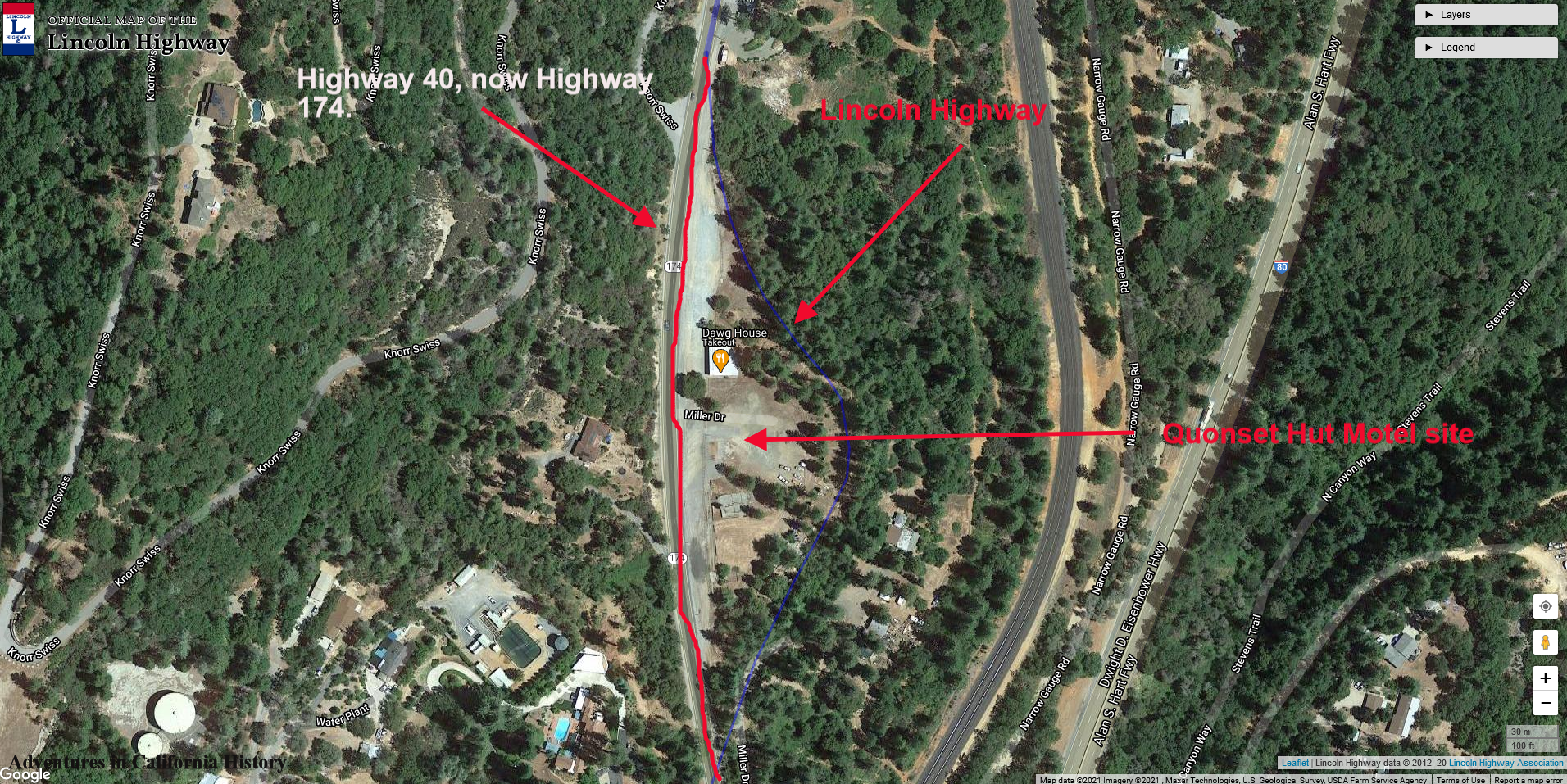
Map of the site. Click the map for a closer view.
Map of the site. Click the map for a closer view.

Today there is only one Quonset Hut left. The site can be visited by heading north from Colfax on Highway 174. Interestingly, the Lincoln Highway, 1913 to 1927, took a course where the owner eventually placed the Quonset Huts. You can see the route on the bottom map. During the motel's existence, the newer Highway 40 passed straight in front of the site.

Quonset Hut Motel site today on Highway 174, Colfax.

Quonset Hut Motel site today on Highway 174, Colfax.

Tags: Quonset hut, Colfax, Lincoln Highway, Highway 174, Highway 40, 1940s, 1944, World War II, motel, Placer County, Sierra Nevada history
3 Comments
Monica is looking over the side of the Johnson-Cut-Off Trail, now known as Peavine Ridge Road. Check out the fabulous rock wall at right.

Monica is looking over the side of the Johnson-Cut-Off Trail, now known as Peavine Ridge Road. Check out the fabulous rock wall at right.

Brockliss Bridge site

January 14, 2021

Monica and I had wanted to visit the site of the old Brockliss Bridge for some time. We would pass by the crumbling buildings of Pacific House on Highway 50, and then the old Peavine Ridge Road down to the river would beckon.

Pacific House was a stop for weary travelers along Johnson’s Cut-Off Trail and later the county Placerville to Lake Tahoe Road, Lincoln Highway, and Highway 50.

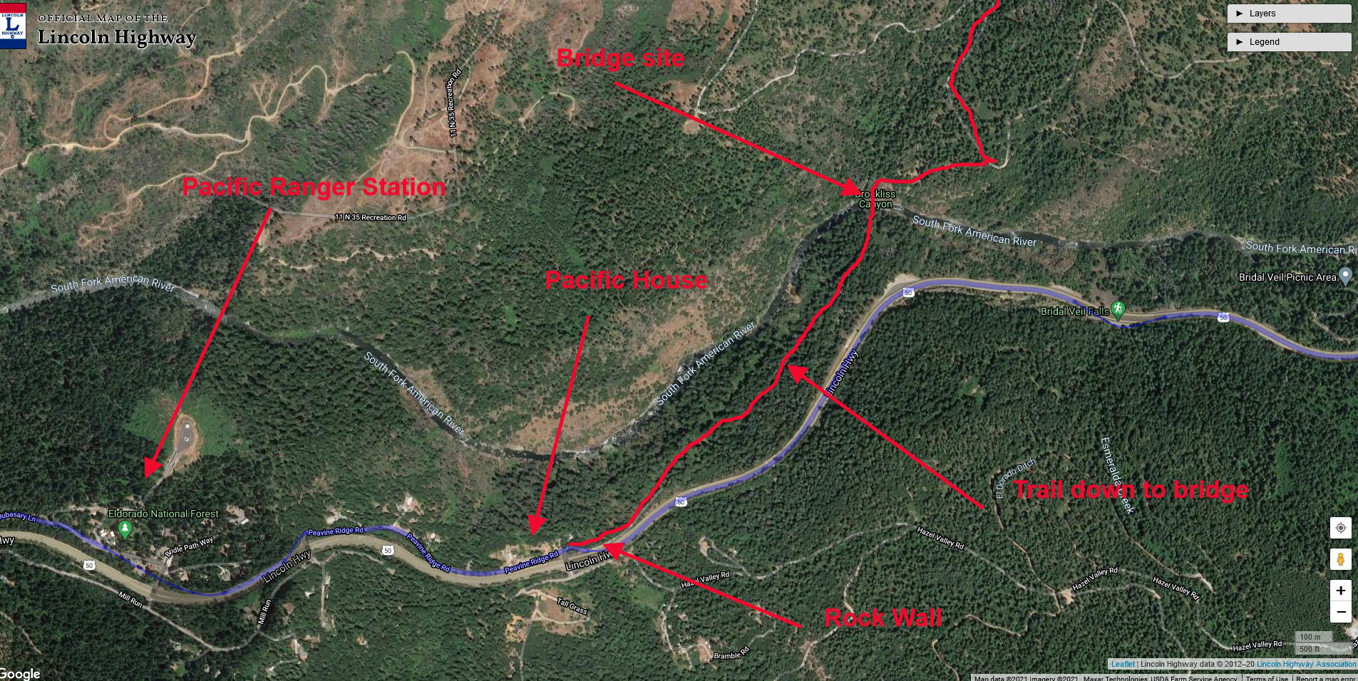
Leaving Pacific House and heading down Peavine Ridge Road, we came upon this magnificent block wall, pictured above, which seemed to have been built for the later roads that follow the Highway 50 route. This wall extends for a couple of hundred yards. The rock work seems to be the same type and era of other rock work we have seen along the county road's older sections. Likely this was built in the late 19th or early 20th Century.

Brockliss-Blair Bridge foundations. This was the third and last bridge located at this spot.

Brockliss-Blair Bridge foundations. This was the third and last bridge located at this spot.

It’s a steep grade down to the bridge site, and we imagined the countless teams of hoses and wagons that once climbed up this very hill on their way to the goldfields. When the 1859 Silver boomed commenced in Nevada, the traffic reversed course and headed down the grade as we are.

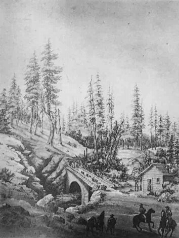
Here is a beautiful rendering of the old Brockliss Bridge and toll station during the heydays of its existence. It looks like this was looking west, from the south side of the river.

Here is a beautiful rendering of the old Brockliss Bridge and toll station during the heydays of its existence. It looks like this was looking west, from the south side of the river.

This spot along the river was a natural ford (crossing) of John C. “Cockeye” Johnson’s overland trail. In 1853, he built a bridge, but winter floods the following year washed it away. With all the traffic, it was becoming apparent that this spot needed a new bridge.

The state legislature funded a timber lock arch structure in 1855-56, built by Anthony Brockliss, at the cost of $11,300. That bridge, after considerable use, collapsed in 1869. No bridge crossed this spot for the next 60 years.

In 1929 the Blair Brother Lumber Company built a third bridge at the site, known as the Brockliss-Blair Bridge. Lumber trucks and others used this bridge until the Forest Service destroyed it after 60 years of service. The concrete foundations at each side of the river are from this last bridge. We could find no evidence of the earlier bridges.

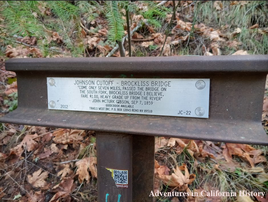
Trails West “T” Marker at the bottom of the grade at Pacific House.

Trails West “T” Marker at the bottom of the grade at Pacific House.

At the bottom of the grade, the Trails West group has installed one of their "T" markers with a pioneer's quote. John McTurk commented in 1859 on the fare, $1, and the steep climb up after crossing the bridge. Still a steep climb up!

It’s always enjoyable to walk these old trails and imagine what it was like in the “old days.” This road would have had so much traffic during its early existence that if you left the line, you might not be able to proceed until nightfall. Amazing! Today, other than in summer, when people head down to the swimming hole, you are likely the only people on this trail. It’s history, almost all but forgotten.

A map of the area and features. Click the map to make it larger.

A map of the area and features. Click the map to make it larger.

1 Comment
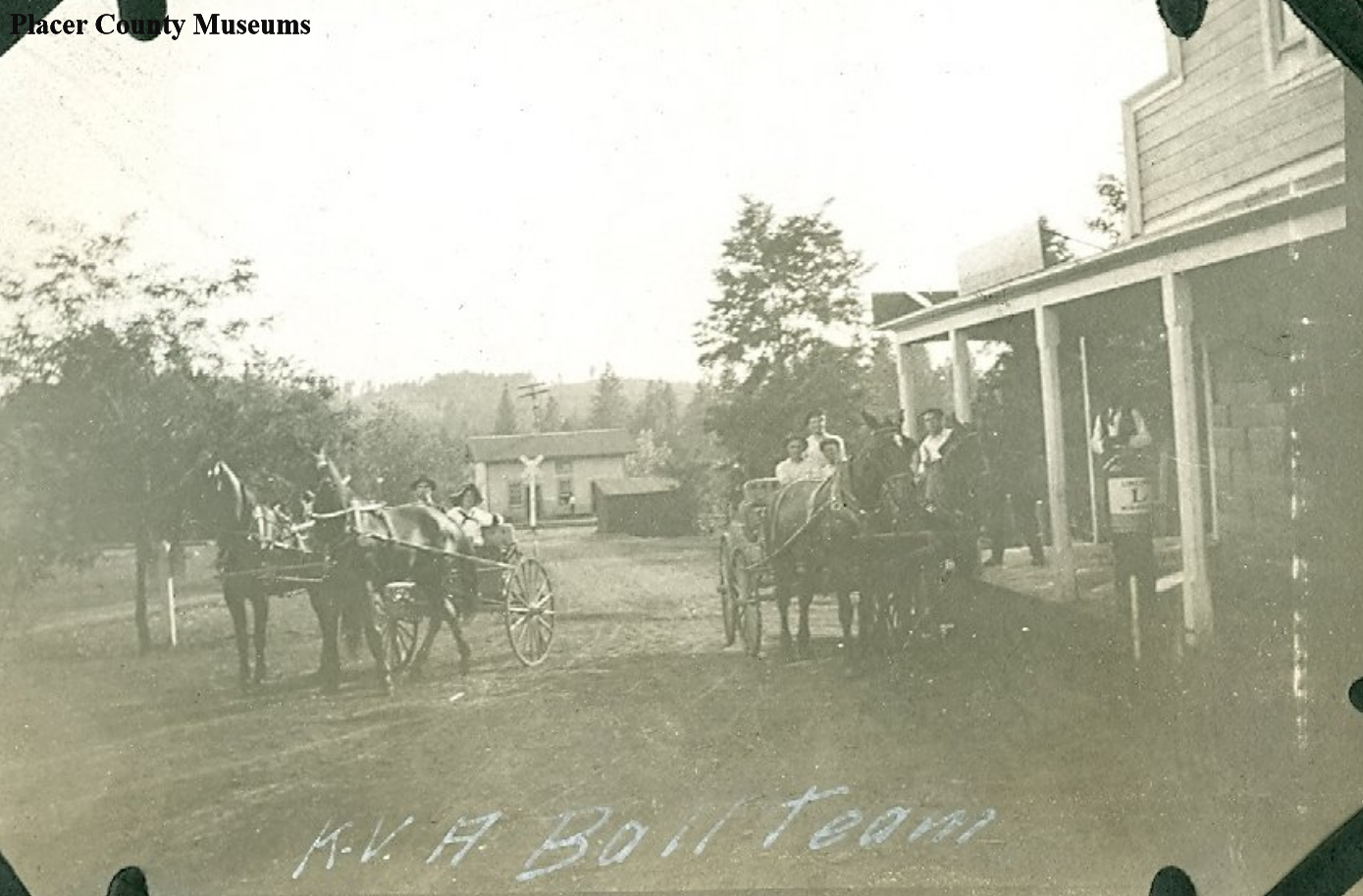
Horse and carriage were still popular well into the 20th Century. Note the Lincoln Highway “L” at right. Photo: Placer County Museums.

Horse and carriage were still popular well into the 20th Century. Note the Lincoln Highway “L” at right. Photo: Placer County Museums.

Alta and the Lincoln Highway

January 11, 2021 in Lincoln Highway, Placer County History, Sierra Nevada History

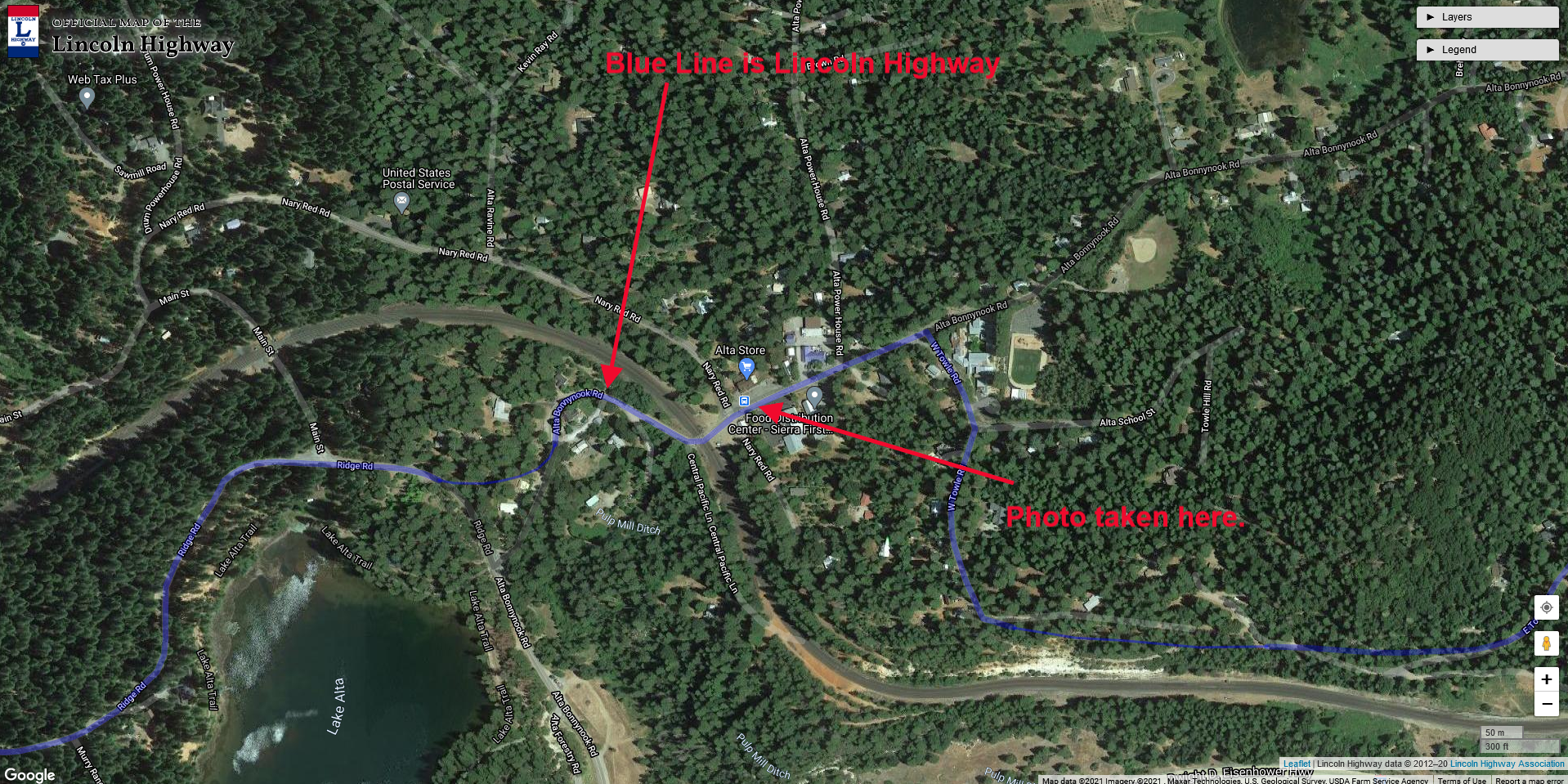
This photograph was taken in 1916 and showed the K.V.A. Ball Team in Alta, California. While we are not sure what the initials stand for, we are confident of the location. In the background, you can see a railroad crossing, which at this date would be the Southern Pacific Railroad. The building at right is the Alta Store, which still operates to this day.

Today’s Alta Bonny Nook Road was in 1916 the Lincoln Highway, which would have brought most transcontinental drivers right through the town. What’s fun about the above photo is a Lincoln Highway logo painted on a gas pump of some type. The Lincoln Highway Logo painted on telephone poles, bridges, and any other prominent spot was to help drivers navigate the country, and it would have been a central location in town. It was interesting to note no autos in the photo, but horses and buggies were still popular in the early 20th Century.

Map of location. Click photo for larger view.

Map of location. Click photo for larger view.

Tags: Alta, railroad, Placer County, Sierra Nevada history, horse and buggies, Lincoln Highway, Sierra Nevada History
Comment
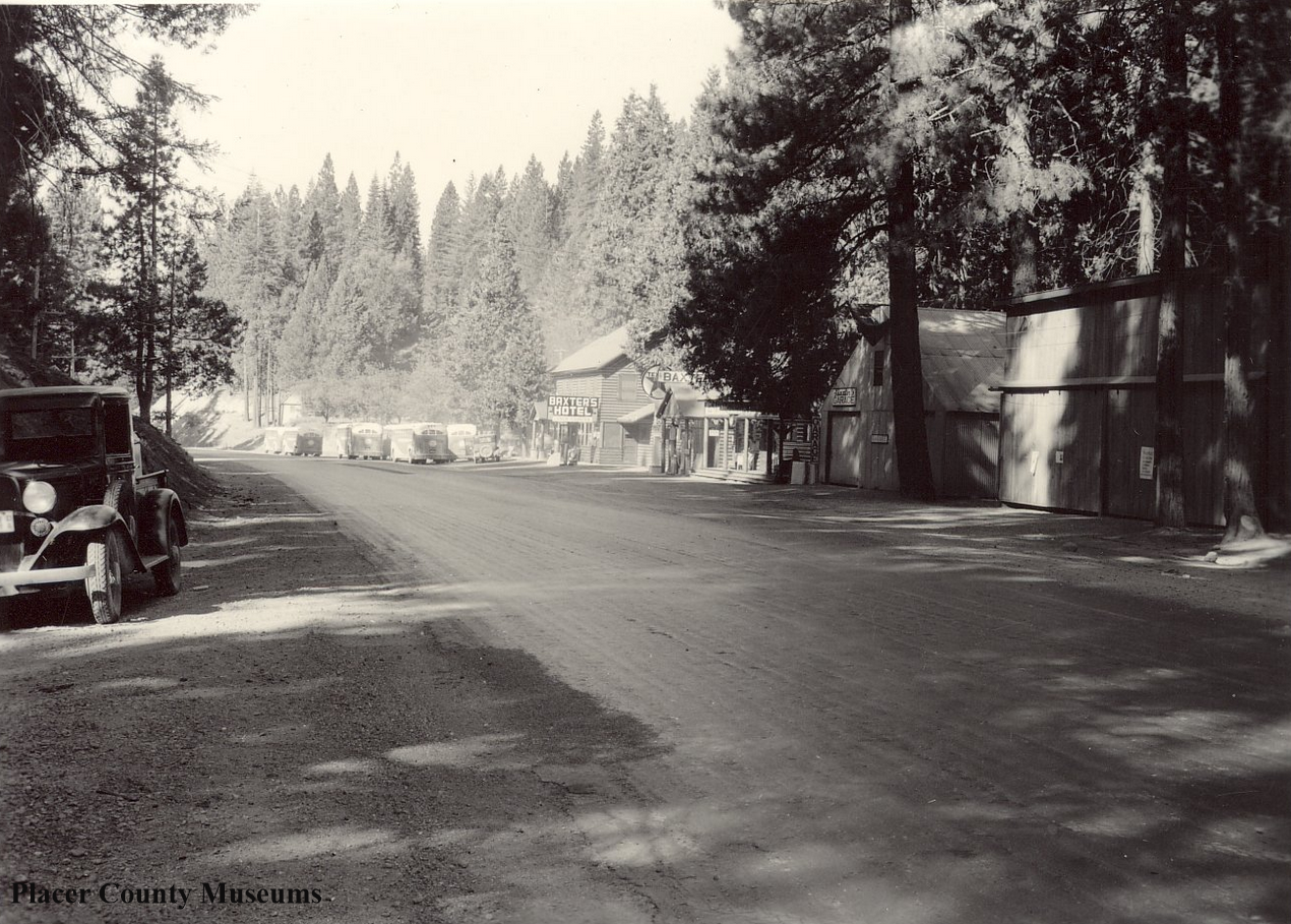
1936 photo showing about 6+ buses parked in front of Baxter’s Hotel. Photo: Placer County Museums.

1936 photo showing about 6+ buses parked in front of Baxter’s Hotel. Photo: Placer County Museums.

A busy day at Baxter along old Highway 40

January 10, 2021 in Lincoln Highway, Placer County History, Sierra Nevada History

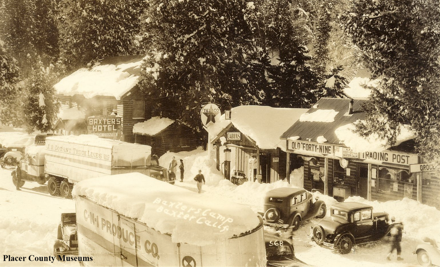
For many years, the mountain town of Baxter sat on the main transcontinental highway from Donner Summit to Auburn. Before the present Interstate 80 was built about 200 yards from this spot, everyone crossing the Sierra on Highway 40, the Lincoln Highway, stopped here to re-fuel and re-fresh. It's hard to imagine just how much traffic passed this way. These two photos help us to see the amount of traffic this small stop catered.

The above photo showed Baxter in 1936 when this was Highway 40. If you look closely down the road, there are at least 6+ buses parked in front of the Baxter's Hotel Lunch Counter. Figuring the buses were loaded with about 50 passengers, that means about 300 people are eating inside the building!

1926 photo showing trucks parked at Baxter, Placer County. Photo:Placer County Museums

1926 photo showing trucks parked at Baxter, Placer County. Photo:Placer County Museums

Now let’s go back ten years to 1926 when this road was the Lincoln Highway. It appears that two big rigs have decided to stop for supplies after having crossed the summit and made it down the grade. There are plenty of automobiles parked around the front of the buildings, all visiting the Lunch Counter at the hotel or buying supplies at the “Old Forty-Nine Trading Post.”

The photo below shows Baxter today, looking east instead of west, like the older photos. The concrete foundation for the gas pumps can still be seen down the road by that building. Everything else has disappeared. The building standing in the photo seems to be a supply point for trucks harvesting water from Crystal Springs, nearby.

Baxter, looking east. Not much left of the old town.

Baxter, looking east. Not much left of the old town.

Tags: Baxter, Placer County, buses, gas station, Highway 40, Lincoln Way, Sierra Nevada history
Comment
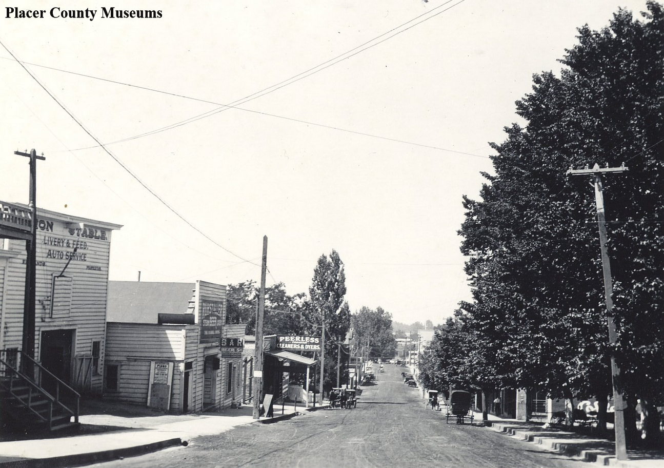
Looking down Railroad Street (The Lincoln Highway), Auburn, CA. Photo from Placer County Museums. Click photo for larger view.

Looking down Railroad Street (The Lincoln Highway), Auburn, CA. Photo from Placer County Museums. Click photo for larger view.

A summertime day in Auburn, 1916.

January 09, 2021 in Placer County History, Sierra Nevada History, Lincoln Highway

We were looking down Railroad Street from the Freeman Hotel, Auburn. To the left, we see a Livery, Feed, and Auto Service, which was a logical choice for the livery as the new automobile made its appearance. The horse and buggy were doomed and best to transition while the transcontinental highway passed in front. Railroad Street in 1916 was the Lincoln Highway, bringing people and autos from the rest of the country as far as New York.

There is a bar just further down, which, according to the sign out front, sold beer for 5 cents, and beyond the bar is the Peerless Cleaners and Dyers. Better enjoy that beer, as prohibition will begin in just a couple of years, 1919. Not a lot of traffic on what appears to be a summer day, as the trees a fully leafed out. It looks like the water wagon may have passed by recently, keeping that nicely graded roadbed from becoming dust.

Interesting to note that people still used horses and wagons in 1916, as the first three vehicles we see are buggies. I do think we can see a couple of auto’s further down the road.

World War I is raging in Europe, and many of the hometown boys are off fighting. When the soldiers that survived return, everything will change as we transition from one era to another, the roaring 20’s!

Tags: Lincoln Highway, Auburn, horse and buggies, 1916, 1910s, livery, auto, Lincoln Way, Railroad Street, cleaners, California history
Comment
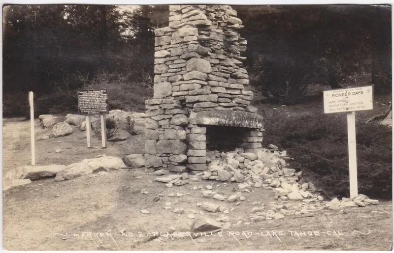
T.C. Wohlbruck photo showing the remains of the chimney at the Georgetown Junction.

T.C. Wohlbruck photo showing the remains of the chimney at the Georgetown Junction.

Georgetown Junction, historic crossroads along the Lincoln Highway

January 08, 2021 in Lincoln Highway, El Dorado County History, Sierra Nevada History
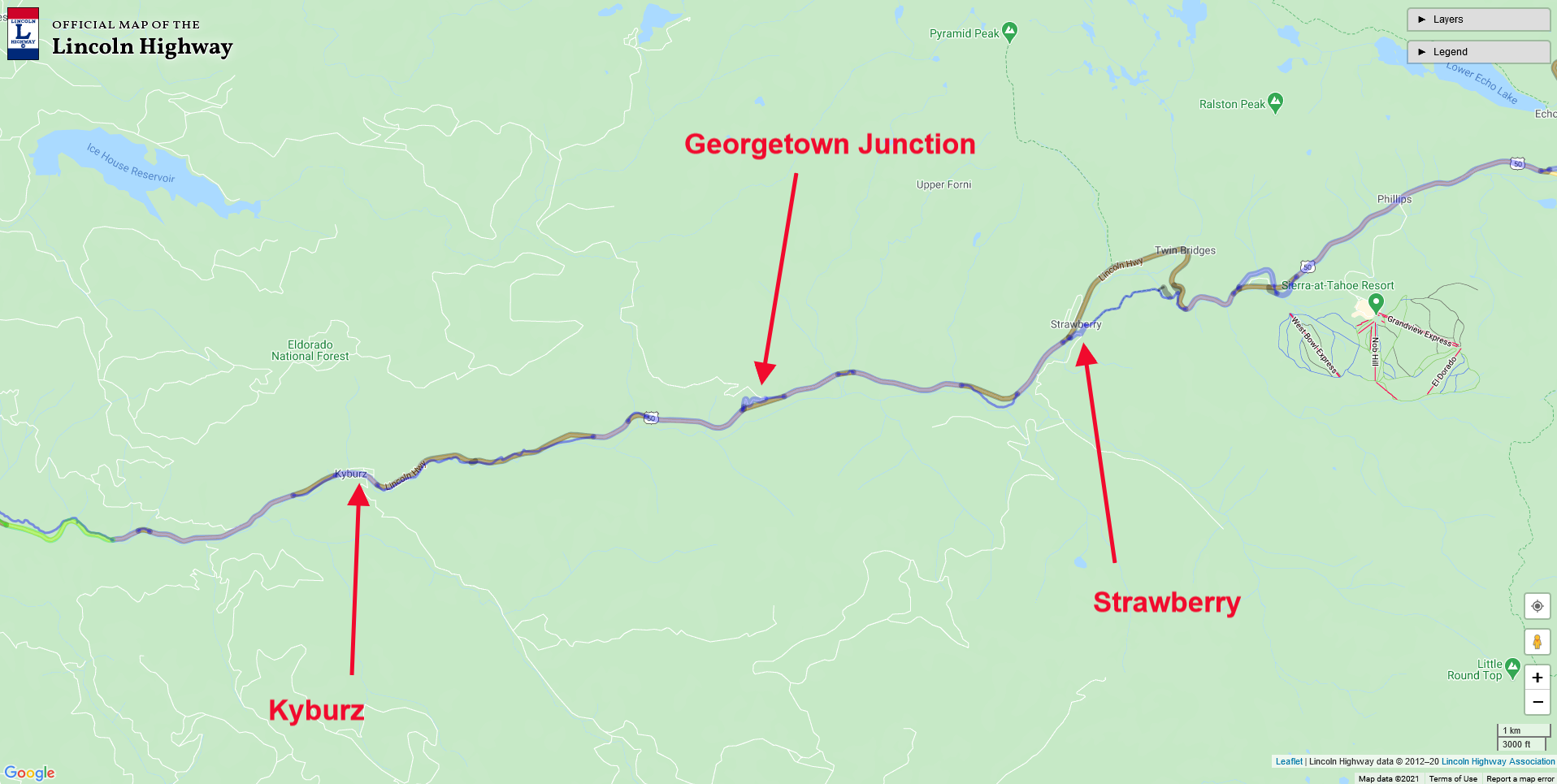
Map of the area between Kyburz and Strawberry, and The Georgetown Junction. Click map for larger view.

Map of the area between Kyburz and Strawberry, and The Georgetown Junction. Click map for larger view.

Leaving Strawberry, we head down the old Lincoln Highway, which Highway 50 closely follows today. However, there are many places along the freeway where the Lincoln Highway followed a more casual route. Milestone 41 is one such road, which today acts as an entrance to summer cabins. A number of these milestone roads were the Lincoln Highway, including Milestones 34 and 35. Another place the old road veers from today’s path is Wright’s Lake Road and the Georgetown Junction.

The Georgetown Junction once had a toll house, where a stone chimney left from those days stood well into the 20th Century. It seemed to be a popular place to take a photograph for Lincoln Highway and early Highway 50 for travelers. At its earliest, Georgetown Junction was where Johnson’s Trail left the river and climbed high up to Peavine Ridge, and eventually down to the river and a crossing at Bartlett’s Bridge. Later, after 1858 the state took over control of the road and built a new trail leaving the river further west at Silver Fork and the Sugar Loaf House site. Georgetown Junction then became a cut-off road for travelers headed to Georgetown rather than Placerville.

Monica on a found segment of the highway, off Wright’s Lake Road. Highway 50 is below, and to the right.

Monica on a found segment of the highway, off Wright’s Lake Road. Highway 50 is below, and to the right.

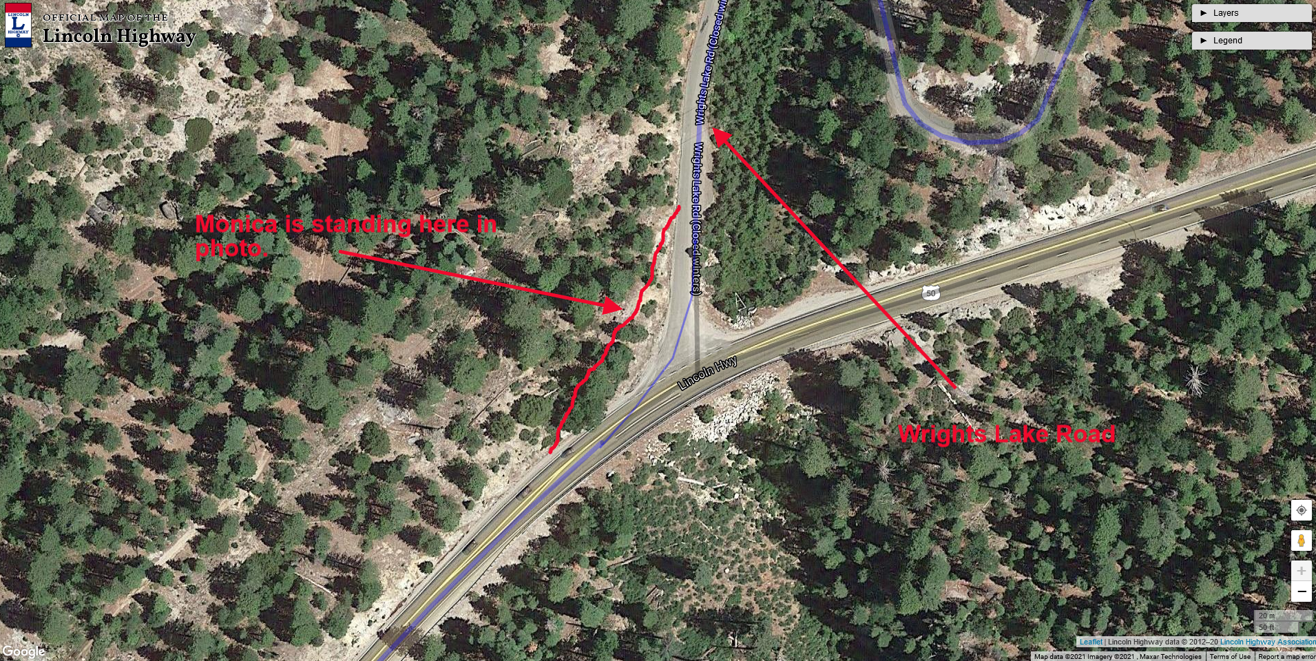
Map showing new segment in red. Wrights Lake Road is The Lincoln Highway. Click map for larger view.

Map showing new segment in red. Wrights Lake Road is The Lincoln Highway. Click map for larger view.

While we were exploring the area around Wright’s Lake Road, we discovered a small stretch of the old Lincoln Highway at the Wright’s Lake Road turnoff. On the map at left, you can see a red line indicating the section of the found road. You can see Monica standing on that portion of the road in the above photo, with Highway 50 down below and Wright’s Lake Road to the left.

Continuing downhill from Wright’s Lake Road, we come to a wide spot on the right that is the site of Fred’s Place, a top-rated stop for food and lodging from the Lincoln HIghway days well into the Highway 50 era. We have written about Fred’s Place before. You can read more about it here.

During the Highway 50 era, Fred's Place placed the fake, wooden CHP car to get people to slow down as the grade here was quite steep, and people tended to pick up speed.

During the Highway 50 era, Fred's Place placed the fake, wooden CHP car to get people to slow down as the grade here was quite steep, and people tended to pick up speed.

A bit further downhill from Fred's Place's site is Milestone Tract 34, which enters and exits on your left side. Drive this section of forest road to experience the Lincoln Highway in its original form. Half-way down Milestone 34, we come to the site of the "Register Rock,” or “Split Rock," which acted as a billboard back in the day. Some of the writing is still visible, such as an ad for pianos in Oakland.

Below is a short 2-minute video Monica and I made a few years back on Milestone 34.

Tags: Register Rock, Split Rock, Milestone 34, Lincoln Highway, El Dorado County, Wrights Lake Road, Johnson's Cut-Off Trail, Highway 50, historic highways, California history
Comment
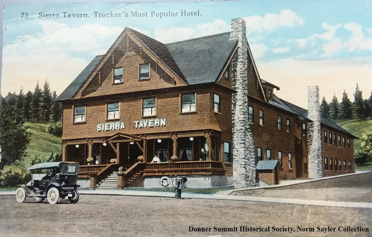
Sierra Tavern before the Lincoln Highway. The building burned down in 1927. Notice the old Bowser Fuel Pump in the center of the photo.

Sierra Tavern before the Lincoln Highway. The building burned down in 1927. Notice the old Bowser Fuel Pump in the center of the photo.

Truckee on the Lincoln Highway

January 02, 2021 in Nevada County History, Lincoln Highway, Sierra Nevada History
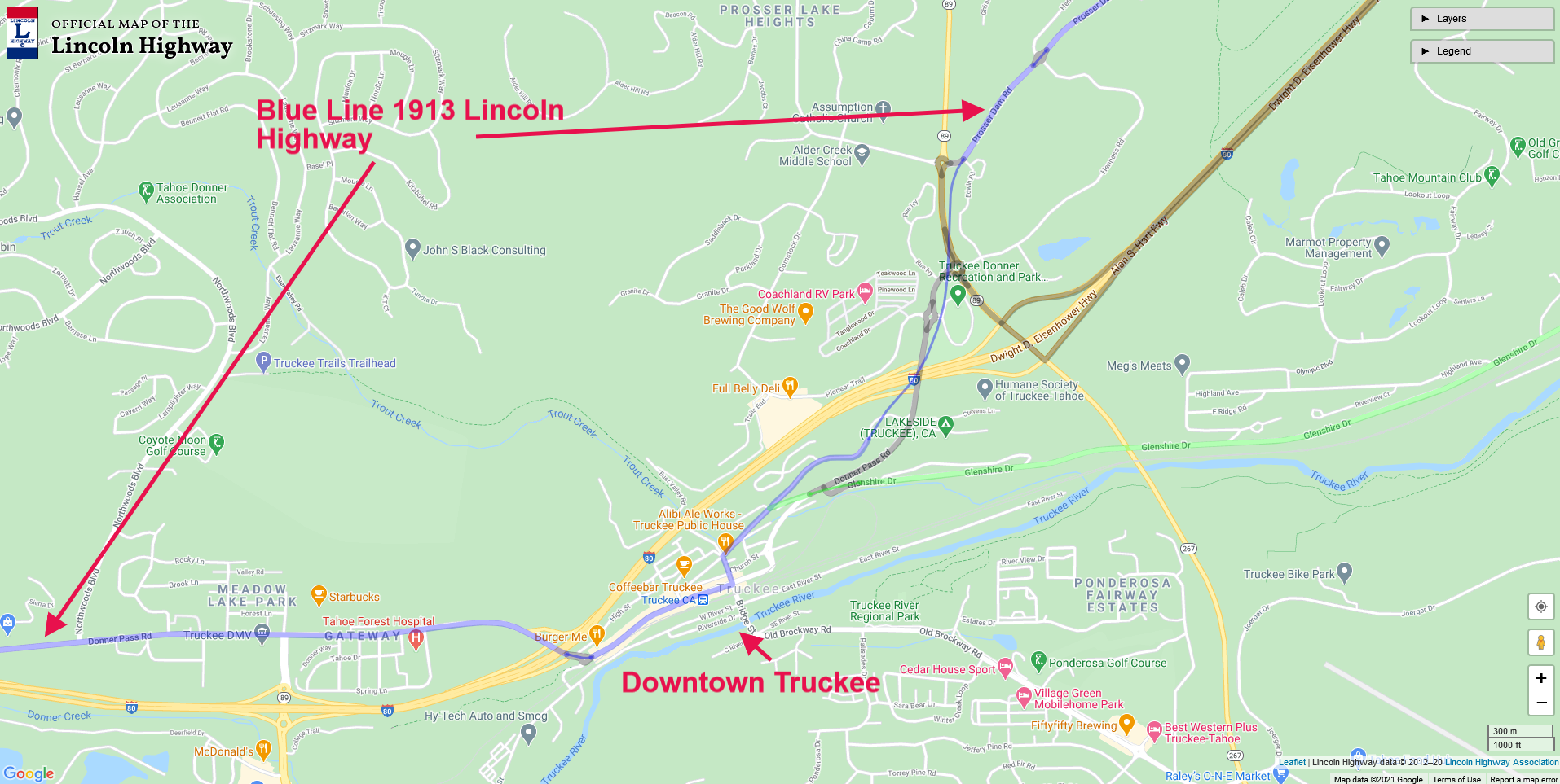
Map of Truckee showing the route of the Lincoln Highway. Click map for larger view.

Map of Truckee showing the route of the Lincoln Highway. Click map for larger view.

The early eastbound Lincoln Highway traveler would have entered Truckee via the present-day Prosser Dam Road, which today crosses Highway 89, which has obliterated any old road traces. You can pick up the road by heading down E. Jibboom Street, which runs into Bridge Street. E. Jibboom Street was before the Lincoln Highway, a county road, and before that, the Dutch Flat Donner Lake Wagon Road (DFDLWR), built by the Central Pacific Railroad.

In the photo below, taken around the 1920s, we are looking north at Truckee and the Lincoln Highway, which is quite visible heading up the mountains. The early Lincoln Highway in this area followed the DFDLWR.

1920s view of Truckee and the Lincoln Highway.

1920s view of Truckee and the Lincoln Highway.

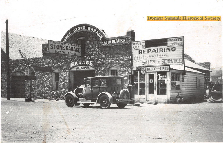
Heading down The Lincoln Highway on East Jibboom, we come to Bridge Street and the Stone Garage, a landmark today. There is a plaque outside installed by the California Lincoln Highway Association and E Clampus Vitus, which describes this place's history.

Truckee Stone Garage on Bridge and E Jibboom Streets.

Truckee Stone Garage on Bridge and E Jibboom Streets.

Once past the Truckee Stone Garage we turn right on Donner Pass Road and head down one block to Spring Street and the site of the Sierra Tavern, a popular stopping place along the old road. The first photo at the top of the blog shows the magnificent structure, which burned down in 1927, the year the Lincoln Highway became Highway 40.

Plaque on the wall of the Stone Garage.

Plaque on the wall of the Stone Garage.

Sierra Tavern in 1908 with Charles Fayette McGlashan’s home at the top left. Mc Glasahan was a prominent citizen of Truckee.

Sierra Tavern in 1908 with Charles Fayette McGlashan’s home at the top left. Mc Glasahan was a prominent citizen of Truckee.

In the photo above, we can see the Sierra Tavern in 1908, five years before the Lincoln Highway. A lone automobile sits on Spring Street. The building at the top left was the home of CF McGlashan, a prominent Truckee Citizen. That building is long gone and was replaced by a Quonset hut shaped building for Truckee Veterans. To the Sierra Tavern's right, across Spring Street, we can see the Chance Saloon and OK Bar where the photo below was taken.

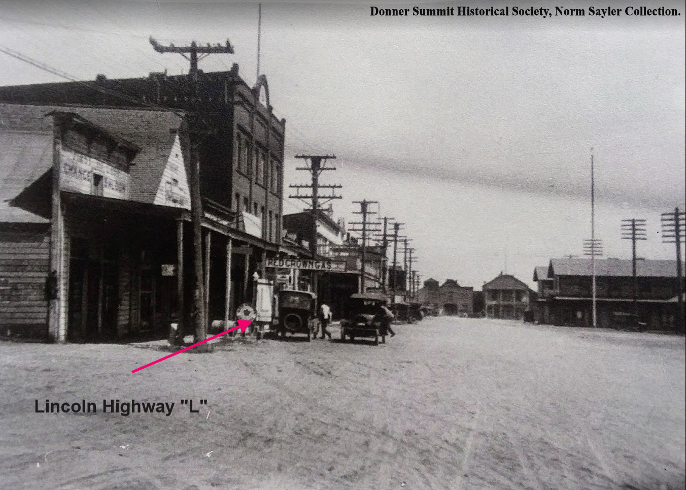
Rare photo of a Lincoln Highway “L” sign on Donner Pass Road, Truckee, sometime in the late 1910s, early 1920s.

Rare photo of a Lincoln Highway “L” sign on Donner Pass Road, Truckee, sometime in the late 1910s, early 1920s.

In our next installment of the Lincoln Highway’s northern route, we will continue our trip towards the summit but will first stop to check out the Donner Party’s encampment site, now known as Donner Memorial State Park.

Photographs from Donner Summit Historical Society, Norm Sayler Collection, and Adventures in California History.

Tags: Truckee Trail, Lincoln Highway, Sierra Nevada history, Sierra Nevada Summit, Nevada County, auto, fuel station, Donner Party, Donner Summit, Dutch Flat Wagon Road
Comment
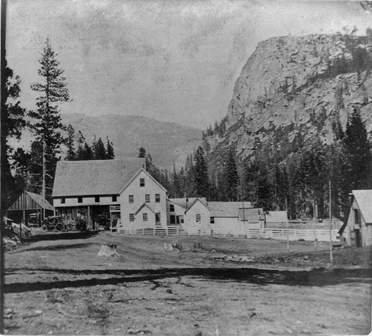
Strawberry in 1866. Lovers Leap is the large rock face at right. This place sat right where Highway 50 traverses today. We are looking east. Click photo for closer view.Library of Congress.Lawrence & Houseworth, Publisher. General View of Strawb…

Strawberry in 1866. Lovers Leap is the large rock face at right. This place sat right where Highway 50 traverses today. We are looking east. Click photo for closer view.
Library of Congress.Lawrence & Houseworth, Publisher. General View of Strawberry Valley, El Dorado County. , 1866. [Published] Photograph. https://www.loc.gov/item/2002721306/.

Strawberry on the Lincoln Highway's southern route, part 6.

December 04, 2020 in Lincoln Highway, El Dorado County History, Georgetown Divide History

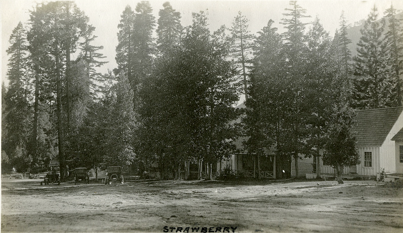
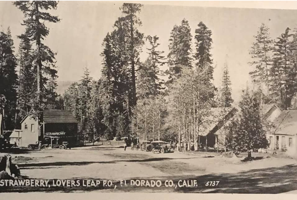
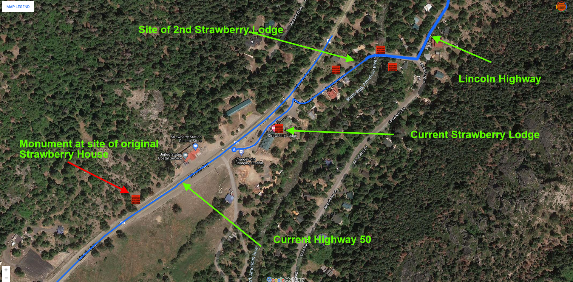
These wonderful photos show Strawberry’s two locations. The location of the Strawberry House has been a source of confusion for me. The secret is realizing there were a total of four Strawberry Houses over the years. Irad Barry built the first roadhouse in 1858 along what is now Highway 50. There is a state rock monument describing the first location just west of the gas station. It was here that a second larger lodge was built and stood until a fire destroyed it in 1867. The photo above shows the huge structure.

Strawberry cabins in 1920. We are facing east. Click photo for closer look.  “McCarthy Album 04, Photograph 068,” California State Archives Exhibits,

Strawberry cabins in 1920. We are facing east. Click photo for closer look. “McCarthy Album 04, Photograph 068,” California State Archives Exhibits,

After the disastrous fire of 1867, the new owner, Charlie Watson, re-built the station, but a bit up the road, just before the bridge crossing the American River. The photo above shows this new location. It was this location that would see the rise in automobile traffic after the turn of the century. This spot would be owned by the Watson and Martin Families from 1867 to 1938. While autos did pass down the old Swan-Henry Road, the Lincoln Highway in 1913 breathed new life into the old rest stop. For the next 16 years, the place was a beehive of activity as American's took to the road in their new Model T's.

Strawberry Resort on the Lincoln Highway,

Strawberry Resort on the Lincoln Highway, The photo above is courtesy of Laura Bantz

In 1929 the Great Depression was upon us, and the acquisition of automobiles and traveling slowed down as well. Who had the money to do it? The second reason business slowed was the highway's re-routing in 1931 from the old Swan-Henry Toll Road/Lincoln Highway to today's route. This bypassed the old resort and, combined with the Depression, helped in its eventual demise in 1939, just before World War II.

In 1939 Fred Baumhoff built the structure we know today as Strawberry Lodge along the new Highway 50. This would make the third location of the famous Strawberry House/Lodge/Resort. Fred’s Resort didn’t have much time to become a success as World War II roared into the 1940s, and men and equipment were in short supply. In 1943 Fred sold the business, and it had some success in the 1950s and 1960s, but people and their driving habits changed, and no one wanted to stop and take in the fresh air and views anymore.

Today the resort sits somewhat forlorn, waiting for its next big break or its next big disaster. Until people slow down and stop to smell the flowers once again, it will likely be a place that most just speed by on their way to somewhere else.

Our next stop along the southern route of the Lincoln Highway will be the Georgetown Junction, a wide spot along the road today, but back in the 1800s a major crossroads.

Map showing the sites of the three Strawberry buildings. Click map for a larger view.

Map showing the sites of the three Strawberry buildings. Click map for a larger view.

Tags: Strawberry, El Dorado County, emigrant trails, lodge, Swan-Henry Toll Road, Lincoln Highway, Highway 50, historic bridges, transportation history, Truckee Trail, Lovers Leap, Kyburz
1 Comment
Prev / Next

Use the box below to find specific subjects.

No results found

Archive

  • September 2026
    • Sep 8, 2026 Maiden's Grave to Tragedy Spring on the 1848 California Trail Sep 8, 2026
    • Sep 3, 2026 The 1852 Johnson Cutoff Trail at Lake Tahoe by Cave Rock Sep 3, 2026
  • August 2026
    • Aug 26, 2026 Hope Valley, Alpine County: Pioneer Trail at Carson Creek Aug 26, 2026
  • July 2023
    • Jul 23, 2023 Emigrant Trail at Caples Lake, Alpine County Jul 23, 2023
  • August 2022
    • Aug 12, 2022 1922 Moreland Truck at Johnson's Pass Aug 12, 2022
  • November 2021
    • Nov 2, 2021 Lincoln Highway artifact found! Nov 2, 2021
  • June 2021
    • Jun 23, 2021 Following the Lincoln Highway at Zephyr Cove, Nevada Jun 23, 2021
  • March 2021
    • Mar 26, 2021 Folsom, a Lincoln Highway Community Mar 26, 2021
  • February 2021
    • Feb 17, 2021 Bowman crossing and a newly found alignment of the Lincoln Highway. Feb 17, 2021
  • January 2021
    • Jan 31, 2021 Iowa Hill William "Seattle Bill" James, baseball legend Jan 31, 2021
    • Jan 30, 2021 Horse team carrying sand for the construction of the Mountain Quarries Railroad Jan 30, 2021
    • Jan 28, 2021 Rattlesnake Bar Road and Bridge site Jan 28, 2021
    • Jan 16, 2021 The Quonset Hut Motel near Colfax Jan 16, 2021
    • Jan 14, 2021 Brockliss Bridge site Jan 14, 2021
    • Jan 11, 2021 Alta and the Lincoln Highway Jan 11, 2021
    • Jan 10, 2021 A busy day at Baxter along old Highway 40 Jan 10, 2021
    • Jan 9, 2021 A summertime day in Auburn, 1916. Jan 9, 2021
    • Jan 8, 2021 Georgetown Junction, historic crossroads along the Lincoln Highway Jan 8, 2021
    • Jan 2, 2021 Truckee on the Lincoln Highway Jan 2, 2021
  • December 2020
    • Dec 4, 2020 Strawberry on the Lincoln Highway's southern route, part 6. Dec 4, 2020
    • Dec 3, 2020 A crossroads on the northern route of the Lincoln Highway, Part 5 Dec 3, 2020
  • November 2020
    • Nov 28, 2020 Colfax, Placer County, 1870s Nov 28, 2020
    • Nov 26, 2020 Slippery Ford to Strawberry on the Lincoln Highway, part 5 Nov 26, 2020
    • Nov 22, 2020 Dog Valley to Truckee on the northern route of the Lincoln Highway, Part 4 Nov 22, 2020
    • Nov 20, 2020 The children of Long Valley School, Placer County, 1890 Nov 20, 2020
    • Nov 19, 2020 The Falls of Salmon Falls. Nov 19, 2020
    • Nov 18, 2020 Slippery Ford on the Lincoln Highways southern route, Part 4 Nov 18, 2020
    • Nov 14, 2020 Verdi to Henness Pass Road on the old Lincoln Highway northern route, part 3 Nov 14, 2020
    • Nov 11, 2020 Echo Summit to Slippery Ford on the Lincoln Highway southern route, Part 3 Nov 11, 2020
    • Nov 8, 2020 Greenwood, El Dorado County school and playground, 1953 Nov 8, 2020
    • Nov 7, 2020 Verdi, Nevada to the California line on the northern route of the Lincoln Highway, Part 2 Nov 7, 2020
    • Nov 5, 2020 The Lodge at Echo Summit, Lincoln Highway, Part 6 Nov 5, 2020
  • October 2020
    • Oct 31, 2020 1895 Citrus Colony Cricket Team, Rocklin, California Oct 31, 2020
    • Oct 30, 2020 The Lincoln Highway, EL Dorado County, Johnson's Pass, Part 5 Oct 30, 2020
    • Oct 29, 2020 The Lincoln Highway, Verdi, Nevada Oct 29, 2020
    • Oct 24, 2020 Meyers Grade to Johnson's Pass, Lincoln Highway in El Dorado County, Part 4 Oct 24, 2020
    • Oct 23, 2020 Aerial view Auburn at the turn of the century Oct 23, 2020
    • Oct 22, 2020 The Lincoln Highway at Meyer's, El Dorado County Part 3 Oct 22, 2020
    • Oct 21, 2020 The Lincoln Highway in El Dorado County, Part 2, historic Trout Creek Bridge Oct 21, 2020
    • Oct 18, 2020 Exploring the Lincoln Highway in El Dorado County, Part 1 Oct 18, 2020
    • Oct 16, 2020 The Yuba River at Big Bend Oct 16, 2020
    • Oct 14, 2020 Big Bend, crossroads in history. Oct 14, 2020
    • Oct 10, 2020 Robert Fowler and his airplane Oct 10, 2020
    • Oct 8, 2020 A 1923 alignment of the Lincoln Highway found Oct 8, 2020
    • Oct 1, 2020 Lincoln Highway alignment found near Fresh Pond Oct 1, 2020
  • September 2020
    • Sep 30, 2020 The Lincoln Highway from Fry Creek to Milestone 29 Sep 30, 2020
    • Sep 22, 2020 The Summit Station and Hotel, Donner Summit Sep 22, 2020
    • Sep 19, 2020 Once upon a time at "Lookout Point", Emigrant Gap. Sep 19, 2020
    • Sep 12, 2020 The Yuba River, a historic transportation corridor Sep 12, 2020
    • Sep 11, 2020 Dutch Flat Wagon Road at Castle Creek, Soda Springs. Sep 11, 2020
    • Sep 6, 2020 Big Bend in Transportation History Sep 6, 2020
    • Sep 5, 2020 Yesterday and today on the Lincoln Highway, Big Bend. Sep 5, 2020
    • Sep 4, 2020 Lincoln Highway bridge at Rainbow in the Sierra Nevada Sep 4, 2020
    • Sep 3, 2020 Highway 40 crossing at Emigrant Gap Sep 3, 2020
  • August 2020
    • Aug 6, 2020 Lost Lincoln Highway alignments Aug 6, 2020
    • Aug 1, 2020 TC Wohlbrück and his Canteen Service Stations Aug 1, 2020
  • March 2020
    • Mar 27, 2020 Georgetown Divide History Tour, Part 4 Mar 27, 2020
    • Mar 21, 2020 Green Valley Road Historical Tour, Part 3 Mar 21, 2020
    • Mar 19, 2020 Leland Stanford and his store Mar 19, 2020
    • Mar 18, 2020 Georgetown Divide History Tour, Part 3 Mar 18, 2020
    • Mar 14, 2020 Green Valley Road History Tour, Part 2 Mar 14, 2020
    • Mar 12, 2020 Georgetown Divide History Tour, Part 2 Mar 12, 2020
    • Mar 7, 2020 The Green Valley Road History Tour! Mar 7, 2020
    • Mar 6, 2020 Finding Historic "C" Markers Mar 6, 2020
    • Mar 5, 2020 The old Lotus Bridge site, and the Georgetown Divide history tour Mar 5, 2020
    • Mar 4, 2020 A quiet road in Roseville Mar 4, 2020
  • February 2020
    • Feb 28, 2020 Wimpy's Fireplace Feb 28, 2020
    • Feb 8, 2020 Sam Kyburz house, Clarksville Feb 8, 2020
    • Feb 7, 2020 Tobacco growing in Placer County Feb 7, 2020
    • Feb 5, 2020 The Rolling Hills Hotel Feb 5, 2020
  • January 2020
    • Jan 30, 2020 New York Ravine, Salmon Falls Jan 30, 2020
    • Jan 23, 2020 Georgetown fire of 1869 Jan 23, 2020
    • Jan 22, 2020 The W A Thomas Store, Roseville Jan 22, 2020
    • Jan 19, 2020 The old swimming hole at Rattlesnake Bar Jan 19, 2020
    • Jan 18, 2020 The Hogsback Mine near Foresthill Jan 18, 2020
    • Jan 17, 2020 Kentucky House, on the old Coloma-Folsom Road Jan 17, 2020
    • Jan 16, 2020 Otwell Grocery Store along the Lincoln Highway. Jan 16, 2020
    • Jan 10, 2020 Auburn Ski Club Brochure, 1934 Jan 10, 2020
    • Jan 9, 2020 Pelton Water Wheel, Mammoth Bar Mine, 1895 Jan 9, 2020
    • Jan 8, 2020 Central Square, Auburn, California Jan 8, 2020
    • Jan 4, 2020 Highway 40 bridge construction, Colfax, 1938 Jan 4, 2020
    • Jan 2, 2020 "Shafthouse of the Sherman Mine perched high up on the hillside overlooking the town". Jan 2, 2020
    • Jan 1, 2020 The Third Strawberry House Jan 1, 2020
  • December 2019
    • Dec 28, 2019 Looking north on Lincoln Way Dec 28, 2019
    • Dec 20, 2019 Auburn Ski Club at Cisco Grove. Dec 20, 2019
    • Dec 19, 2019 Quiet day on Highway 40, Auburn Dec 19, 2019
    • Dec 18, 2019 Damascus, a ghost town in Placer County Dec 18, 2019
    • Dec 17, 2019 Iowa Hill baseball team and a surprise. Dec 17, 2019
    • Dec 13, 2019 Iowa Hill Baseball Team Dec 13, 2019
    • Dec 12, 2019 Placer Garage, Lincoln Highway, Auburn Dec 12, 2019
    • Dec 10, 2019 Deadwood, Placer County Dec 10, 2019
    • Dec 9, 2019 Auburn old town, no more Dec 9, 2019
    • Dec 8, 2019 Highway 40 Construction Dec 8, 2019
  • November 2019
    • Nov 29, 2019 Strawberry House, there were two locations. Nov 29, 2019
    • Nov 23, 2019 Johnson's Pass on the Lincoln Highway Nov 23, 2019
    • Nov 21, 2019 Auburn railroad crossing gets a new addition Nov 21, 2019
  • October 2019
    • Oct 31, 2019 Lincoln Highway 106 years old today! Oct 31, 2019
    • Oct 19, 2019 The Pioneer! Oct 19, 2019
    • Oct 14, 2019 Then and now, along the old Lincoln Highway in Penryn Oct 14, 2019
  • September 2019
    • Sep 30, 2019 Sierra Summit-Truckee Highway Sep 30, 2019
    • Sep 29, 2019 Summit of the Sierra Sep 29, 2019
    • Sep 26, 2019 Trout Creek bridge date Sep 26, 2019
    • Sep 25, 2019 Found! 1923 alignment of the Lincoln Highway. Sep 25, 2019
    • Sep 19, 2019 Highway 50 at Twin Bridges Sep 19, 2019
    • Sep 15, 2019 Whitehall on the Lincoln Highway Sep 15, 2019
    • Sep 14, 2019 Placerville to sign its section of the Lincoln Highway! Sep 14, 2019
    • Sep 4, 2019 1919 Army Convoy film, Part II Sep 4, 2019
    • Sep 1, 2019 The Convoy is Coming! Sep 1, 2019
  • August 2019
    • Aug 25, 2019 Truck entering new snowshed subway at Donner Summit Aug 25, 2019
    • Aug 23, 2019 Lincoln Highway by Donner Lake Aug 23, 2019
    • Aug 22, 2019 Donner Lake Camp Aug 22, 2019
    • Aug 21, 2019 Lets stay in a Quonset hut tonight! Aug 21, 2019
    • Aug 19, 2019 Dedication of corner stone for Donner Memorial Aug 19, 2019
    • Aug 17, 2019 Donner Monument, unfinished Aug 17, 2019
    • Aug 15, 2019 Army Convoy, 1919 Aug 15, 2019
    • Aug 13, 2019 Dedication of The Pioneer Monument Aug 13, 2019
    • Aug 9, 2019 Historic highway pole markers Aug 9, 2019
    • Aug 8, 2019 Victory Highway at Boca Aug 8, 2019
    • Aug 7, 2019 Gold Run on Highway 40 Aug 7, 2019
    • Aug 7, 2019 Where was this highway photo taken? Aug 7, 2019
    • Aug 4, 2019 The Lincoln Highway at Donner Summit Aug 4, 2019
    • Aug 2, 2019 Norm Sayler, History Talks Aug 2, 2019
    • Aug 1, 2019 The vanishing Lake Van Norden and the Lincoln Highway Aug 1, 2019
  • July 2019
    • Jul 31, 2019 Norm Sayler and the Donner Summit Historical Society Jul 31, 2019
    • Jul 31, 2019 Truckee 1919 and The Lincoln Highway "L" Jul 31, 2019
    • Jul 29, 2019 Auburn Ravine Jul 29, 2019
    • Jul 27, 2019 Fred's Place, Highway 50, El Dorado County Jul 27, 2019
    • Jul 26, 2019 Pacific House in the 1920's Jul 26, 2019
    • Jul 24, 2019 Lincoln Highway, Emigrant Gap Jul 24, 2019
    • Jul 21, 2019 Weimar subway Lincoln Highway logo Jul 21, 2019
    • Jul 11, 2019 Walk with history Jul 11, 2019
    • Jul 10, 2019 Weimar Crossroads railroad subway painted Jul 10, 2019
    • Jul 7, 2019 Eisenhower and Army convoy leave Washington DC headed to San Francisco Jul 7, 2019
    • Jul 1, 2019 Painting Lincoln Highway Logo, Newcastle 1910 bridge. Jul 1, 2019
  • June 2019
    • Jun 29, 2019 Interstate Highway system signed in law on this date, 1956 Jun 29, 2019
    • Jun 20, 2019 Bachelor Buttons for emergency repairs Jun 20, 2019
    • Jun 15, 2019 Who invented the "rearview mirror"? Jun 15, 2019
    • Jun 14, 2019 Lincoln Highway Travelers Guide Jun 14, 2019
    • Jun 13, 2019 Gold Discovery Centennial Celebration in Coloma, California Jun 13, 2019
    • Jun 7, 2019 Odd Fellows Lodge, Georgetown Jun 7, 2019
    • Jun 2, 2019 Adventures in California History, Lincoln Highway style Jun 2, 2019
  • February 2019
    • Feb 21, 2019 Ranger Survey Ship, and sailors 1890 Feb 21, 2019
    • Feb 20, 2019 Fingal, Riverside County, Sunset Limited train 1898 Feb 20, 2019
    • Feb 10, 2019 Day at the beach in San Francisco, 1903 Feb 10, 2019
  • December 2018
    • Dec 13, 2018 Spenceville, a copper mining town Dec 13, 2018
    • Dec 12, 2018 Finding stuff on the way to Timbuctoo Dec 12, 2018
    • Dec 7, 2018 We're on our way to Timbuctoo! Dec 7, 2018
    • Dec 1, 2018 Headed back to Wheatland Dec 1, 2018
  • November 2018
    • Nov 30, 2018 Rattlesnake Bar Bridge site Nov 30, 2018
    • Nov 27, 2018 At the end of the trail Nov 27, 2018
    • Nov 26, 2018 A Lincoln Highway artifact discovered! Nov 26, 2018
    • Nov 23, 2018 A lost section of Highway 40 at Eagle Lakes Road. Nov 23, 2018
    • Nov 17, 2018 Searching for the Emigrant Trail at Alder Creek Nov 17, 2018
    • Nov 14, 2018 Searching for the Emigrant Trail, Mt. Olive Road, Nevada County Nov 14, 2018
    • Nov 9, 2018 Donner Camp Historic Park Nov 9, 2018
    • Nov 1, 2018 Taking the trip from Auburn to Truckee Nov 1, 2018
  • October 2018
    • Oct 24, 2018 Verdi, travelling through history Oct 24, 2018
    • Oct 21, 2018 Our first "adventure" map! Oct 21, 2018
    • Oct 13, 2018 Trademarks of early California Oct 13, 2018