Georgetown Divide History

The Lincoln Highway from Fry Creek to Milestone 29

Tuesday found Monica and I venturing into the Eldorado National Forest, searching the Lincoln Highway's old southern route between Fry Creek and Milestone 29. This is a fantastic section of old roadbed that has, for years, been buried under an accumulation of forest debris and erosion. We hiked this portion before, but the road/trail was blocked by manzanita and other plants, making it nearly impossible to travel farther.

Great news, as the forest has been cleared for fire prevention. All the growth that had hindered our progress has been removed, making for an easy hike. Most exciting is many hundreds of yards of rock retaining wall has now been exposed after over 100 years. Let's take a walk and we’ll show you what we have found.

screenshot-photos.google.com-2020.09.30-04_24_44.png
Iron piece on the west side of Fry Creek.

Iron piece on the west side of Fry Creek.

In the photo above, I’m looking at one of the first objects we found, a California “C” Monument, which was used to designate the state’s road boundaries. What is fascinating is there is no “C” printed on the block. There is only one other time we have found these markers with no letter “C” embedded in it. The marker indicates that our official map may be changed to show this previously unknown loop of the old road.

A hundred yards or so from the “C” Monument, the old road crossed Fry Creek. The only evidence of a bridge is iron sticking out of the granite on the west side, and a retaining wall on the east side.

screenshot-photos.google.com-2020.09.30-04_57_03.png

The photo above shows the small retaining wall, on the opposite side from the iron piece, hidden behind some bushes. The photo below shows the site looking west accross Fry Creek. There must have been a bridge here.

screenshot-photos.google.com-2020.09.30-05_05_29.png

The photo below shows the road just a few hundred yards east of Fry Creek, where we came upon this beautiful stone retaining wall. We don't know the year these walls we built. The Lincoln Highway was designated in 1913, but this road is older than that. This was California’s first wagon road, designated in 1895, predating the automobile, so the walls could have been built during the 19th Century.

screenshot-photos.google.com-2020.09.30-05_12_34.png

The photo below shows some of the clearings that have exposed this long retaining wall. We were quite impressed with the length and height of some of these walls. Truly expert craftsmanship to have withstood over 100 years of neglect.

screenshot-photos.google.com-2020.09.30-05_21_04.png

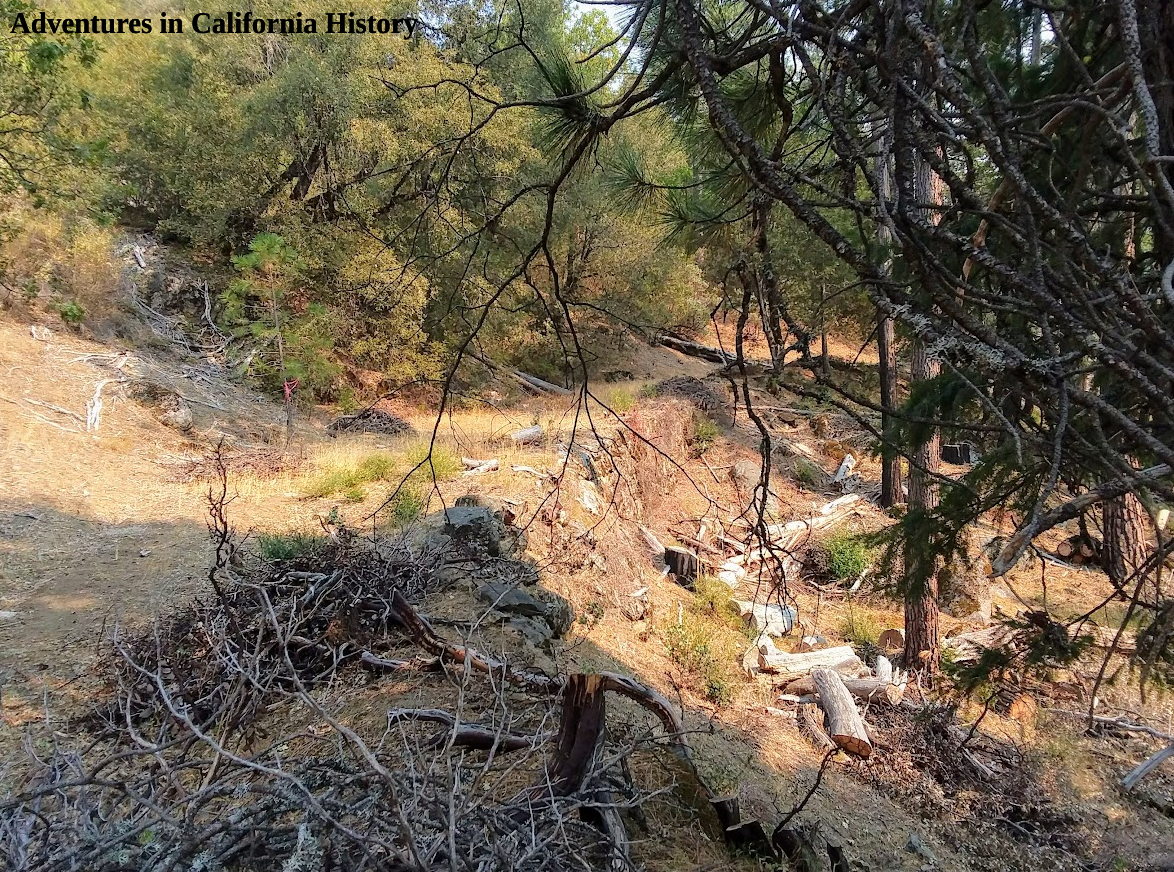
Below we see one of the longer walls and the piles of manzanita that have been cleared. This wall was completely hidden from view before this recent clearing. Below is one of the longer retaining walls we came upon. Notice the piles of manzanita bushes that have been cut out, exposing this once hidden wall.

screenshot-photos.google.com-2020.09.30-05_26_18.png

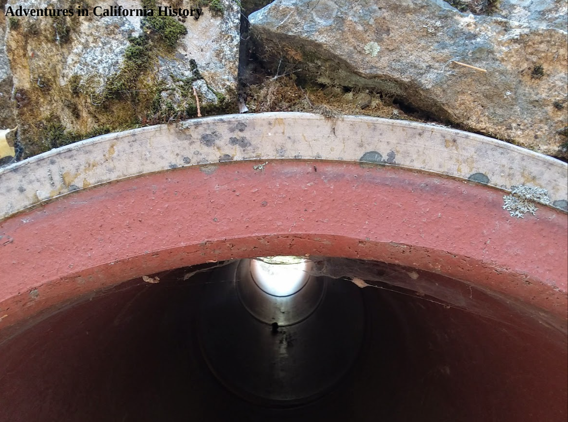
A little further on, we came upon a stream crossing and a terra cotta pipe passing under the roadbed. We have seen rock and metal culverts before, but never terra cotta or clay. Quite unusual.

screenshot-photos.google.com-2020.09.30-05_30_05.png

Monica is holding a portion of the clay pipe we found laying around. It’s quite thick and heavy.

screenshot-photos.google.com-2020.09.30-05_34_59.png

Still, further on, we came upon a stream crossing and another terra cotta pipe passing under the roadbed. In the photo below, we have walked a bit further east and found another pipe. Check out the size of that Terra Cotta pipe emerging from under the roadbed. It was in such good condition we wondered if it was a recent replacement. Nothing else has been repaired along this stretch of Lincoln Highway, so we assume this is an original culvert. Why clay was used in this particular situation, we do not know.

screenshot-photos.google.com-2020.09.30-05_37_58.png

Below is a photo closeup of the pipes double-layered construction. The outer white layer is quite hard. Not sure what type of material it’s made from.

screenshot-photos.google.com-2020.09.30-05_43_40.png

We are just about through with our hike and we can see Monica walking east on the old road towards our destination, Milestone 29 off Highway 50.

With the recent clearing having been done this stretch of the historic road is easily hiked. The retaining walls are extensive and easily spotted now with the clearing. Lot’s of bear scat around so it’s best to walk this during the daylight before dusk, lest one come upon a furrier traveler on the old road.

Monica heading east near Milestone 29.

Monica heading east near Milestone 29.

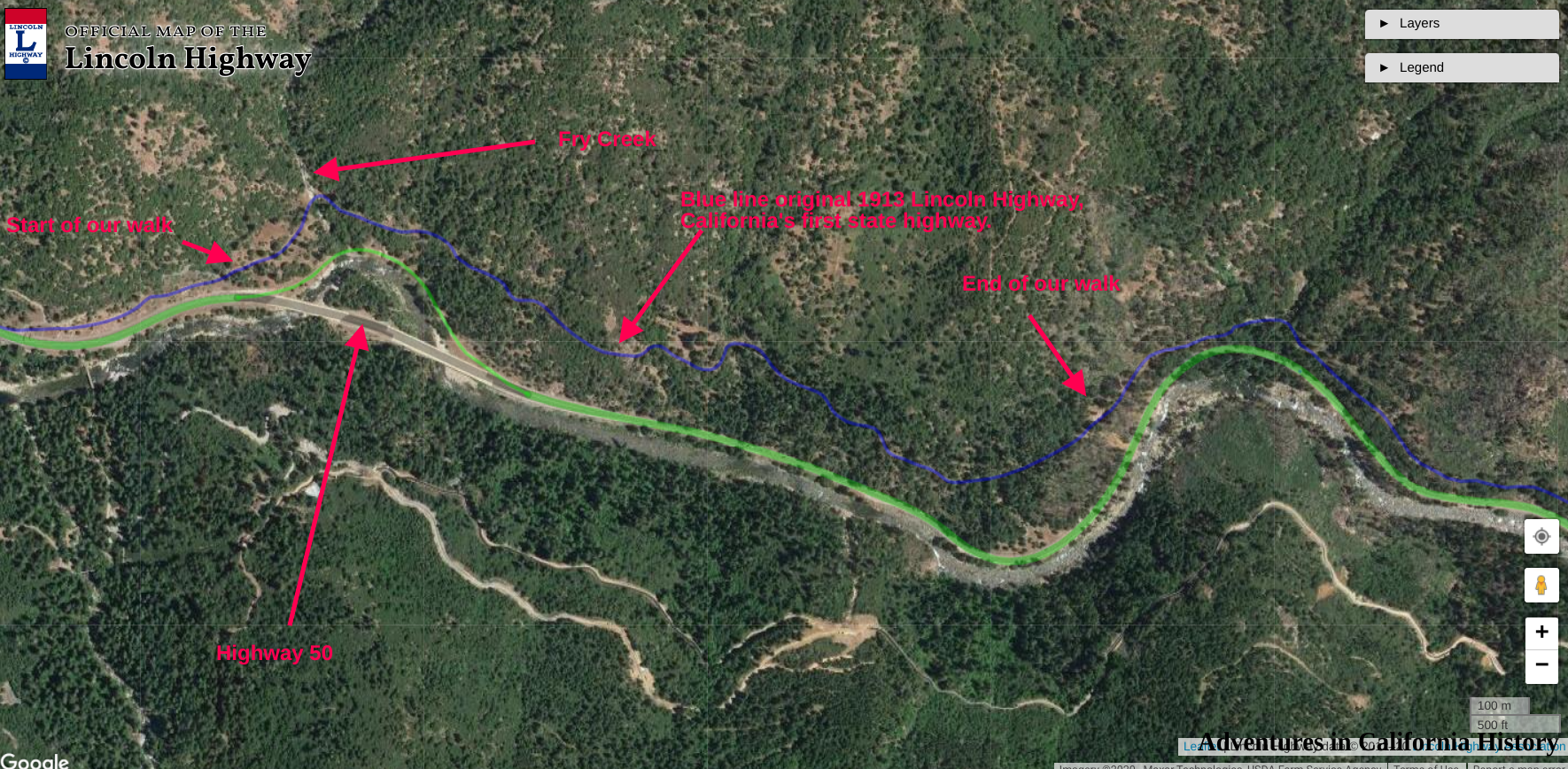
Below is a map showing the location of our adventure. We started near Fry Creek at the left and followed the blue line towards Milestone 29 on the right. Very little of this section of the old road is visible from Highway 50.

Click map to see a larger version.

Click map to see a larger version.

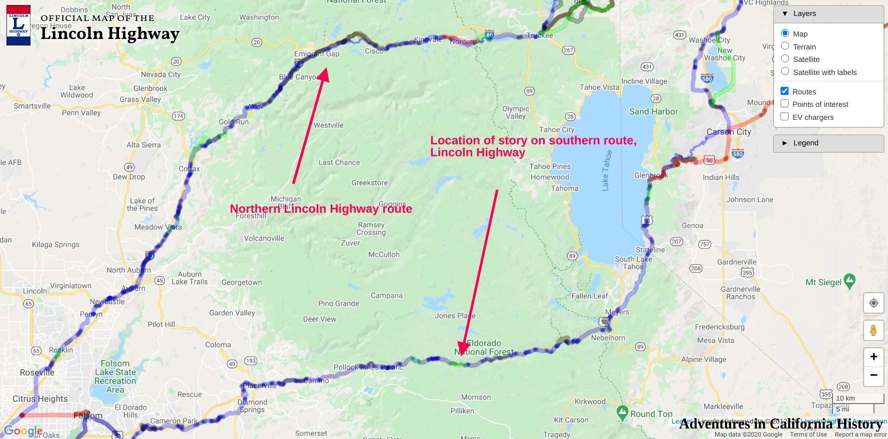
Below is a map showing the two routes of the Lincoln Highway through the mountains of California. Our adventure this time is on the southern route in El Dorado County.

Click map to see a larger version.

Click map to see a larger version.

Georgetown Divide History Tour, Part 3

We continue our tour of the historical side of The Georgetown Divide. During our last stop, we viewed the old Meyer's Dance Hall and Saloon, located in Uniontown, now known as Lotus. You can find that post here. Leaving Beach Street and turning left onto Highway 49, let's head to the site of Michigan Flat, located in today's Bacchi land, home of a local ranching family.

The Georgetown Divide History tour

The above map is interactive. You can zoom in and out to get a closer view. Click the orange boxes for more info on a particular site. To enlarge the map click the square at top right.

Michigan Flat is famous for being the site of one of the Stanford Brothers stores. Leland and Thomas kept a couple of stores in the gold country, with Thomas manning the one in Michigan Flat. One of the stones that made up the building still exists, supposedly in front of one of the homes in this area. For many years it was a feat to try and lift this stone. I wonder if it still exists?

Amos Bowman’s 1873 map of the Georgetown Divide. Interactive version here.

Amos Bowman’s 1873 map of the Georgetown Divide. Interactive version here.

In the above 1873 map, we can see Michigan Flat as well as what appears to be an old river crossing near Greenwood Creek. These river fords were common, as the dams upriver hadn't been built, so in summer and fall, the water levels would drop so one could ford these rivers. Another interesting spot on the map is a town called Powningville, of which I can find no information, altho it's quite prominent on the map.

Michigan Flat consisted of several smaller mining camps with names like Red Hill, Coyote Diggins, and Rich Gulch. Before the Stanford Brothers built their store, Charles Smith had the first store in Michigan Flat, in a tent located at the location where Greenwood Creek empties into the south fork of the American River. We have marked his store site on the map. A man named Tutsbury built a butcher shop, hotel, and boarding house where drink cost fifty cents! Wentzel Stock had the first bakery. On the flat itself, Charles Dusenberg was the first merchant in 1850 with his canvas shop. The Stanford brothers then built their shop, while John Hass kept the watch at his store. Jack Miller kept three more boarding houses and a bakery, while Dr's. Stone and Wheelock were the town's physicians.

1868 Township and county Map. Interactive version here.

1868 Township and county Map. Interactive version here.

In the above earlier map, from 1863, we see no mention of Powningville, but we do know the site of the old Magnolia Hotel in both charts. This old building was still standing in 1915. We have marked the possible location on our tour map. Also, I have included a shot of the potential site from Google Earth. Is this the old Magnolia Hotel site? Also of interest in the 1868 map is the site of the home of J.W. Marshall, Discoverer of Gold. This possible Magnolia House site is on private property, and please respect.

Ever wonder why the Bureau of Land Management trail-head nearby is called, Magnolia Ranch? Now you and I know. The old Magnolia House.

Is this the Magnolia House site?

Is this the Magnolia House site?

Powningville is quite a mystery. We have marked where we think the town stood on our map. You can compare it with the 1873 Amos Brown Map above. There is little to no reference to this town, other than the map. The other aspect of Powningville that I find interesting is the road titled, “Coloma Trail” that takes off from that town, roughly parallelling Highway 49 towards Cool. Powningville was close to the Fairmont Copper Mines, which according to the 1866 report by D.V. Whiting, Esq, also contained large blocks of the mineral garnet.

The old Coloma Trail, long gone.

The old Coloma Trail, long gone.

To continue our historical tour of The Georgetown Divide we continue north on Highway 49 towards the old town of Pilot Hill. We will cover that section in our next tour post. The map of the tour can be found in our maps section, here.