

While heading east following the Lincoln Highway route past Fresh Pond, we turned left on Outer Limits Road, then a quick right on to Dubasary Lane headed towards the Ranger Station. As is often the case in California's mountains, the Lincoln Highway's old 1913 route diverges from today’s Highway 50 freeway winding its way around the contours of the hills. In the early part of the 20th Century, equipment like a steam shovel was unavailable, so the roads couldn’t be cut into the hills like they were in subsequent years. Often the Lincoln Highway would follow older wagon roads and emigrant routes. Here is no exception as this route follows the old Johnson Cut-Off Trail from the mid-1800s.
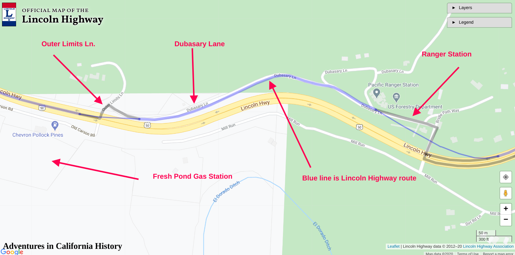
Map showing location. Click map for larger view.
Just down Dubasary Ln., we came upon a section of the old road complete with a white centerline, which you can see in the photo at the top of the page. We tried to follow it, but Highway 50 is just to the right, and during its construction in the 1950s, the old road was covered with rock, making access impossible.
Traveling a bit further down Dubassary Lane, we spotted a “C” monument, also known as a “right-of-way” monument. These concrete structures were used by the highway department to signify the state-owned roadway. Typically they were placed about 15 feet from the edge of the state highway, with an imprinted letter “C” facing the road. The “C” stands for California. Nevada has its own monuments with the letter “N.” This marker had no “C” visible, so we jumped out of the car and investigated.

Trey pointing to the “C” monument with no visible “C”.
While the monument had no visible “C” from Dubasary Lane, there was a “C” imprinted on the opposite side, which indicates the old road was on the other side of the chain-link fence. Now the old route started to make sense. The old Lincoln Highway was closer to the newer Highway 50 than previously thought.

The hidden “C”.
It was hard to get this photo as the chain-link fence made it impossible to walk around. The “C” is clearly visible and indicating the roadbed edge was 15 feet on the other side of the fence. In the following photograph, our car is parked, facing west at the site of the monument. We can see how far the old road is from Dubasary Ln., about 15 feet past the fence at left.

Below is the official Lincoln Highway map showing a satellite view of the area. I have shown some of the features and drawn in red the found route of the old Lincoln Highway.
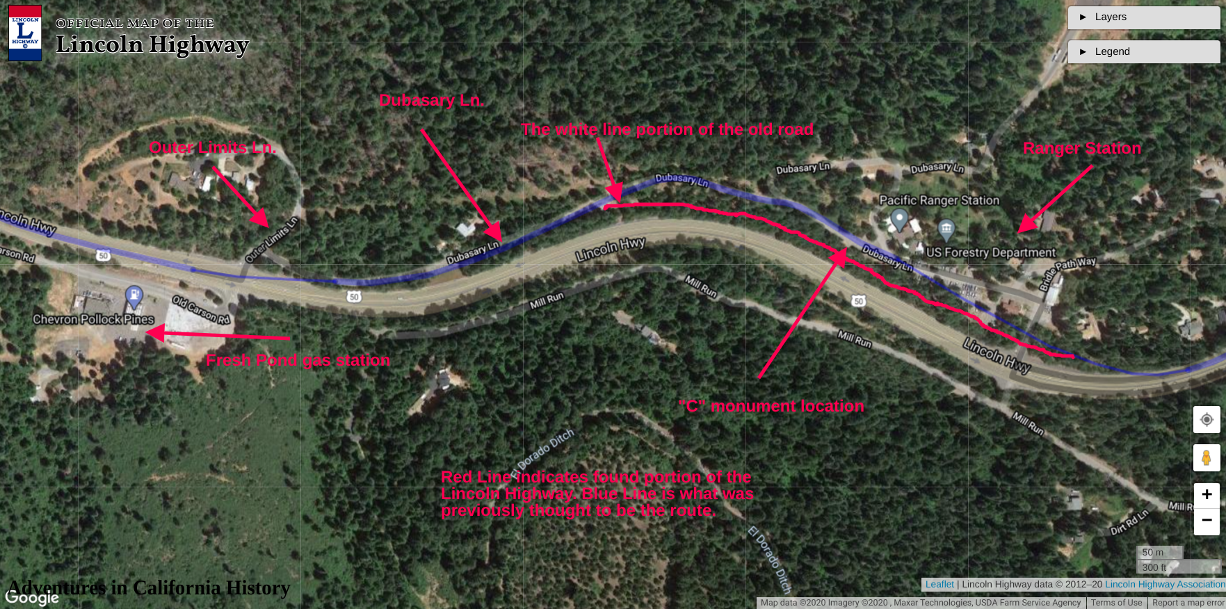
Map showing the found route and some other features. Click map for larger view.
We can surmise that with the modern Highway 50 in the 1950s, the older road was destroyed. It was too close to the new highway, so it was moved away from the freeway and given the name, Dubasary Lane. This newly found route will be presented to the Lincoln Highway Association cartographers for approval and addition to the official map found here.

The Lincoln Highway was America’s first coast-to-coast highway for automobiles. When first planned it followed roads already in place. Here in California's mountains, the old road often followed the older wagon and emigrant trails from the 1800s. Here is no exception as just across Dubasary Lane from the “C” monument is a “T” monument put up by the Trails West organization. It mentions that this is part of the Johnson Cut-Off Trail from the 1850s. Down in the American River Canyon from here was the Bartlett Bridge, which predates the famous Brockliss Bridge. The wooden Bartlett Bridge was destroyed by flood on March 7th, 1855, and replaced with the stone Brockliss Bridge a few miles upriver. We couldn’t find a drawing of the Bartlett Bridge but found this one of the Brockliss Bridge, which the Pony Express used during its incarnation.

Brockliss Bridge over the American River by Edward Vischer. Toll House at right.
Often we find ourselves at some special location in history that even pre-dates the old Lincoln Highway. The old road spans the time from horse and buggy and the new-fangled automobile.
The Lincoln Highway is your road to adventure.