These two photos from Jack Duncan seem to show Highway 40 "near Donner Summit," according to the caption. I'm having a hard time locating this particular spot. It looks much like the area between Cisco Grove and Big Bend, but the old road on the right rises much more rapidly at that location. The second photo below seems to show the same area, but check out all the traffic. If you know where this photo location is, please let us know.
The Lincoln Highway at Donner Summit
The following photographs go with our YouTube video, where Norm Sayler of the Donner Summit Historical Society describes to Trey what we are seeing. You can watch the video at the bottom of this post.
The above photograph shows the first snow removal equipment on Donner Pass. These vehicles didn’t work The Lincoln, but the early Highway 40, which followed the second-generation Lincoln Highway.
Another great photograph is showing the first snow removal equipment on Donner Summit.
The above photo shows an automobile headed down the grade at Donner Summit. This photograph is before the snow removal equipment. The snow was hand dug by eager merchants and others who were looking for the first customer to come over the summit.
A fantastic shot of a couple of automobiles headed down into the auto subway under the Southern Pacific tracks next to the China Wall. The snow looks dirty as the very same people who hand-dug the snow would bring ash and coal dust to sprinkle on the snow in an attempt to help it melt faster.
This view is of the very beginning of the construction of The Rainbow Bridge. We are looking at the right abutment or approach to the bridge. You can see the railroad snow tunnels on the mountain behind. Notice the automobile on the road just before the abutment.
What looks like the Rainbow Bridge is the scaffolding for the new bridge. The actual height of the bridge will reach those two abutments we see towards the top of the photo.
Here is a cool photograph of the construction of the Rainbow Bridge. We can see the new bridge, the roads approaching, and if you look very closely at the very bottom right, you can see an automobile headed up by the small pond and using the original alignment of The Lincoln Highway since the bridge is not yet complete. Then small pond the car is passing was formed by the construction of the second-generation Lincoln, which blocked its outflow.
A beautiful postcard photograph is showing the newly completed second-generation Lincoln Highway bridge, complete with dirt approaches, which changed to asphalt when the road became Highway 40. The plaque pictured used to be at the lookout point near the bridge. It now rests at the Donner Summit Historical Society.
Norm Sayler, History Talks
Recently Monica and I spent a couple of days at The Donner Summit History Museum in Soda Springs. We interviewed Norm Sayler, who's collection makes up most of the items in the museum. Norm is truly a "living legend" in these parts, and we were excited to record his thoughts and remembrances about the history of this most famous of places. Part of the fun of visiting the museum is Norm himself. It's his stories and the way he tells them that pulls you into the conversation.
To convey the feeling one gets when at the museum talking with Norm, we have recorded hours of interviews. This, just over one minute video, is a sample of what we are trying to do. Show the object of interest, in this case, a photo of the recently completed Highway 40 in Auburn, and let Norm discuss what we see. We are putting together a longer video of our visit to The Museum and Norm. I just wanted to try out this method of discussing history, photos, short video, and Norm speaking while we had the time.
The vanishing Lake Van Norden and the Lincoln Highway
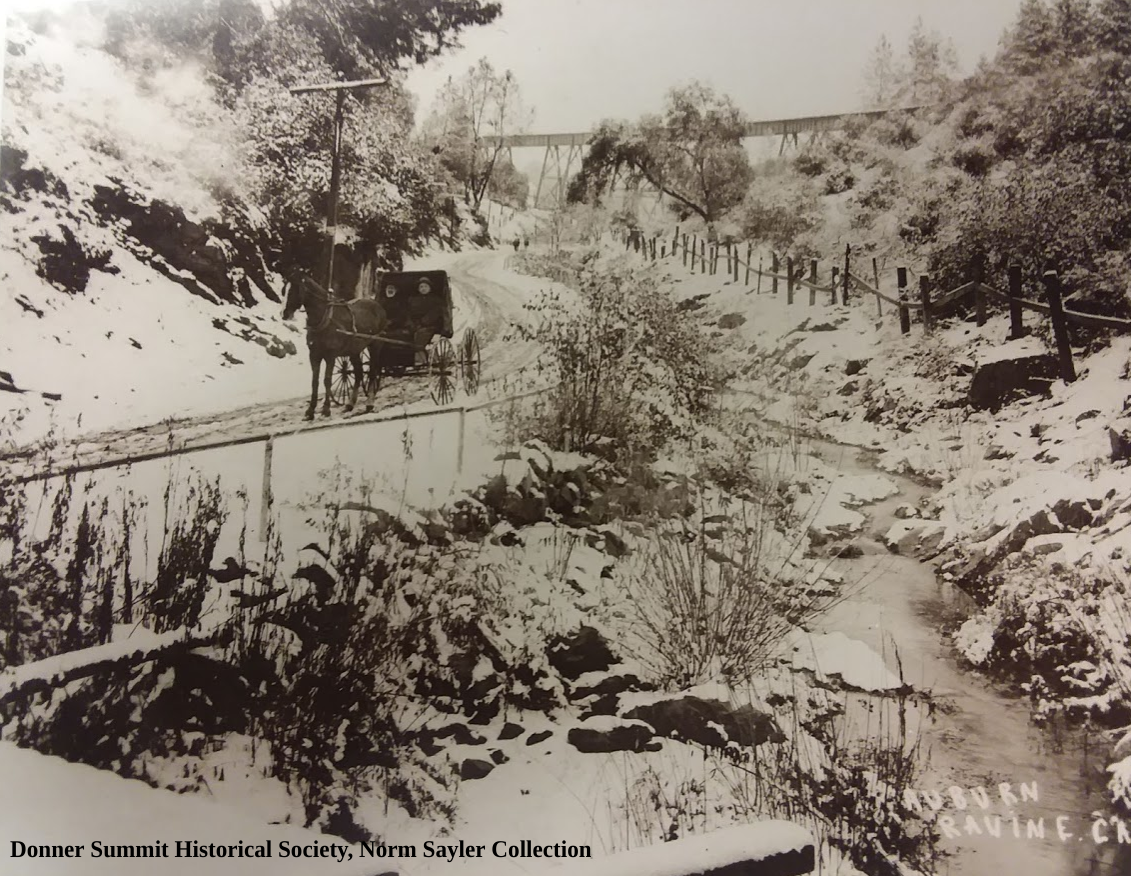
The photo shows an automobile traveling on the Lincoln Highway sometime after 1916 since it shows a large reservoir that almost touches the road. The original alignment of the Lincoln followed Lake Van Norden's northern side from Soda Springs at Highway 80, north of Lake Van Norden, to the now long gone Summit Hotel.
Traveling up the old Highway 40, today's Donner Summit Road, towards Soda Springs one passes Summit Valley off to the right. During the winter it's a snow-covered valley, but in spring with the snowmelt, it turns into Lake Van Norden. It was 1872 when a dam was built across the south fork Yuba River creating the lake. We are not sure why the dam was built, but for awhile the water stored was sent downstream to operate hydraulic mines. In 1886 hydraulic mining was outlawed, so the water was used to irrigate the rapidly growing Central Valley and foothill orchard industry.
In 1916 the Pacific Gas and Electric Company (PG&E) became the owner of the lake and enlarged it to a total of 5600-acre-feet. Every spring the lake would fill with snowmelt, and the slowly lowered during the summer to supply downstream uses. The lowering lake supported a large sheep industry that would use the grass that grew as food.
In 1976 the dam was found to be unsafe, so it was notched to allow less water to be stored. The new lake was only 150-acre-feet in size but still provided recreation and water for wildlife. In 2012 the lake was bought by the Truckee Donner Land Trust from failed developers. According to the Donner Summit Historical Society newsletter, "they inherited a problem because the developers had been told by the State to drain the lake to below fifty acre feet. The Land Trust wanted to sell the valley to the Forest Service which would not take the valley with any lake. The Land Trust did not entertain any other solutions and so opened the drain and completely drained the lake in 2015. If the Forest Service consummates the purchase their plan is to restore the dry meadow to what it was before there was any dam and no summer river." The Truckee Donner Land Trust sees the removal of the dam and lake as a win for the environment, which they detail here.
Be sure to check out the lake within the next couple of weeks, because 2019 is the last year that Lake Van Norden will exist. Destroying Lake Van Norden seems an odd move for a state that seems to always be on the verge of a drought, and is unwilling to build new water storage facilities.
Norm Sayler and the Donner Summit Historical Society
Monica and I have a keen interest in California history, which takes us all over northern California, including our favorites places in the high country of the Sierra. One such place in The Donner Summit Historical Society located in Soda Springs, a mile or so from Donner Summit. This little museum has more exciting stuff from the area than even the state museum by Donner Lake. Unfortunately, the state museum, like the one in Coloma, has turned into what we call a "push button" museum. Clean, neat, and "push the button" for more info. A bit too sterile for us. Contrast that with Donner Summit Historical Society Museum, which is hands-on, and has more artifacts to look at and touch that the state-run museum.
Most important is the man running it, Norm Sayler. Norm has lived most of his life at Donner Summit, where for 46 years he ran Donner Summit Ski Ranch. No one I have met has a more excellent knowledge of the summit areas history and photographs to back it up. Norm's Ski Ranch was the first ski resort to allow snowboarders on its mountain. Snowboards with autographs of the leaders of the sport, thanking Norm, hang in the museum. Norm also was instrumental in saving the historic Rainbow Bridge from destruction when short-sighted supervisors in Nevada County wanted to tear it down! Norm and the Historical Society were also instrumental in having Highway 40 declared a California Historical Highway, giving the old road some protection.
The Museum and historical society have hikes around the summit where the history of this area is discussed and marveled at. The Society has also erected informative signs all around the summit area, which they describe as the "20-mile museum". Pick up a brochure at the museum to follow along. Check out their webpage, and sign up to receive the newsletter, "The Donner Summit Heirloom," which has stories and photos you have likely never seen or heard before.
Donner Summit Historical Society museum is located at Donner Pass Road and Soda Springs Road, in the town of Soda Springs.
Truckee 1919 and The Lincoln Highway "L"
I spent the day at the fabulous Donner Summit Historical Society Museum in Soda Springs. Once again, Norm Sayler, curator of the museum, shared some of his knowledge and rare photographs.
This photo shows Truckee, California in September of 1919. We see a couple of cars on the left next to a gas station, with Red Crown gas advertised. What caught our eye, however, is the large Lincoln Highway "L" that is standing next to the gas station. There appear to be either arrows or wording at the top and bottom of the sign, but we can't make out what it says.
Auburn Ravine
Not sure of the date that this was taken, but likely late 1800’s early 1900’s. The road the wagon is on is, or will become the Lincoln Highway. You can see the railroad trestle in the background. We are facing east. This entire area is now under Interstate 80. The creek you see is contained in a culvert that travels under the freeway for quite a ways. Kids will often climb through the tunnel which the locals call Satan’s Tunnel, to see how far they can get (not recommended). The tunnel starts right where the giant statue of a Gold Miner sits by The Interstate and exits the culvert at The Ophir Road exit.
Location of photo.
Fred's Place, Highway 50, El Dorado County
Rare photo looking west of Fred’s Place, located near mile marker 36, along Highway 50. Fred’s place was a resort and roadhouse built by Anna and Fred Scriggs in 1918 on land leased from Eldorado National Forest. Fred’s Place closed in 1965. That’s a fake CHP patrol car in the middle of the photograph, apparently effective in slowing traffic.
Map of location.
Pacific House in the 1920's
This is Pacific House, guessing sometime in the 1920s. Pacific House is just east of Freshpond on Highway 50. It was a bustling place back in the late 1800s and early 20th Century as the highway passed right in front of the building. In the 1800's it was a stopping spot for people traveling along Johnson's Cut-Off Trail, which climbed up here after crossing the Brockliss Bridge over The American River.
This photo shows just how busy the old Lincoln Highway could get, complete with a cop with high boots walking the cars parked partially on the highway. Today the building exists but is in the midst of slowly collapsing.
Photo from: Donner Summit Historical Society, Norm Sayler Collection.
Lincoln Highway, Emigrant Gap
Monica and I spent a couple of days camping at Prosser Creek Reservoir, just east of Truckee. The reservoir filled a canyon with historic crossings, both The Overland Emigrant Trail, as well as the first generation of The Lincoln Highway. We were able to follow the old trails and enjoy some spectacular scenery.
The highlight to our trip was The Donner Summit Historical Museum, in Soda Springs. This small museum has more Donner Summit History than any other museum I know. It's run by Norm Sayler, who for over 40 years owner and operated The Donner Ski Ranch. He has amassed a collection of Donner Summit memorabilia and photographs that is unparalleled. We spent over 5 hours during two days talking with Norm and going through his amazing collection. There is so much to see and take in that it will require many more trips up to Donner Summit and Soda Springs to help record and preserve what is stored there.
This photograph shows two ladies standing in front of The PG&E (Pacific Gas and Electric) lookout station at Emigrant Gap, around the 1920s. This location is now a large turnout and vista point along Highway 80. If you look closely, you can even see a Lincoln Highway Directional sign on the left of where the women are standing.
The photograph below shows two women on skies near Cisco Grove. Notice the Lincoln Highway Sign buried in the snow and The Transcontinental Railroad Snow Tunnels on the hillside.