• Blog
  • Historic Photos
  • About
  • Search
  • Resources
  • Contact Us
  • Menu

Adventures in California History

  • Blog
  • Historic Photos
  • About
  • Search
  • Resources
  • Contact Us

Sign up!

You can receive our posts sent directly to your e-mail inbox.

We respect your privacy.

Thank you!
20180205_120808.jpg

Pilot Creek Bridge

February 06, 2018 in California

Before Lake Edson was filled, Wentworth Springs Road passed over Pilot Creek, and ran along the south side of the creek. Here we see the concrete bridge, built in 1929, that crossed the creek. I assume it was use until Stumpy Meadows was filled to create Lake Edson. Not sure if there was a bridge here before 1929, or if the road took a different route?

20160731_180556.jpg

A plaque attached to the center of the bridge. Imprinted, but hard to see at the top is the date, 1929.

Tags: Lake Edison, Stumpy Meadows, bridges, Pilot Creek
Comment
20180129_130740.jpg

James Marshall, one man, two graves.

January 30, 2018 in California

When James Marshall died in the town of Kelsey on August 10th, 1885, he wasn't held in as high regard as the "gold discover", until later on. He had moved to Kelsey, after living in Coloma, to hunt for gold, and do blacksmith work. He was all but broke when he died, and was buried in the town of Kelsey, but outside the cemetery. The obelisk pictured above, in Kelsey just off Highway 193,  shows the original site of his grave. 

In May 1890, five years after Marshall's death, Placerville Parlor #9 of the Native Sons of The Golden West successfully advocated the idea of a monument to the State Legislature, which appropriated a total of $9,000 for the construction of a monument and tomb which can be seen today. A statue of Marshall stands on top of the monument, pointing to the spot where he made his discovery in 1848. He now lies buried under the much larger statue in James Marshall Gold Discovery Park in Coloma. 

2014-01-01 14.05.05.jpg
Tags: James Marshall, grave, Kelsey, Coloma
Comment
ES4421HD9ETIKMYPS4IIK2JC6XDHSF (1).jpg

How's the traffic in the canyon today?

January 29, 2018 in California

There have been a number of bridges crossing the confluence of the North and Middle Forks of The American River. This photograph shows a single buggy crossing this "cable bridge", sometime in the early 1900's. You can see some of the buildings just over on the Placer County, north side. These bridges were "toll" bridges, until the State of California took over. Likely you would have paid the bridge keeper on the other side. 

SSKENCVQVDR8EKPAKMBXQKMMME9YIU (1).jpg

You can see the buildings better in this winter view. Horse drawn stages were used for public transportation up until 1915, when they were replaced by automobiles. 

Both photos from: California State Library

Tags: american river, bridges, Cool, Auburn, Highway 193, Highway 49
Comment
20180121_145707.jpg

Willmont Saddle, Colfax, CA.

January 25, 2018 in California

Home sweet home? This small home is located just off Highway 174 on Knorr Swiss Road, east of Colfax. You can see it from the highway on a road I suspect was a part of the old Dutch Flat Wagon Road, then The Lincoln Highway, Highway 40, and now Highway 174. Interstate 80 passed south of this area and now carries all of the interstate traffic. 

There is a brown sign, something like a forest service sign sitting against the rock foundation. It reads, "Willmont Saddle". Willmont saddle is located in The Sawtooth Ridge area, and was used as a trail by members of The Donner Party searching for help. 

The place sure looks like it's been there awhile, but of it's history I can only guess. Where it sit's though, is steeped in history.

Tags: Colfax, Willmont Saddle, Highway 40, Lincoln Highway
Comment
XS3U9T5UV7VRJQL28YDGP19HS82UCY (1).jpg

Aeolia Olive orchard, Auburn, CA.

January 24, 2018 in California

Did you know there is an olive orchard at the top of Highway 49, on the Auburn side of the American River canyon? "Aeolia Heights was once a working orchard producing "Aeolia Olive Oil". 5,000 olive trees were planted in the 1890s by Frederick Birdsall. "The orchard was named for Aeolus, the Greek god of the winds, for the evening breezes that come down the canyon on summer evenings." 

It was quite the operation until the 1950's, when imported olives started to make a dent in the business. Eventually the operation closed in the 1970's. The trees are overgrown now, and mostly unnoticed by those driving Highway 49 from Cool to Auburn. The above photo, taken in 1910, shows a young orchard in it's prime. You can see Highway 193 running along the hill. Auburn is to the left, the town of Cool, about 5 miles to the right.   

Nice Auburn Journal article on the olives here.

Photo: California State Library

Tags: olives, historical, Aeolia, Auburn, Highway 193
Comment
20180121_131111.jpg

Lincoln Highway, Applegate, CA.

January 23, 2018 in California

Just outside of Applegate, Ca., The Lincoln Highway passes through a 1927 subway, under the railroad tracks.  Apparently, the original roadbed actually climbed up, and over the railroad tracks, making for a dangerous mix of trains and autos.. I assume as traffic picked up over the years, the highway department decided to build these subways, thus avoiding car train meetings. 

There use to be an old wagon parked here, likely representing the fact that this is also an old wagon route from the 1800's. Now this old auto has shown up in it's place. A Lincoln Highway tribute, no doubt.

20180121_125107.jpg

This is the view from the old alignment that crossed over the tracks. You can see the subway entrance up ahead, and to the right, below the tracks. 

20180121_125150.jpg

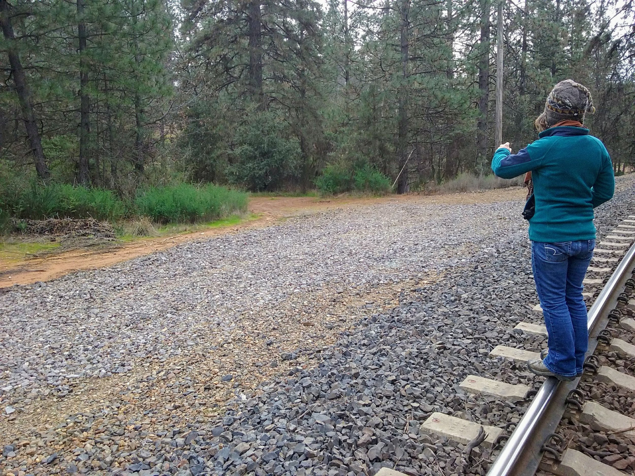
Monica is pointing to where The Lincoln Highways first route came out of the shrubbery, and trees  to cross the tracks. We are facing southwest. 

20180121_125422.jpg

Now we are heading down The Lincoln Highway, after having crossed the railroad tracks, which can be seen up, and to the right. 

Tags: Applegate, Lincoln Highway, railroad, subway
Comment
20180121_120456.jpg

Olivers Gas

January 21, 2018 in California

Olivers Gas is located on both The Lincoln Highway, and Highway 40 in Clipper Gap, CA. This is the last independent operating gas station on the west slope of The Sierra in Placer County. It has been a gas station, bar, and store since the 1920's. The original structure that would have served Lincoln Highway customers burned in the 1940's and was replaced with the present structure that would be familiar to anyone driving on Highway 40 in those day's. 

Before Olivers the site held a gun powder production facility dating from 1889, that lasted until 1917. It closed due to a number of explosions on site, including one that claimed 22 lives. Some of the ruins are still visible. The Lincoln Highway leaves this roadbed and turns right just up at the bend. 

20180121_120855.jpg

This is the view coming down The Lincoln, headed west.  

20180121_120848.jpg

This is facing the opposite way on The Lincoln Highway, east and uphill. Very nice old home on left must have witnessed a lot of interesting events over the years. We are at an elevation in The sierra of about 3000'. 

Tags: Auburn, Lincoln Highway, Highway 40, Olivers Gas
1 Comment
27023391_1901844343163351_6306745991372712372_o.jpg

The Hill Hotel, El Dorado, CA

January 20, 2018

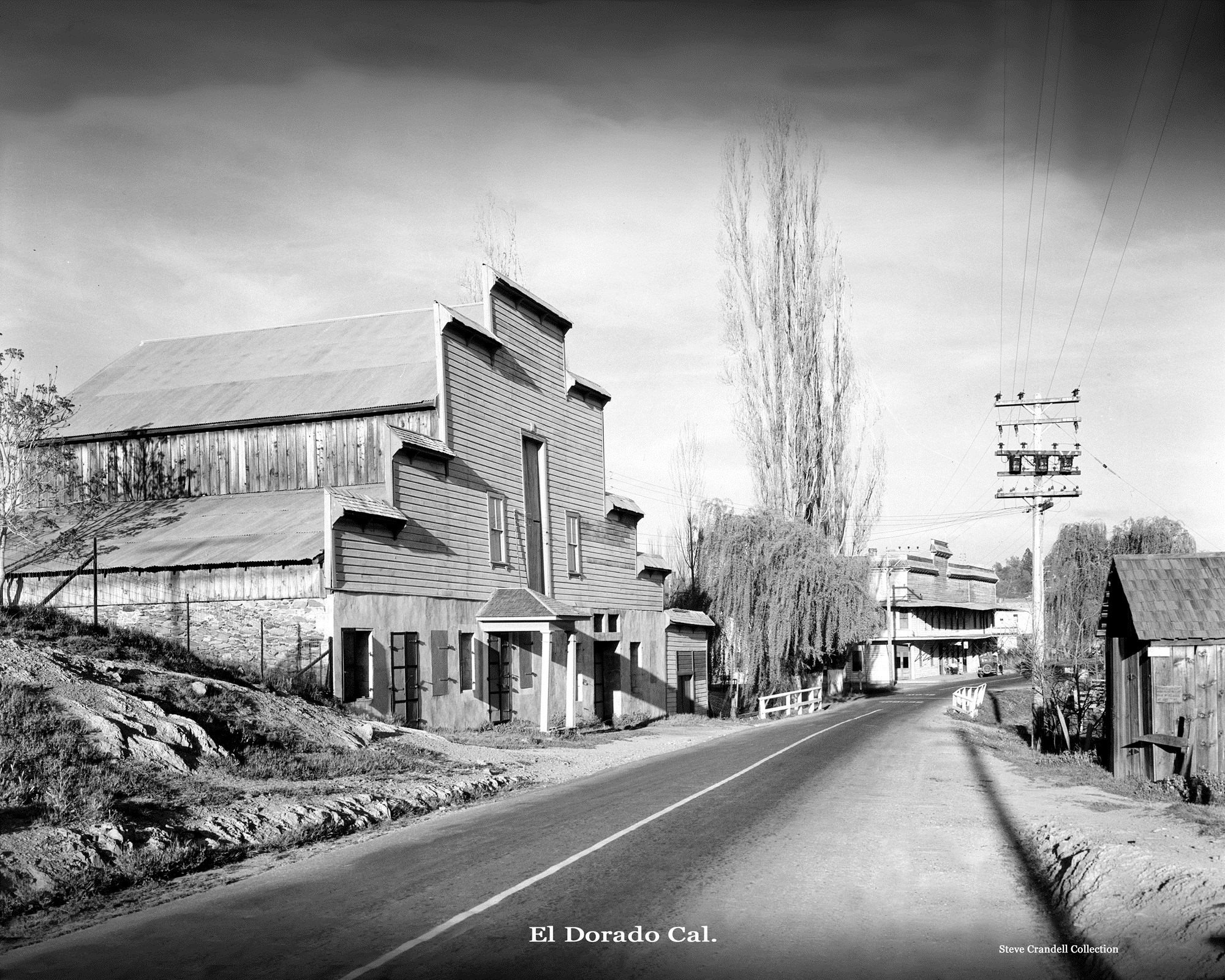
The Lincoln Highway in the old town of El Dorado, CA. Picture date is unknown, but there is a old time car, Lincoln Highway era, parked down the road in the first photo. In this photo we are facing east. Interestingly, this photo came to my attention because of another photo of the building the car is parked in front of. The second photo is of the same building, facing west. It was unidentified, location unknown. After posting on a Placerville Facebook group, someone was able to ID the building as The Hill Hotel, in El Dorado on The old Highway 50, and earlier Lincoln Highway. Hotel burned down sometime after 1920's, and before 1960.

Photo from: California State Library http://bit.ly/2EXA157

Photo from: California State Library http://bit.ly/2EXA157

screenshot-www.google.com-2018-01-20-12-17-54-703.png

The same view today. Plesant Valley Road, El Dorado, CA., facing east.

Comment
UT1XVXD46C8RVJC95JCDSDNYKH6LTM (1).jpg

Filipini store, Garden Valley, California 1908

January 18, 2018 in California

Driving through Garden Valley on Marshall Road, headed east, you'll pass a old rock ruin of a building next to the real estate office.  This is all that remains of "Bill Tell's" store, built in 1855. It was owned by a Mr. William Pedrini, who owned a large parcel of land west of Garden Valley, known then as "Tell's" Ranch. During winter the cattle would stay in Garden Valley, but during summer they would drive their cattle up-country into the high Sierra, near "Tell's Peak". His nephew, Rinaldo Filipini arrived from Switzerland in 1859, and became the stores clerk. During the 1870's this family had one of the largest dairies in El Dorado County. In 1875 Rinaldo became a partner in the business, and through the years the place became known as, "The Filipini Store".  

Garden Valley had two big dairy ranches during the 1880's, The Filipini and Bacchi ranches. The Filipini Ranch, in 1881 produced four ton's of cheese, and 3 ton's of butter! It's called Garden Valley for a reason. In 1909 the store was sold to A.F. Forni, so the man in the picture above could be Mr. Filipini . 

During the relative quiet of the 1930's in The Foothills, it housed the Garden Valley post office, and still had a pine bar from the early days. During the 1930's the wooden parts of the building were destroyed, and today all that remains today is the stone foundation, wall's, and two steel doors you can see when driving by. 
screenshot-www.google.com-2018-01-17-22-20-14-908.png

The old stone building today on Marshall Road. 

Tags: Garden Valley, Filipini, store
Comment
F56U2DIAPPEJ121BJAYPFKDMHNLDLK.jpg

Horsetail Falls on Highway 5O

January 17, 2018

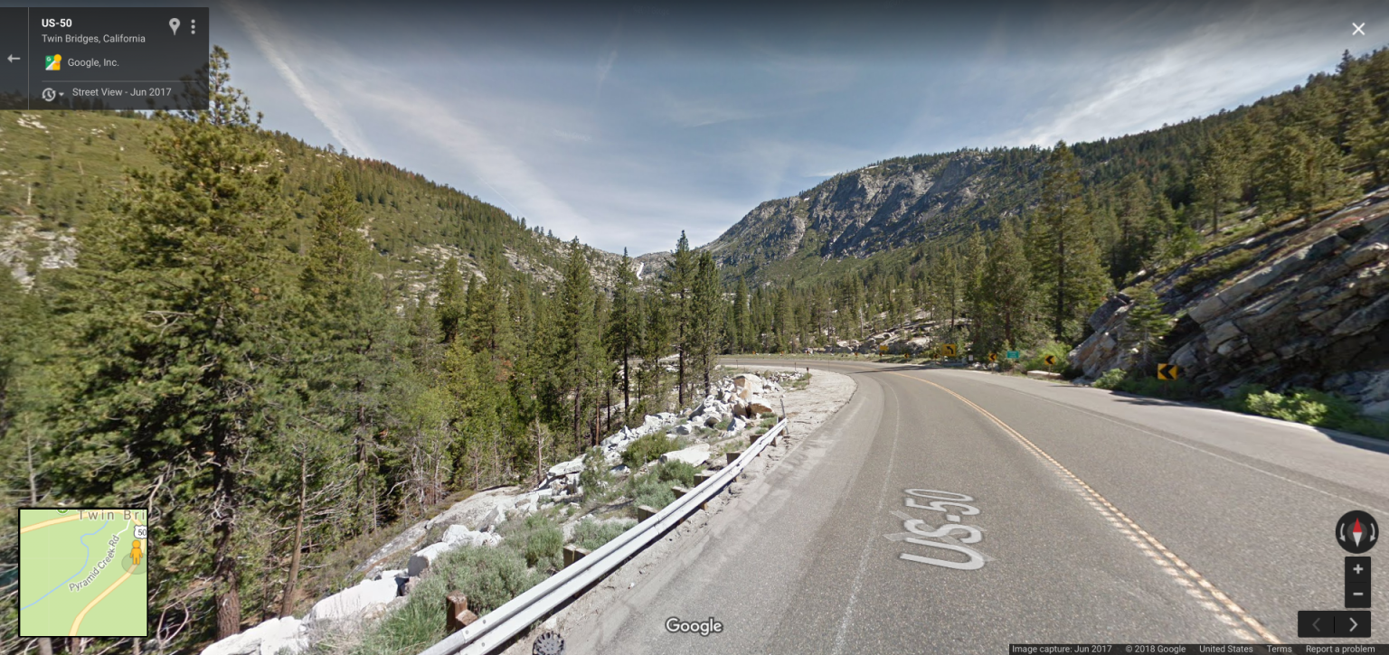
It's 1930 and we have begun our decent, having just passed over Echo Summit. This is a much improved "modern" decent from the old road alignment at Slippery Ford, which carried pioneers, The Pony Express, and The Lincoln Highway. Off in the distance is Horsetail Falls, fed from The Desolation Wilderness, and Woods Lake. Elevation about 7000'. Traffic seems light, must be a weekday. Next stop, Twin Bridges, just around the bend.

Photo from: California State Library

screenshot-www.google.com-2018-01-17-21-49-23-560.png

The same view today.

Tags: Horsetail Falls, Echo Summit, Sier, 1930's, Highway 50
Comment
20180115_124343.jpg

Pacific House on the old emigrant trail

January 16, 2018 in California

Drove around Pacific House, El Dorado County, CA, which was an emigrant wagon road, Pony Express, Lincoln Highway, and Highway 50 landmark. Apparently, many well-known folks stayed here, including Mark Twain. Not much going on these days. We are facing east, and just a little further ahead, the Lincoln Highway leaves Peavine Ridge Road and connect into the present day Hwy. 50. Hwy. 50 is just out of the picture on the right. Peavine Ridge road continues down into the American River Canyon.

PacificHouse.jpg
Tags: Pacific House, El Dorado County, Peavine Ridge Road, Pony Express, Lincoln Highway, Emigrant Trail, Highway 50
Comment
Detention camp between Shingle Springs and White Rock, prisoners finishing the last gap between Placerville and Sacramento, California

Detention camp between Shingle Springs and White Rock, prisoners finishing the last gap between Placerville and Sacramento, California

Folsom prisoners and The Lincoln Highway

January 10, 2018 in California

Here we see the construction of The Lincoln Highway, near Clarksville. The pavement was poured 10" thick, and convicts from Folsom Prison were used in it's construction. Follow this link for a picture you can zoom in on. 

Tags: Clarksville, Shingle Springs, Lincoln Highway, Folsom, Prison, concrete
Comment
linchigh_lhc0041_full_1949_1158__0_native (4).jpg

Paving The Lincoln Highway, Shingle Springs, CA.

January 09, 2018 in California

Here we see a highway crew pouring concrete for The Lincoln Highway in Shingle Springs. This spot looks real familiar. I think it's Durock Road right about where the pipe manufacturing plant would be, in that field.

Source: http://quod.lib.umich.edu/l/linchigh/x-lhc0041/lhc0041 Tags: Shingle Springs, Lincoln Highway, concrete
Comment
20170307_130516.jpg

Propellers on parade

January 06, 2018 in California

At first we thought this place reconditioned old propellers for use as engines on airplanes. Turns out, they are reconditioned to be used as frost protection in vineyards. The photo was taken in St. Helena, CA, wine country. They're mounted on tall supports, over the vineyards. When frost arrives, they're turned on, moving the air and preventing damage to the emerging grapes shoots in spring. 

Tags: St. Helena, California, propellers, wine, garpes
Comment
P5240105.JPG

The Golden Gate

January 06, 2018 in California

The view from The Lincoln Park golf course. Years ago it was a cemetery for the less "well off" of the city. When they dug up, and moved all the burials in SF to Colma back in the 19th century, they evidently forgot this one. Nice view.

Tags: San Francisco, Lincoln Park, cemetary, Golden Gate Bridge
Comment
Prev / Next

Use the box below to find specific subjects.

Archive

  • July 2023
    • Jul 23, 2023 Emigrant Trail at Caples Lake, Alpine County Jul 23, 2023
  • August 2022
    • Aug 12, 2022 1922 Moreland Truck at Johnson's Pass Aug 12, 2022
  • November 2021
    • Nov 2, 2021 Lincoln Highway artifact found! Nov 2, 2021
  • June 2021
    • Jun 23, 2021 Following the Lincoln Highway at Zephyr Cove, Nevada Jun 23, 2021
  • March 2021
    • Mar 26, 2021 Folsom, a Lincoln Highway Community Mar 26, 2021
  • February 2021
    • Feb 17, 2021 Bowman crossing and a newly found alignment of the Lincoln Highway. Feb 17, 2021
  • January 2021
    • Jan 31, 2021 Iowa Hills William "Seattle Bill" James, baseball legend Jan 31, 2021
    • Jan 30, 2021 Horse team carrying sand for the construction of the Mountain Quarries Railroad Jan 30, 2021
    • Jan 28, 2021 Rattlesnake Bar Road and Bridge site Jan 28, 2021
    • Jan 16, 2021 The Quonset Hut Motel near Colfax Jan 16, 2021
    • Jan 14, 2021 Brockliss Bridge site Jan 14, 2021
    • Jan 11, 2021 Alta and the Lincoln Highway Jan 11, 2021
    • Jan 10, 2021 A busy day at Baxter along old Highway 40 Jan 10, 2021
    • Jan 9, 2021 A summertime day in Auburn, 1916. Jan 9, 2021
    • Jan 8, 2021 Georgetown Junction, historic crossroads along the Lincoln Highway Jan 8, 2021
    • Jan 2, 2021 Truckee on the Lincoln Highway Jan 2, 2021
  • December 2020
    • Dec 4, 2020 Strawberry on the Lincoln Highway's southern route, part 6. Dec 4, 2020
    • Dec 3, 2020 A crossroads on the northern route of the Lincoln Highway, Part 5 Dec 3, 2020
  • November 2020
    • Nov 28, 2020 Colfax, Placer County, 1870s Nov 28, 2020
    • Nov 26, 2020 Slippery Ford to Strawberry on the Lincoln Highway, part 5 Nov 26, 2020
    • Nov 22, 2020 Dog Valley to Truckee on the northern route of the Lincoln Highway, Part 4 Nov 22, 2020
    • Nov 20, 2020 The children of Long Valley School, Placer County, 1890 Nov 20, 2020
    • Nov 19, 2020 The Falls of Salmon Falls. Nov 19, 2020
    • Nov 18, 2020 Slippery Ford on the Lincoln Highways southern route, Part 4 Nov 18, 2020
    • Nov 14, 2020 Verdi to Henness Pass Road on the old Lincoln Highway northern route, part 3 Nov 14, 2020
    • Nov 11, 2020 Echo Summit to Slippery Ford on the Lincoln Highway southern route, Part 3 Nov 11, 2020
    • Nov 8, 2020 Greenwood, El Dorado County school and playground, 1953 Nov 8, 2020
    • Nov 7, 2020 Verdi, Nevada to the California line on the northern route of the Lincoln Highway, Part 2 Nov 7, 2020
    • Nov 5, 2020 The Lodge at Echo Summit, Lincoln Highway, Part 6 Nov 5, 2020
  • October 2020
    • Oct 31, 2020 1895 Citrus Colony Cricket Team, Rocklin, California Oct 31, 2020
    • Oct 30, 2020 The Lincoln Highway, EL Dorado County, Johnson's Pass, Part 5 Oct 30, 2020
    • Oct 29, 2020 The Lincoln Highway, Verdi, Nevada Oct 29, 2020
    • Oct 24, 2020 Meyers Grade to Johnson's Pass, Lincoln Highway in El Dorado County, Part 4 Oct 24, 2020
    • Oct 23, 2020 Aerial view Auburn at the turn of the century Oct 23, 2020
    • Oct 22, 2020 The Lincoln Highway at Meyer's, El Dorado County Part 3 Oct 22, 2020
    • Oct 21, 2020 The Lincoln Highway in El Dorado County, Part 2, historic Trout Creek Bridge Oct 21, 2020
    • Oct 18, 2020 Exploring the Lincoln Highway in El Dorado County, Part 1 Oct 18, 2020
    • Oct 16, 2020 The Yuba River at Big Bend Oct 16, 2020
    • Oct 14, 2020 Big Bend, crossroads in history. Oct 14, 2020
    • Oct 10, 2020 Robert Fowler and his airplane Oct 10, 2020
    • Oct 8, 2020 A 1923 alignment of the Lincoln Highway found Oct 8, 2020
    • Oct 1, 2020 Lincoln Highway alignment found near Fresh Pond Oct 1, 2020
  • September 2020
    • Sep 30, 2020 The Lincoln Highway from Fry Creek to Milestone 29 Sep 30, 2020
    • Sep 22, 2020 The Summit Station and Hotel, Donner Summit Sep 22, 2020
    • Sep 19, 2020 Once upon a time at "Lookout Point", Emigrant Gap. Sep 19, 2020
    • Sep 12, 2020 The Yuba River, a historic transportation corridor Sep 12, 2020
    • Sep 11, 2020 Dutch Flat Wagon Road at Castle Creek, Soda Springs. Sep 11, 2020
    • Sep 6, 2020 Big Bend in Transportation History Sep 6, 2020
    • Sep 5, 2020 Yesterday and today on the Lincoln Highway, Big Bend. Sep 5, 2020
    • Sep 4, 2020 Lincoln Highway bridge at Rainbow in the Sierra Nevada Sep 4, 2020
    • Sep 3, 2020 Highway 40 crossing at Emigrant Gap Sep 3, 2020
  • August 2020
    • Aug 6, 2020 Lost Lincoln Highway alignments Aug 6, 2020
    • Aug 1, 2020 TC Wohlbrück and his Canteen Service Stations Aug 1, 2020
  • March 2020
    • Mar 27, 2020 Georgetown Divide History Tour, Part 4 Mar 27, 2020
    • Mar 21, 2020 Green Valley Road Historical Tour, Part 3 Mar 21, 2020
    • Mar 19, 2020 Leland Stanford and his store Mar 19, 2020
    • Mar 18, 2020 Georgetown Divide History Tour, Part 3 Mar 18, 2020
    • Mar 14, 2020 Green Valley Road History Tour, Part 2 Mar 14, 2020
    • Mar 12, 2020 Georgetown Divide History Tour, Part 2 Mar 12, 2020
    • Mar 7, 2020 The Green Valley Road History Tour! Mar 7, 2020
    • Mar 6, 2020 Finding Historic "C" Markers Mar 6, 2020
    • Mar 5, 2020 The old Lotus Bridge site, and the Georgetown Divide history tour Mar 5, 2020
    • Mar 4, 2020 A quiet road in Roseville Mar 4, 2020
  • February 2020
    • Feb 28, 2020 Wimpy's Fireplace Feb 28, 2020
    • Feb 8, 2020 Sam Kyburz house, Clarksville Feb 8, 2020
    • Feb 7, 2020 Tobacco growing in Placer County Feb 7, 2020
    • Feb 5, 2020 The Rolling Hills Hotel Feb 5, 2020
  • January 2020
    • Jan 30, 2020 New York Ravine, Salmon Falls Jan 30, 2020
    • Jan 23, 2020 Georgetown fire of 1869 Jan 23, 2020
    • Jan 22, 2020 The W A Thomas Store, Roseville Jan 22, 2020
    • Jan 19, 2020 The old swimming hole at Rattlesnake Bar Jan 19, 2020
    • Jan 18, 2020 The Hogsback Mine near Foresthill Jan 18, 2020
    • Jan 17, 2020 Kentucky House, on the old Coloma-Folsom Road Jan 17, 2020
    • Jan 16, 2020 Otwell Grocery Store along the Lincoln Highway. Jan 16, 2020
    • Jan 10, 2020 Auburn Ski Club Brochure, 1934 Jan 10, 2020
    • Jan 9, 2020 Pelton Water Wheel, Mammoth Bar Mine, 1895 Jan 9, 2020
    • Jan 8, 2020 Central Square, Auburn, California Jan 8, 2020
    • Jan 4, 2020 Highway 40 bridge construction, Colfax, 1938 Jan 4, 2020
    • Jan 2, 2020 "Shafthouse of the Sherman Mine perched high up on the hillside overlooking the town". Jan 2, 2020
    • Jan 1, 2020 The Third Strawberry House Jan 1, 2020
  • December 2019
    • Dec 28, 2019 Looking north on Lincoln Way Dec 28, 2019
    • Dec 20, 2019 Auburn Ski Club at Cisco Grove. Dec 20, 2019
    • Dec 19, 2019 Quiet day on Highway 40, Auburn Dec 19, 2019
    • Dec 18, 2019 Damascus, a ghost town in Placer County Dec 18, 2019
    • Dec 17, 2019 Iowa Hill baseball team and a surprise. Dec 17, 2019
    • Dec 13, 2019 Iowa Hill Baseball Team Dec 13, 2019
    • Dec 12, 2019 Placer Garage, Lincoln Highway, Auburn Dec 12, 2019
    • Dec 10, 2019 Deadwood, Placer County Dec 10, 2019
    • Dec 9, 2019 Auburn old town, no more Dec 9, 2019
    • Dec 8, 2019 Highway 40 Construction Dec 8, 2019
  • November 2019
    • Nov 29, 2019 Strawberry House, there were two locations. Nov 29, 2019
    • Nov 23, 2019 Johnson's Pass on the Lincoln Highway Nov 23, 2019
    • Nov 21, 2019 Auburn railroad crossing gets a new addition Nov 21, 2019
  • October 2019
    • Oct 31, 2019 Lincoln Highway 106 years old today! Oct 31, 2019
    • Oct 19, 2019 The Pioneer! Oct 19, 2019
    • Oct 14, 2019 Then and now, along the old Lincoln Highway in Penryn Oct 14, 2019
  • September 2019
    • Sep 30, 2019 Sierra Summit-Truckee Highway Sep 30, 2019
    • Sep 29, 2019 Summit of the Sierra Sep 29, 2019
    • Sep 26, 2019 Trout Creek bridge date Sep 26, 2019
    • Sep 25, 2019 Found! 1923 alignment of the Lincoln Highway. Sep 25, 2019
    • Sep 19, 2019 Highway 50 at Twin Bridges Sep 19, 2019
    • Sep 15, 2019 Whitehall on the Lincoln Highway Sep 15, 2019
    • Sep 14, 2019 Placerville to sign it's section of the Lincoln Highway! Sep 14, 2019
    • Sep 4, 2019 1919 Army Convoy film, Part II Sep 4, 2019
    • Sep 1, 2019 The Convoy is Coming! Sep 1, 2019
  • August 2019
    • Aug 25, 2019 Truck entering new snowshed subway at Donner Summit Aug 25, 2019
    • Aug 23, 2019 Lincoln Highway by Donner Lake Aug 23, 2019
    • Aug 22, 2019 Donner Lake Camp Aug 22, 2019
    • Aug 21, 2019 Lets stay in a Quonset hut tonight! Aug 21, 2019
    • Aug 19, 2019 Dedication of corner stone for Donner Memorial Aug 19, 2019
    • Aug 17, 2019 Donner Monument, unfinished Aug 17, 2019
    • Aug 15, 2019 Army Convoy, 1919 Aug 15, 2019
    • Aug 13, 2019 Dedication of The Pioneer Monument Aug 13, 2019
    • Aug 9, 2019 Historic highway pole markers Aug 9, 2019
    • Aug 8, 2019 Victory Highway at Boca Aug 8, 2019
    • Aug 7, 2019 Gold Run on Highway 40 Aug 7, 2019
    • Aug 7, 2019 Where was this highway photo taken? Aug 7, 2019
    • Aug 4, 2019 The Lincoln Highway at Donner Summit Aug 4, 2019
    • Aug 2, 2019 Norm Sayler, History Talks Aug 2, 2019
    • Aug 1, 2019 The vanishing Lake Van Norden and the Lincoln Highway Aug 1, 2019
  • July 2019
    • Jul 31, 2019 Norm Sayler and the Donner Summit Historical Society Jul 31, 2019
    • Jul 31, 2019 Truckee 1919 and The Lincoln Highway "L" Jul 31, 2019
    • Jul 29, 2019 Auburn Ravine Jul 29, 2019
    • Jul 27, 2019 Fred's Place, Highway 50, El Dorado County Jul 27, 2019
    • Jul 26, 2019 Pacific House in the 1920's Jul 26, 2019
    • Jul 24, 2019 Lincoln Highway, Emigrant Gap Jul 24, 2019
    • Jul 21, 2019 Weimar subway Lincoln Highway logo Jul 21, 2019
    • Jul 11, 2019 Walk with history Jul 11, 2019
    • Jul 10, 2019 Weimar Crossroads railroad subway painted Jul 10, 2019
    • Jul 7, 2019 Eisenhower and Army convoy leave Washington DC headed to San Francisco Jul 7, 2019
    • Jul 1, 2019 Painting Lincoln Highway Logo, Newcastle 1910 bridge. Jul 1, 2019
  • June 2019
    • Jun 29, 2019 Interstate Highway system signed in law on this date, 1956 Jun 29, 2019
    • Jun 20, 2019 Bachelor Buttons for emergency repairs Jun 20, 2019
    • Jun 15, 2019 Who invented the "rearview mirror"? Jun 15, 2019
    • Jun 14, 2019 Lincoln Highway Travelers Guide Jun 14, 2019
    • Jun 13, 2019 Gold Discovery Centennial Celebration in Coloma, California Jun 13, 2019
    • Jun 7, 2019 Odd Fellows Lodge, Georgetown Jun 7, 2019
    • Jun 2, 2019 Adventures in California History, Lincoln Highway style Jun 2, 2019
  • February 2019
    • Feb 21, 2019 Ranger Survey Ship, and sailors 1890 Feb 21, 2019
    • Feb 20, 2019 Fingal, Riverside County, Sunset Limited train 1898 Feb 20, 2019
    • Feb 10, 2019 Day at the beach in San Francisco, 1903 Feb 10, 2019
  • December 2018
    • Dec 13, 2018 Spenceville, a copper mining town Dec 13, 2018
    • Dec 12, 2018 Finding stuff on the way to Timbuctoo Dec 12, 2018
    • Dec 7, 2018 We're on our way to Timbuctoo! Dec 7, 2018
    • Dec 1, 2018 Headed back to Wheatland Dec 1, 2018
  • November 2018
    • Nov 30, 2018 Rattlesnake Bar Bridge site Nov 30, 2018
    • Nov 27, 2018 At the end of the trail Nov 27, 2018
    • Nov 26, 2018 A Lincoln Highway artifact discovered! Nov 26, 2018
    • Nov 23, 2018 A lost section of Highway 40 at Eagle Lakes Road. Nov 23, 2018
    • Nov 17, 2018 Searching for the Emigrant Trail at Alder Creek Nov 17, 2018
    • Nov 14, 2018 Searching for the Emigrant Trail, Mt. Olive Road, Nevada County Nov 14, 2018
    • Nov 9, 2018 Donner Camp Historic Park Nov 9, 2018
    • Nov 1, 2018 Taking the trip from Auburn to Truckee Nov 1, 2018
  • October 2018
    • Oct 24, 2018 Verdi, travelling through history Oct 24, 2018
    • Oct 21, 2018 Our first "adventure" map! Oct 21, 2018
    • Oct 13, 2018 Trademarks of early California Oct 13, 2018