

This beautiful scene is looking east from the Rainbow Lodge, where we can see the present bridge crossing at left, built-in 1928. This is the south fork of the Yuba River, which provides a natural passage through the Sierra Nevada mountains. The river begins near Donner Summit and flows through Summit Valley, Soda Springs, and eventually here where it makes a “big bend”.
Big Bend is a natural crossing spot for travelers starting with the native people who inhabited this land. The first pioneers to come this way where the Steven-Townsend-Murphy party and their covered wagons. Some of the party over-wintered here, and one of their party, Moses Schallenberger, was caught in a snowstorm and spent the winter of 1844 in a tiny cabin on the east shore of Donner Lake. He was eventually rescued, and the cabin he stayed in was put to use a couple of years later in 1846 by members of the Donner Party.
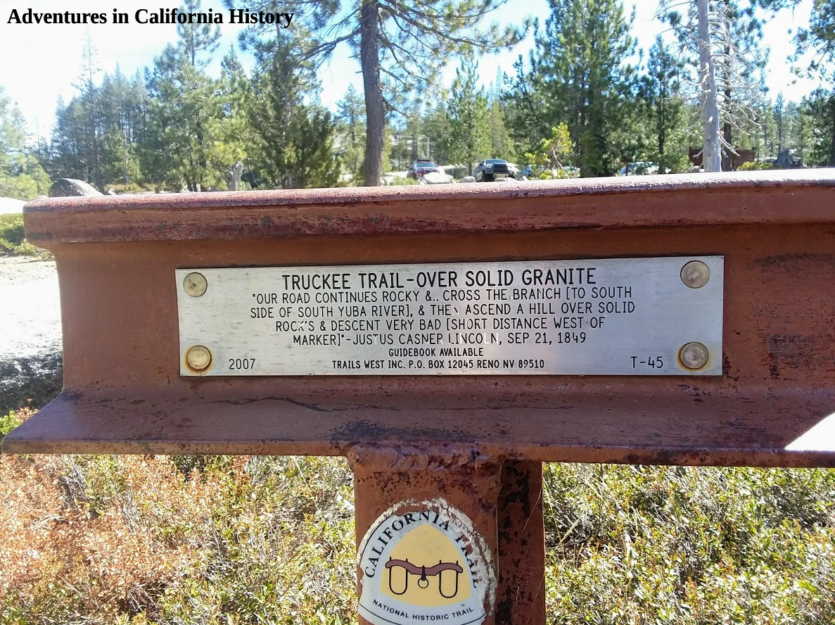
There are emigrant trail traces still to be found in Big Bend. Trails West Association has two of its “T” markers in Big Bend. These markers are placed on or near the original emigrant trails, and each has a quotation from an emigrant diary describing the place where the markers are today. The one pictured above is located just 50 yards north of the Lock Leven Trailhead parking (see map).
The emigrants lowered their wagons down the rocks and followed the S. Yuba River, staying on the south side, where the trail, after crossing today’s Hampshire Rocks Road, follows the Dutch Flat Wagon Roads path. Today the trial is named “Old Wagon Road” and follows the river for about a 1/2 mile.
This section of the trail on Old Wagon Road is magical as you are walking on all the trails at once. Following in the pioneers' footsteps, we cross a Lincoln Highway era concrete bridge and another creek with an old metal culvert exposed.

Metal Lincoln Highway era culvert.
Soon we reach the Trails West “T” Marker #46, which lets us know that this is where the emigrant trail leaves the route of the Dutch Flat Wagon Road and heads up the hill. They couldn’t proceed any further as the rock cliff juts into the water, making passage impossible for the earliest travelers.

In the photo below, we see the emigrant trail heading up the hill, past our bikes, while the Dutch Flat Wagon Road continues, following the river. The builders of that road used rock retaining walls so the trail could continue along the river. These retaining walls over 100 years old still support the old roadbed.

The emigrant trail goes left and up, past our bikes. The Lincoln Highway continues starlight.
We followed the emigrant trail markers for a bit, as we had heard there was a pioneer grave somewhere along the trail near here. The photo below shows the emigrant trail's view back down to our bikes leaning against the “T” marker. Once again, we are amazed at these early travelers' perseverance making climbs such as this with all their possessions in a wagon pulled by oxen.

Looking down from the emigrant trail. You can see our bikes leaning against the “T” marker.
We couldn’t find the pioneer grave and decided to head back down to the river and the road. If you follow the Dutch Fat Wagon Road/Lincoln Highway further west, you rise above the river and can admire the fantastic rock work used for this section. Check out the two photos below taken 100 years apart.

Theodore Wohlbrück photograph cutesy of the Donner Summit Historical Society, Norm Sayler collection.

Looking east on the old Lincoln Highway above the S. Yuba River, Big Bend.
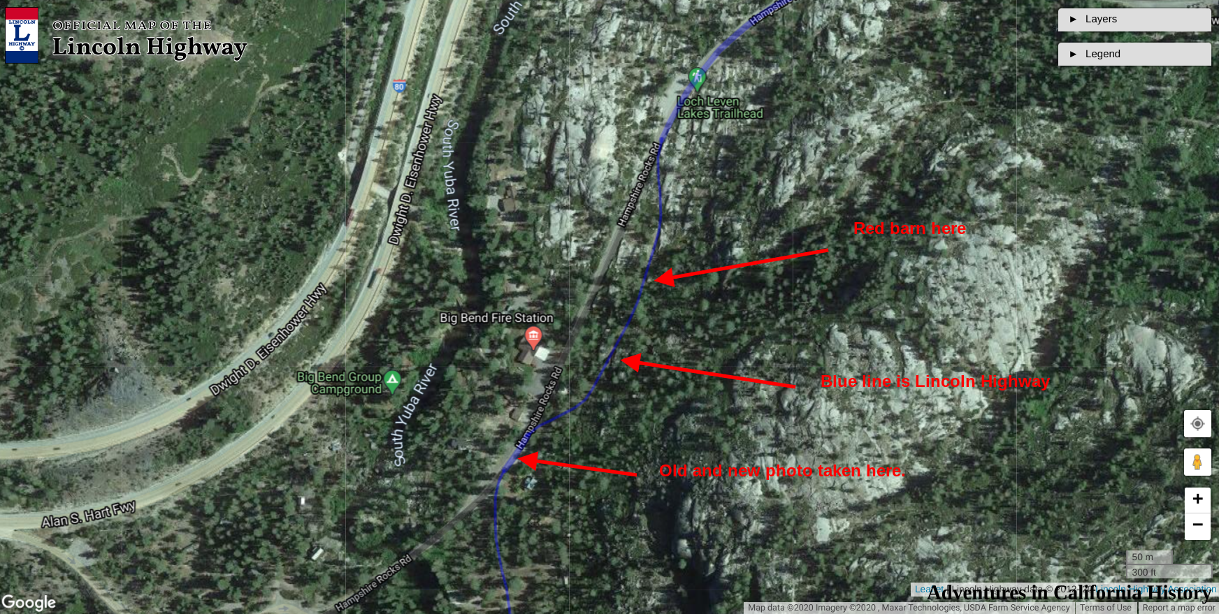
The above photo is taken near the end of the old road, which was destroyed during Interstate 80. Below is a map showing some more of the features mentioned in the post. Fall is an ideal time to visit as the trees start to change color, and the temperatures make for great biking or hiking weather.
Through this narrow passage in the Sierra Nevada mountains, thousands of pioneers and later motorists passed on their way to the Golden State. Big Bend is etched into California History.

Map showing the location of certain features along the emigrant trail in Big Bend.